


<< Text Pages >> Willing Walls Warren Ring Cairn - Ring Cairn in England in Devon
Submitted by Anne T on Monday, 07 October 2002 Page Views: 8697
Neolithic and Bronze AgeSite Name: Willing Walls Warren Ring Cairn Alternative Name: Turner A1; Willing Walls 5; Willing Walls Warren Stone CircleCountry: England County: Devon Type: Ring Cairn
Nearest Town: Princetown Nearest Village: Lee Moor
Map Ref: SX58186517 Landranger Map Number: 202
Latitude: 50.469156N Longitude: 3.999761W
Condition:
| 5 | Perfect |
| 4 | Almost Perfect |
| 3 | Reasonable but with some damage |
| 2 | Ruined but still recognisable as an ancient site |
| 1 | Pretty much destroyed, possibly visible as crop marks |
| 0 | No data. |
| -1 | Completely destroyed |
| 5 | Superb |
| 4 | Good |
| 3 | Ordinary |
| 2 | Not Good |
| 1 | Awful |
| 0 | No data. |
| 5 | Can be driven to, probably with disabled access |
| 4 | Short walk on a footpath |
| 3 | Requiring a bit more of a walk |
| 2 | A long walk |
| 1 | In the middle of nowhere, a nightmare to find |
| 0 | No data. |
| 5 | co-ordinates taken by GPS or official recorded co-ordinates |
| 4 | co-ordinates scaled from a detailed map |
| 3 | co-ordinates scaled from a bad map |
| 2 | co-ordinates of the nearest village |
| 1 | co-ordinates of the nearest town |
| 0 | no data |
Internal Links:
External Links:
Stone Circle/Stone Ring Cairn in Devon
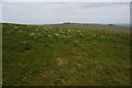
Information about the Willing Walls Warren Stone Ring Cairn Circle comes from the Prehistoric Dartmoor Walks (PDW) website. Their notes tell us: "Willings Walls Warren, Lee Moor. Unusual stone circle. Two kists nearby. Plan. A reave interferes with the circumference of the circle. Four groups of stones are in the circle. No trace of barrow within the circle; and no evidence to show that the stones were ever cists ..... A 40m diameter circle consisting of 5 groups of stones. It touches and is incorporated into the Willings Walls Reave."
The PDW web page gives links to further information on Pastscape, Monument Number 438720, which gives slightly different information: "in the area at which Willing Walls Reave turns through 40 degrees (SX 5818 6516) there are several upright slabs which be heavily robbed cists. Situated on a stone shelf at 330 metres OD are the remains of a near circular structure."
This cairn is also recorded as MDV3438 (RING CAIRN in the Parish of Shaugh Prior), and scheduled as part of Historic England List Entry No. 1019083 (Medieval farmstead and field system, length of Willings Walls Reave, four round cairns, a ring cairn and pillow mounds at Willings Walls Warren).
Note: Have you visited this site? Do you have any photographs, images or further information you can add?
You may be viewing yesterday's version of this page. To see the most up to date information please register for a free account.
Do not use the above information on other web sites or publications without permission of the contributor.
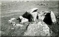
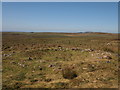
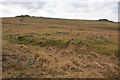
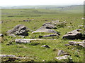
Nearby Images from Geograph Britain and Ireland:
©2022(licence)
©2012(licence)
©2009(licence)
©2014(licence)
©2014(licence)
The above images may not be of the site on this page, they are loaded from Geograph.
Please Submit an Image of this site or go out and take one for us!
Click here to see more info for this site
Nearby sites
Key: Red: member's photo, Blue: 3rd party photo, Yellow: other image, Green: no photo - please go there and take one, Grey: site destroyed
Download sites to:
KML (Google Earth)
GPX (GPS waypoints)
CSV (Garmin/Navman)
CSV (Excel)
To unlock full downloads you need to sign up as a Contributory Member. Otherwise downloads are limited to 50 sites.
Turn off the page maps and other distractions
Nearby sites listing. In the following links * = Image available
50m NE 52° Willing Walls Reave Ring Cairn (SX58226520)
103m NE 55° Willing Walls Warren Cairn Circle* Cairn (SX5826665227)
197m NNE 29° Lee Moor (Willings Walls) Cist* Cist (SX58286534)
563m NNE 18° Ditsworthy Circle* Cairn (SX58376570)
675m WNW 295° Legis Tor Ossuary* Cist (SX5757365470)
781m WNW 297° Legis Tor East* Cairn (SX57496554)
804m SSE 152° Upper Spanish Lake* Cist (SX58546445)
846m WNW 290° Legis Tor Cairns* Cist (SX57396548)
963m SW 228° Trowlesworthy Tor north settlement* Ancient Village or Settlement (SX5745064540)
986m W 276° Legis Tor Enclosures* Ancient Village or Settlement (SX572653)
989m SW 222° Trowlesworthy Tor settlement* Ancient Village or Settlement (SX57506445)
1.1km NE 54° Hentor Farm* Cairn (SX5908965792)
1.1km WSW 247° Trowlesworthy Warren Cairn (SX57156477)
1.2km ENE 61° Hentor 1* Cist (SX59256572)
1.3km SSW 202° Trowlesworthy East circle* Stone Circle (SX57656398)
1.3km SSW 206° Trowlesworthy West circle* Stone Circle (SX57556398)
1.3km ENE 60° Hentor Cairn Circle* Cairn (SX5937265801)
1.4km NNE 13° Eastern Tor settlement Ancient Village or Settlement (SX5852966487)
1.4km SSW 203° Trowlesworthy* Barrow Cemetery (SX57606390)
1.4km SSW 209° Trowlesworthy West row* Stone Row / Alignment (SX57466397)
1.4km SSW 210° Trowlesworthy West enclosure* Ring Cairn (SX57436394)
1.5km SSW 201° Trowlesworthy East row* Multiple Stone Rows / Avenue (SX57626383)
1.5km S 171° Hanging Stone (Lee Moor)* Standing Stone (Menhir) (SX58376371)
1.5km S 172° Lee Moor South* Stone Row / Alignment (SX5835963682)
1.5km ENE 64° Hentor B* Cairn (SX5956765806)
View more nearby sites and additional images


 We would like to know more about this location. Please feel free to add a brief description and any relevant information in your own language.
 Wir möchten mehr über diese Stätte erfahren. Bitte zögern Sie nicht, eine kurze Beschreibung und relevante Informationen in Deutsch hinzuzufügen.
 Nous aimerions en savoir encore un peu sur les lieux. S'il vous plaît n'hesitez pas à ajouter une courte description et tous les renseignements pertinents dans votre propre langue.
 Quisieramos informarnos un poco más de las lugares. No dude en añadir una breve descripción y otros datos relevantes en su propio idioma.