 with our Megalithic Portal iPhone app")

<< Our Photo Pages >> Marchant's Cross - Ancient Cross in England in Devon
Submitted by Bladup on Tuesday, 04 February 2020 Page Views: 567
Early Medieval (Dark Age)Site Name: Marchant's CrossCountry: England
NOTE: This site is 0.996 km away from the location you searched for.
County: Devon Type: Ancient Cross
Map Ref: SX54626681
Latitude: 50.483022N Longitude: 4.05053W
Condition:
| 5 | Perfect |
| 4 | Almost Perfect |
| 3 | Reasonable but with some damage |
| 2 | Ruined but still recognisable as an ancient site |
| 1 | Pretty much destroyed, possibly visible as crop marks |
| 0 | No data. |
| -1 | Completely destroyed |
| 5 | Superb |
| 4 | Good |
| 3 | Ordinary |
| 2 | Not Good |
| 1 | Awful |
| 0 | No data. |
| 5 | Can be driven to, probably with disabled access |
| 4 | Short walk on a footpath |
| 3 | Requiring a bit more of a walk |
| 2 | A long walk |
| 1 | In the middle of nowhere, a nightmare to find |
| 0 | No data. |
| 5 | co-ordinates taken by GPS or official recorded co-ordinates |
| 4 | co-ordinates scaled from a detailed map |
| 3 | co-ordinates scaled from a bad map |
| 2 | co-ordinates of the nearest village |
| 1 | co-ordinates of the nearest town |
| 0 | no data |
Internal Links:
External Links:
")
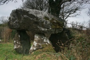
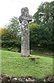
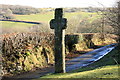
The remains of an incised cross stands at the foot of Lynch Hill, 200 yards south of Meavy Ford. In 1937, it was struck by a car and broken off at a point six inches below the surface. Excavation for re-erection revealed an irregular shaped socket-stone which was left uncovered when the cross was repaired. The cross was re-erected to a lower height than its original one.
You may be viewing yesterday's version of this page. To see the most up to date information please register for a free account.
Do not use the above information on other web sites or publications without permission of the contributor.
Nearby Images from Geograph Britain and Ireland:
©2019(licence)
©2021(licence)
©2021(licence)
©2009(licence)
©2021(licence)
The above images may not be of the site on this page, they are loaded from Geograph.
Please Submit an Image of this site or go out and take one for us!
Click here to see more info for this site
Nearby sites
Key: Red: member's photo, Blue: 3rd party photo, Yellow: other image, Green: no photo - please go there and take one, Grey: site destroyed
Download sites to:
KML (Google Earth)
GPX (GPS waypoints)
CSV (Garmin/Navman)
CSV (Excel)
To unlock full downloads you need to sign up as a Contributory Member. Otherwise downloads are limited to 50 sites.
Turn off the page maps and other distractions
Nearby sites listing. In the following links * = Image available
1.6km NE 56° Roman Cross (Sheepstor)* Ancient Cross (SX5595967653)
1.7km ENE 59° St Leonard's Well (Sheepstor)* Holy Well or Sacred Spring (SX5607467630)
1.7km ESE 120° Ringmoor Down Cairn 4* Ring Cairn (SX5610265907)
1.8km ESE 118° Ringmoor Down Cairn 3* Cairn (SX5615465937)
1.8km S 176° Wigford Down 9 Cairn (SX5469065050)
1.8km S 176° Wigford Down 4* Cairn (SX5469364969)
1.8km S 176° Wigford Down 5* Cairn (SX5470264962)
1.9km ESE 108° Ringmoor Down Stone Row* Multiple Stone Rows / Avenue (SX56416617)
2.0km ESE 119° Ringmoor Down stone circle* Stone Circle (SX56336581)
2.0km ESE 118° Ringmoor Down* Barrow Cemetery (SX56406580)
2.1km SE 139° Brisworthy Cup Stone* Rock Art (SX55986516)
2.2km SSE 161° Cadover Cross* Ancient Cross (SX553647)
2.2km ESE 117° Ringmoor Down Cairn 2* Cairn (SX56596576)
2.3km SE 124° Brisworthy* Stone Circle (SX5646765489)
2.3km ESE 123° Ringmoor Down Cairn 1* Cairn (SX56566549)
2.4km S 183° Wigford Down 1* Stone Circle (SX5442464421)
2.7km SE 131° Shadyback Tor settlement* Ancient Village or Settlement (SX566650)
2.9km SSW 193° Dewerstone* Causewayed Enclosure (SX53876399)
3.0km E 88° Gutter Tor South* Cist (SX5760966828)
3.0km ESE 119° Legis Tor Enclosures* Ancient Village or Settlement (SX572653)
3.0km ENE 69° Yellowmead* Stone Circle (SX57486784)
3.0km ENE 69° Yellowmead row* Multiple Stone Rows / Avenue (SX5748267842)
3.1km E 82° Gutter Tor north* Cairn (SX5767667137)
3.1km ESE 114° Legis Tor Cairns* Cist (SX57396548)
3.1km ENE 68° Yellowmead cairn* Cairn (SX5753167863)
View more nearby sites and additional images


 We would like to know more about this location. Please feel free to add a brief description and any relevant information in your own language.
 Wir möchten mehr über diese Stätte erfahren. Bitte zögern Sie nicht, eine kurze Beschreibung und relevante Informationen in Deutsch hinzuzufügen.
 Nous aimerions en savoir encore un peu sur les lieux. S'il vous plaît n'hesitez pas à ajouter une courte description et tous les renseignements pertinents dans votre propre langue.
 Quisieramos informarnos un poco más de las lugares. No dude en añadir una breve descripción y otros datos relevantes en su propio idioma.