

<< Our Photo Pages >> Merrivale Cists - Burial Chamber or Dolmen in England in Devon
Submitted by thecaptain on Saturday, 06 November 2004 Page Views: 8700
Neolithic and Bronze AgeSite Name: Merrivale Cists Alternative Name: Merrivale Cist 7; Butler (V3 44.8.7); Dixon 98; Grinsell Walkhampton 5Country: England County: Devon Type: Burial Chamber or Dolmen
Nearest Town: Princetown Nearest Village: Merrivale
Map Ref: SX5549074762
Latitude: 50.554705N Longitude: 4.041357W
Condition:
| 5 | Perfect |
| 4 | Almost Perfect |
| 3 | Reasonable but with some damage |
| 2 | Ruined but still recognisable as an ancient site |
| 1 | Pretty much destroyed, possibly visible as crop marks |
| 0 | No data. |
| -1 | Completely destroyed |
| 5 | Superb |
| 4 | Good |
| 3 | Ordinary |
| 2 | Not Good |
| 1 | Awful |
| 0 | No data. |
| 5 | Can be driven to, probably with disabled access |
| 4 | Short walk on a footpath |
| 3 | Requiring a bit more of a walk |
| 2 | A long walk |
| 1 | In the middle of nowhere, a nightmare to find |
| 0 | No data. |
| 5 | co-ordinates taken by GPS or official recorded co-ordinates |
| 4 | co-ordinates scaled from a detailed map |
| 3 | co-ordinates scaled from a bad map |
| 2 | co-ordinates of the nearest village |
| 1 | co-ordinates of the nearest town |
| 0 | no data |
Internal Links:
External Links:
I have visited· I would like to visit
KieKa would like to visit
lauraaurora visited on 6th Aug 2022 - their rating: Cond: 3 Amb: 5 Access: 4
lucasn visited on 27th Jun 2019 - their rating: Cond: 4 Amb: 4 Access: 4
Anne T visited on 14th May 2019 - their rating: Cond: 3 Amb: 4 Access: 4 Merrivale Cist: I've seen quite a few cists, largely in Northumberland, and none this large. Impressive. I tried to persuade Janet to get into the cist to model it, but she politely declined (it would have made a nice refuge for the wind).
At this point, Angie got her dowsing rods out and was meandering around the cist and the stones. Very interesting to watch.
markj99 visited on 28th Nov 2017 - their rating: Cond: 3 Amb: 4 Access: 3 The cist located S of the double stone rows has a very large split capstone. The cist was filled with water on my visit.
SandyG visited on 18th Oct 2014 - their rating: Cond: 3 Amb: 5 Access: 4
graemefield visited on 1st Jan 2008 - their rating: Cond: 3 Amb: 4 Access: 3
woodini254 visited on 15th Mar 1994 - their rating: Cond: 4 Amb: 5 Access: 4
TimPrevett AngieLake TheWhiteRider hamish TheCaptain cazzyjane have visited here
Average ratings for this site from all visit loggers: Condition: 3.29 Ambience: 4.43 Access: 3.71
")
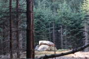
Just to the south of the Merrivale central avenue is a large Burial Cist with a broken capstone. The capstone has been split by stoneworkers a couple of centuries ago, with the middle part of it taken away for some other use, leaving us a view into the stone lined cist below.
There are many other burial cists in the Merrivale complex. This particular cist is recorded as Pastcape Monument No. 440050 and as part of Historic England List ID 1013429.
Butler, in Volume 3 of "Dartmoor Atlas of Antiquities", page 30, writes: "The cairn once covering the cist C7, at 2.2m long one of the largest on the moor, is now reduced to a slight bank around its western side … The cist was already exposed and no doubt emptied by the time of Bray’s visit in 1802 but otherwise seems to have been intact until 1870, when the huge cover slab was split across the centre to make a pair of gateposts, ‘by the occupants of the neighbouring public house’ according to Baring-Gould, and another was cut from the western side slab."
Update November 2019: This cist is also featured on the Prehistoric Dartmoor Walks (PDW) website - see their entries for the Merrivale Cist and the Merrivale Complex. This site is also recorded as MDV3738 (Cist and cairn south of stone alignment, Merrivale) on the Devon and Dartmoor HER.
You may be viewing yesterday's version of this page. To see the most up to date information please register for a free account.
")
")
")
")
")
")
")
")
")
")
")
")
")
")
")
")
")
")
")
")
")
")
")
")
")
These are just the first 25 photos of Merrivale Cists. If you log in with a free user account you will be able to see our entire collection.
Do not use the above information on other web sites or publications without permission of the contributor.
Click here to see more info for this site
Nearby sites
Key: Red: member's photo, Blue: 3rd party photo, Yellow: other image, Green: no photo - please go there and take one, Grey: site destroyed
Download sites to:
KML (Google Earth)
GPX (GPS waypoints)
CSV (Garmin/Navman)
CSV (Excel)
To unlock full downloads you need to sign up as a Contributory Member. Otherwise downloads are limited to 50 sites.
Turn off the page maps and other distractions
Nearby sites listing. In the following links * = Image available
13m NW 307° Merrivale* Multiple Stone Rows / Avenue (SX55487477)
49m WNW 303° Merrivale North Row* Multiple Stone Rows / Avenue (SX55457479)
60m W 276° Merrivale Centre N* Cairn (SX55437477)
69m NE 45° Merrivale NE circle* Stone Circle (SX55547481)
72m ENE 74° Merrivale Centre Row* Multiple Stone Rows / Avenue (SX55567478)
74m SSW 211° Merrivale Stone Slabs 1 and 2* Stone Row / Alignment (SX55457470)
90m W 274° Merrivale Centre S* Cairn (SX55407477)
96m W 268° Merrivale SW row 3* Stone Row / Alignment (SX5539474761)
182m WNW 294° Merrivale N circle* Stone Circle (SX5532674841)
190m W 265° Merrivale NW* Stone Circle (SX55307475)
192m SW 225° Merrivale circle* Stone Circle (SX55357463)
199m WSW 250° Cairn south of Stone Row B (Merrivale)* Cairn (SX553747)
209m SSW 213° Merrivale Second Menhir and Cairn* Standing Stone (Menhir) (SX55377459)
215m SW 215° Merrivale Menhir* Standing Stone (Menhir) (SX55367459)
221m SW 218° Merrivale 5* Stone Row / Alignment (SX5534974592)
221m SW 216° Merrivale row 4* Stone Row / Alignment (SX5535674586)
225m SW 219° Merrivale 6* Stone Row / Alignment (SX5534474590)
225m NNE 14° Merrivale settlement* Ancient Village or Settlement (SX5555174979)
909m ESE 108° Yellowmeade Farm* Cairn (SX56357446)
984m SSE 166° King's Tor* Rock Outcrop (SX557738)
1.3km WSW 252° Vixen Tor* Cist (SX5424074392)
1.8km NE 49° Mis Tor Farm Cairn (SX56927594)
2.1km WSW 255° Windy Post Cross* Ancient Cross (SX53437428)
2.2km W 264° Barn Hill Cairn (SX53337458)
2.2km NW 326° Roos Tor Rocks* Rock Outcrop (SX543766)
View more nearby sites and additional images


 We would like to know more about this location. Please feel free to add a brief description and any relevant information in your own language.
 Wir möchten mehr über diese Stätte erfahren. Bitte zögern Sie nicht, eine kurze Beschreibung und relevante Informationen in Deutsch hinzuzufügen.
 Nous aimerions en savoir encore un peu sur les lieux. S'il vous plaît n'hesitez pas à ajouter une courte description et tous les renseignements pertinents dans votre propre langue.
 Quisieramos informarnos un poco más de las lugares. No dude en añadir una breve descripción y otros datos relevantes en su propio idioma.