<< Our Photo Pages >> Shovel Down Fourfold Circle - Stone Circle in England in Devon
Submitted by Tom_Bullock on Saturday, 16 October 2004 Page Views: 9822
Neolithic and Bronze AgeSite Name: Shovel Down Fourfold Circle Alternative Name: Shovel Down SE; Grinsell Gidleigh 3; Turner G31; Butler (map 36.7)Country: England County: Devon Type: Stone Circle
Nearest Town: Chagford Nearest Village: Teigncombe
Map Ref: SX65958603 Landranger Map Number: 191
Latitude: 50.658475N Longitude: 3.897858W
Condition:
| 5 | Perfect |
| 4 | Almost Perfect |
| 3 | Reasonable but with some damage |
| 2 | Ruined but still recognisable as an ancient site |
| 1 | Pretty much destroyed, possibly visible as crop marks |
| 0 | No data. |
| -1 | Completely destroyed |
| 5 | Superb |
| 4 | Good |
| 3 | Ordinary |
| 2 | Not Good |
| 1 | Awful |
| 0 | No data. |
| 5 | Can be driven to, probably with disabled access |
| 4 | Short walk on a footpath |
| 3 | Requiring a bit more of a walk |
| 2 | A long walk |
| 1 | In the middle of nowhere, a nightmare to find |
| 0 | No data. |
| 5 | co-ordinates taken by GPS or official recorded co-ordinates |
| 4 | co-ordinates scaled from a detailed map |
| 3 | co-ordinates scaled from a bad map |
| 2 | co-ordinates of the nearest village |
| 1 | co-ordinates of the nearest town |
| 0 | no data |
Internal Links:
External Links:
I have visited· I would like to visit
Catrinm visited on 17th Sep 2023 - their rating: Cond: 3 Access: 3 Lovely little four fold circle
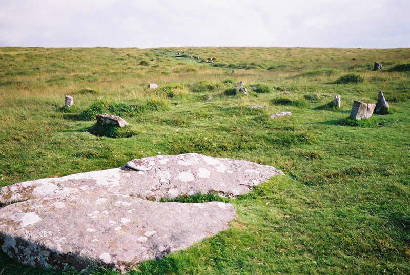
Anne T visited on 16th May 2019 - their rating: Cond: 3 Amb: 5 Access: 3 Shovel Down Fourfold Stone Circle: Again, so many monuments in such a short walk – but by now, I should have stopped being surprised! At Kes Tor, Sandy G had spotted AngieLake, who had arrived a little later than us at the car park, and who had wandered about looking for us. By this time, it was lunchtime, and we were pleased to re-group and sit and take a welcome break, using the two large stones as the head of row 2 as a convenient picnic spot.
Whilst everyone was sharing out their sandwiches and tea/coffee, I took a few minutes to try and photograph the small-ish stones of the fourfold stone circle, largely hidden by the grassy tussocks, but none-the-less still recognisable as a kerbed cairn, although a little similar (if smaller) than Yellowmead.
With its proximity to row 2 and row 4, and other rows and features I'd not yet seen, this was an amazing spot.
SandyG visited on 28th Apr 2013 - their rating: Cond: 4 Amb: 5 Access: 4
BolshieBoris visited on 1st Jan 2013 - their rating: Cond: 2 Amb: 3 Access: 3 Fair walk, long stone row with a small circle at the end, good views
jeffrep visited on 21st May 2011 - their rating: Cond: 3 Amb: 4 Access: 4
TheCaptain cazzyjane cazzyjane have visited here
Average ratings for this site from all visit loggers: Condition: 3 Ambience: 4.25 Access: 3.4

Circle diameter: 29 feet to 8 feet (inner), Number of stones: 10, 6, 8, 5 (inner)
This stone circle is recorded as Pastscape Monument No. 443527. It also features in the Prehistoric Dartmoor Walks website - see their entries for the Shovel Down Fourfold Circle Standing Stone, the Shovel Down Fourfold Cairn Circle and the Shovel Down Complex.
This monument is also recorded as MDV6158 (Fourfold circle on Shovel Down, Chagford) on the Devon and Dartmoor HER, and scheduled as part of Historic England List Entry No. 1017874 (The North Teign coaxial field system (western part) and associated later remains at Shovel Down, Stonetor Hill and Long Ridge).
Butler, in his "Dartmoor Atlas of Antiquities", volume 2, page 178, tells us: "The cairn at the uphill end (of row 2) is known as the Fourfold Circle from the four concentric rings of stones which surround the central pit. A slight rise within the outer ring is all that remains of the mound, most of the smaller stones from the body of the cairn having been carted away. The rings are elliptical rather than truly circular with the longer axis in the direction of the row. The outer ring has a diameter of about 9m and contains ten stones, the others six, eight and five stones respectively, though all have several gaps."
Update November 2019: This stone circle is also featured on the Stone Rows of Great Britain website, as part of their entry for Shoveldown 2, which includes photographs of this stone circle showing its relationship to the nearby stone row, plus a plan of the monuments at Shoveldown, showing their inter-relationships.
You may be viewing yesterday's version of this page. To see the most up to date information please register for a free account.


Do not use the above information on other web sites or publications without permission of the contributor.
Click here to see more info for this site
Nearby sites
Key: Red: member's photo, Blue: 3rd party photo, Yellow: other image, Green: no photo - please go there and take one, Grey: site destroyed
Download sites to:
KML (Google Earth)
GPX (GPS waypoints)
CSV (Garmin/Navman)
CSV (Excel)
To unlock full downloads you need to sign up as a Contributory Member. Otherwise downloads are limited to 50 sites.
Turn off the page maps and other distractions
Nearby sites listing. In the following links * = Image available
40m S 178° Shovel Down* Multiple Stone Rows / Avenue (SX65958599)
85m SSE 158° Shovel Down row 4* Multiple Stone Rows / Avenue (SX65988595)
143m NNW 334° Shovel Down row 3* Multiple Stone Rows / Avenue (SX65898616)
149m SSE 159° Shovel Down Cairn Row 4* Cairn (SX66008589)
170m N 359° Shovel Down row 2* Multiple Stone Rows / Avenue (SX65958620)
177m NNE 15° Shovel Down row 1* Stone Row / Alignment (SX660862)
198m SW 228° Shovel Down Settlement* Ancient Village or Settlement (SX658859)
214m NW 321° Shovel Down stone circle* Stone Circle (SX65828620)
231m SSE 161° Shovel Down row 5* Multiple Stone Rows / Avenue (SX66028581)
359m SSE 166° The Longstone (Shovel Down)* Standing Stone (Menhir) (SX66038568)
433m S 172° Shovel Down row 6* Multiple Stone Rows / Avenue (SX660856)
556m S 170° Three Boys* Standing Stone (Menhir) (SX66038548)
592m SSE 163° Thornworthy Corner North Cist (SX66118546)
631m ENE 65° Kes Tor Cairn* Cairn (SX6653286277)
632m S 174° Shovel Down row 7* Multiple Stone Rows / Avenue (SX660854)
648m ENE 66° Kes Tor Rock Basin* Natural Stone / Erratic / Other Natural Feature (SX66558628)
651m ENE 61° Kestor Settlement* Ancient Village or Settlement (SX66538633)
779m WSW 238° Stonetor Brookhead East Cist (SX65288563)
895m SW 230° Stonetor Hill Cairn Circle* Cairn (SX6525085470)
928m ENE 57° Modern Stone Circle near Kestor Rock* Modern Stone Circle etc (SX66748652)
930m NNE 27° The Round Pound* Ancient Village or Settlement (SX66398685)
1.0km SW 227° Stonetor Hill Stone Ring Cairn Circle Ring Cairn (SX65198535)
1.1km NNW 335° The Tolmen Stone (Dartmoor)* Natural Stone / Erratic / Other Natural Feature (SX65508708)
1.2km SE 142° Thornworthy Down Stone Row / Alignment (SX66688505)
1.3km NNW 337° Scorhill Cairn and Rows* Multiple Stone Rows / Avenue (SX65488721)
View more nearby sites and additional images


 We would like to know more about this location. Please feel free to add a brief description and any relevant information in your own language.
 Wir möchten mehr über diese Stätte erfahren. Bitte zögern Sie nicht, eine kurze Beschreibung und relevante Informationen in Deutsch hinzuzufügen.
 Nous aimerions en savoir encore un peu sur les lieux. S'il vous plaît n'hesitez pas à ajouter une courte description et tous les renseignements pertinents dans votre propre langue.
 Quisieramos informarnos un poco más de las lugares. No dude en añadir una breve descripción y otros datos relevantes en su propio idioma.