

<< Our Photo Pages >> Fernworthy Cairn 4 - Cairn in England in Devon
Submitted by theCaptain on Monday, 16 June 2014 Page Views: 1491
Neolithic and Bronze AgeSite Name: Fernworthy Cairn 4 Alternative Name: Fernworthy 4D; Grinsell Lydford 22; Newman Barrow CCountry: England County: Devon Type: Cairn
Nearest Town: Chagford
Map Ref: SX65518403
Latitude: 50.640398N Longitude: 3.903352W
Condition:
| 5 | Perfect |
| 4 | Almost Perfect |
| 3 | Reasonable but with some damage |
| 2 | Ruined but still recognisable as an ancient site |
| 1 | Pretty much destroyed, possibly visible as crop marks |
| 0 | No data. |
| -1 | Completely destroyed |
| 5 | Superb |
| 4 | Good |
| 3 | Ordinary |
| 2 | Not Good |
| 1 | Awful |
| 0 | No data. |
| 5 | Can be driven to, probably with disabled access |
| 4 | Short walk on a footpath |
| 3 | Requiring a bit more of a walk |
| 2 | A long walk |
| 1 | In the middle of nowhere, a nightmare to find |
| 0 | No data. |
| 5 | co-ordinates taken by GPS or official recorded co-ordinates |
| 4 | co-ordinates scaled from a detailed map |
| 3 | co-ordinates scaled from a bad map |
| 2 | co-ordinates of the nearest village |
| 1 | co-ordinates of the nearest town |
| 0 | no data |
Internal Links:
External Links:
I have visited· I would like to visit
TheCaptain has visited here
")
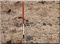
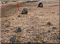
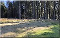
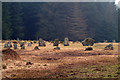
Probably about 10 metres in diameter, the centre of the cairn is green and rocky, and there are several kerbstones making up a circular surround.
Update October 2019: This barrow is featured on the Prehistoric Dartmoor Walks (PDW) website - see their entry for the Fernworthy Barrow C Cairn, which tells us this forms part of the "ceremonial complex at Froggymeade. It is sited at the southern end of the eastern stone row to the south of the Fernworthy stone circle. It was excavated in 1898, but had previously been disturbed".
This site is also recorded as part of Pastscape Monument No. 443898, which includes the following sites: "(a) Bronze Age cairn, barrow containing a cist, and double stone row between the two". The Devon and Dartmoor HER also includes an entry for this cairn; see MDV14887 (Cairn at southern end of stone row at Fernworthy).
The cairn is also scheduled as part of Historic England List ID 1017984 (A stone circle, known as Fernworthy Circle, three stone alignments and five cairns 425m and 525m north west of Sandeman Bridge).
You may be viewing yesterday's version of this page. To see the most up to date information please register for a free account.
")
")
Do not use the above information on other web sites or publications without permission of the contributor.
Nearby Images from Geograph Britain and Ireland:
©2020(licence)
©2020(licence)
©2020(licence)
©2020(licence)
©2006(licence)
The above images may not be of the site on this page, they are loaded from Geograph.
Please Submit an Image of this site or go out and take one for us!
Click here to see more info for this site
Nearby sites
Key: Red: member's photo, Blue: 3rd party photo, Yellow: other image, Green: no photo - please go there and take one, Grey: site destroyed
Download sites to:
KML (Google Earth)
GPX (GPS waypoints)
CSV (Garmin/Navman)
CSV (Excel)
To unlock full downloads you need to sign up as a Contributory Member. Otherwise downloads are limited to 50 sites.
Turn off the page maps and other distractions
Nearby sites listing. In the following links * = Image available
45m NNW 332° Fernworthy stone row SE* Stone Row / Alignment (SX65498407)
63m NNW 340° Fernworthy Cairn SE* Cairn (SX65498409)
64m NE 50° Fernworthy Cairn E* Cairn (SX65568407)
76m NNW 335° Fernworthy* Multiple Stone Rows / Avenue (SX65488410)
81m NNW 329° Fernworthy Cairn SW* Cairn (SX65478410)
81m NNW 336° Fernworthy stone row SW* Multiple Stone Rows / Avenue (SX6547984105)
85m NNW 338° Fernworthy circle* Stone Circle (SX65488411)
301m N 4° Fernworthy Cairn N* Cairn (SX65548433)
307m N 4° Fernworthy stone row N* Multiple Stone Rows / Avenue (SX6553884336)
612m W 275° Froggymead Settlement* Ancient Village or Settlement (SX649841)
680m WSW 253° Hemstone Rocks Ring Cairn and Cist* Cairn (SX6485283850)
689m WSW 250° Hemstone Rocks Platform Cairn Circle* Cairn (SX6485683806)
741m WSW 249° Fernworthy settlement* Ancient Village or Settlement (SX6481183777)
1.0km SE 127° Lowton Brook West Settlement* Ancient Village or Settlement (SX663834)
1.1km ESE 108° East Lowton settlement* Ancient Village or Settlement (SX6653783668)
1.3km ENE 75° Thornworthy Cairn* Cairn (SX6674284335)
1.3km E 89° Metherall Settlement* Ancient Village or Settlement (SX66838401)
1.4km NNW 345° Stonetor Hill Stone Ring Cairn Circle Ring Cairn (SX65198535)
1.5km NNE 18° Shovel Down row 7* Multiple Stone Rows / Avenue (SX660854)
1.5km NNW 348° Stonetor Hill Cairn Circle* Cairn (SX6525085470)
1.5km SSE 156° Assycombe Hill* Cairn (SX66108264)
1.5km SSE 158° Assycombe* Multiple Stone Rows / Avenue (SX66058260)
1.5km NNE 18° Three Boys* Standing Stone (Menhir) (SX66038548)
1.5km NE 47° Thornworthy Down Stone Row / Alignment (SX66688505)
1.5km NNE 21° Thornworthy Corner North Cist (SX66118546)
View more nearby sites and additional images


 We would like to know more about this location. Please feel free to add a brief description and any relevant information in your own language.
 Wir möchten mehr über diese Stätte erfahren. Bitte zögern Sie nicht, eine kurze Beschreibung und relevante Informationen in Deutsch hinzuzufügen.
 Nous aimerions en savoir encore un peu sur les lieux. S'il vous plaît n'hesitez pas à ajouter une courte description et tous les renseignements pertinents dans votre propre langue.
 Quisieramos informarnos un poco más de las lugares. No dude en añadir una breve descripción y otros datos relevantes en su propio idioma.