


<< Our Photo Pages >> White Ridge pound - Ring Cairn in England in Devon
Submitted by theCaptain on Monday, 16 June 2014 Page Views: 2026
Neolithic and Bronze AgeSite Name: White Ridge pound Alternative Name: South Teignhead Pound; Whie Ridge; Teignhead Henge; Turner A5; Butler (map 35.18)Country: England County: Devon Type: Ring Cairn
Nearest Town: Chagford
Map Ref: SX6416882656
Latitude: 50.627737N Longitude: 3.921816W
Condition:
| 5 | Perfect |
| 4 | Almost Perfect |
| 3 | Reasonable but with some damage |
| 2 | Ruined but still recognisable as an ancient site |
| 1 | Pretty much destroyed, possibly visible as crop marks |
| 0 | No data. |
| -1 | Completely destroyed |
| 5 | Superb |
| 4 | Good |
| 3 | Ordinary |
| 2 | Not Good |
| 1 | Awful |
| 0 | No data. |
| 5 | Can be driven to, probably with disabled access |
| 4 | Short walk on a footpath |
| 3 | Requiring a bit more of a walk |
| 2 | A long walk |
| 1 | In the middle of nowhere, a nightmare to find |
| 0 | No data. |
| 5 | co-ordinates taken by GPS or official recorded co-ordinates |
| 4 | co-ordinates scaled from a detailed map |
| 3 | co-ordinates scaled from a bad map |
| 2 | co-ordinates of the nearest village |
| 1 | co-ordinates of the nearest town |
| 0 | no data |
Internal Links:
External Links:
I have visited· I would like to visit
graemefield visited on 28th Feb 2017 - their rating: Cond: 2 Amb: 4 Access: 1
TheCaptain have visited here
")
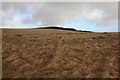
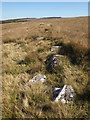
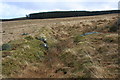
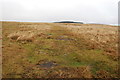
This one is between 20 and 25 metred in diameter, surrounded by an embanked rubble wall up to a metre in height, and with an entrance on the western side still with a jamb in place, at which point the walls are easiest to see.
There is a large elongated slab near to the middle of the structure, which looks to me like it should once have been standing.
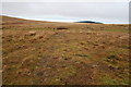
I tried to walk directly between the two enclosures, but do not recommend it, as I ended up knee deep in a very wet and squelchy bog.
Update December 2019: Pastscape Monument No. 443925 tells us that this enclosure has now been identified as a ring cairn. It is also included as MDV6754 (Pound 320 metres south-east of the Grey Wethers stone circles) on the Devon and Dartmoor HER, and scheduled as part of Historic England List Entry No. 1018707 (Two stone circles known as The Grey Wethers, three round cairns, two ring cairns and an oval enclosure in Great Stannon Newtake).
The cairn is also featured on the Prehistoric Dartmoor Walks (PDW website - see their entry for the South Teignhead / White Ridge Stone Ring Cairn Circle.
You may be viewing yesterday's version of this page. To see the most up to date information please register for a free account.
")
")
Do not use the above information on other web sites or publications without permission of the contributor.
Nearby Images from Geograph Britain and Ireland:
©2010(licence)
©2013(licence)
©2019(licence)
©2010(licence)
©2013(licence)
The above images may not be of the site on this page, they are loaded from Geograph.
Please Submit an Image of this site or go out and take one for us!
Click here to see more info for this site
Nearby sites
Key: Red: member's photo, Blue: 3rd party photo, Yellow: other image, Green: no photo - please go there and take one, Grey: site destroyed
Download sites to:
KML (Google Earth)
GPX (GPS waypoints)
CSV (Garmin/Navman)
CSV (Excel)
To unlock full downloads you need to sign up as a Contributory Member. Otherwise downloads are limited to 50 sites.
Turn off the page maps and other distractions
Nearby sites listing. In the following links * = Image available
7m WSW 242° White Ridge Standing Stone* Standing Stone (Menhir) (SX6416282653)
169m SW 234° Sittaford Marsh Hut Circles* Ancient Village or Settlement (SX6402982560)
204m NNW 333° South Teignhead* Cairn (SX64088284)
274m NW 323° Sittaford Tor pound* Misc. Earthwork (SX64018288)
559m NNW 326° Grey Wethers.* Stone Circle (SX63878313)
705m W 268° Sittaford Tor Cairn* Cairn (SX6346182650)
850m S 173° White Ridge SW settlements* Ancient Village or Settlement (SX64258181)
974m ESE 118° White Ridge cairn* Round Cairn (SX65028218)
1.0km S 180° White Ridge SW cairn* Round Cairn (SX64158162)
1.2km W 276° Sittaford Stone Circle* Stone Circle (SX63018281)
1.2km S 190° Lade Hill Brook Beehive Hut* Ancient Mine, Quarry or other Industry (SX63938145)
1.3km NNE 28° Fernworthy settlement* Ancient Village or Settlement (SX6481183777)
1.3km NNE 29° Hemstone Rocks Platform Cairn Circle* Cairn (SX6485683806)
1.4km NNE 28° Hemstone Rocks Ring Cairn and Cist* Cairn (SX6485283850)
1.6km NNE 25° Froggymead Settlement* Ancient Village or Settlement (SX649841)
1.6km SE 130° White Ridge stone row* Stone Row / Alignment (SX65408156)
1.9km E 90° Assycombe* Multiple Stone Rows / Avenue (SX66058260)
1.9km NE 43° Fernworthy Cairn 4* Cairn (SX65518403)
1.9km E 89° Assycombe Hill* Cairn (SX66108264)
1.9km NE 42° Fernworthy stone row SE* Stone Row / Alignment (SX65498407)
1.9km SE 142° Stannon Newtake West Cairn and row* Multiple Stone Rows / Avenue (SX65338110)
1.9km NE 40° Fernworthy Cairn SW* Cairn (SX65478410)
1.9km NE 41° Fernworthy Cairn SE* Cairn (SX65498409)
1.9km NE 41° Fernworthy* Multiple Stone Rows / Avenue (SX65488410)
2.0km NE 41° Fernworthy stone row SW* Multiple Stone Rows / Avenue (SX6547984105)
View more nearby sites and additional images


 We would like to know more about this location. Please feel free to add a brief description and any relevant information in your own language.
 Wir möchten mehr über diese Stätte erfahren. Bitte zögern Sie nicht, eine kurze Beschreibung und relevante Informationen in Deutsch hinzuzufügen.
 Nous aimerions en savoir encore un peu sur les lieux. S'il vous plaît n'hesitez pas à ajouter une courte description et tous les renseignements pertinents dans votre propre langue.
 Quisieramos informarnos un poco más de las lugares. No dude en añadir una breve descripción y otros datos relevantes en su propio idioma.