<< Our Photo Pages >> Twll yr Ogof - Cairn in Wales in Gwynedd
Submitted by Postman on Saturday, 13 October 2012 Page Views: 2891
Neolithic and Bronze AgeSite Name: Twll yr Ogof Alternative Name: Carnedd Lwyd / Moel Gallt / Craig y Llyn.Country: Wales
NOTE: This site is 1.1 km away from the location you searched for.
County: Gwynedd Type: Cairn
Nearest Town: Barmouth Nearest Village: Llanfihangal-y-pennant
Map Ref: SH65961140
Latitude: 52.683661N Longitude: 3.984328W
Condition:
| 5 | Perfect |
| 4 | Almost Perfect |
| 3 | Reasonable but with some damage |
| 2 | Ruined but still recognisable as an ancient site |
| 1 | Pretty much destroyed, possibly visible as crop marks |
| 0 | No data. |
| -1 | Completely destroyed |
| 5 | Superb |
| 4 | Good |
| 3 | Ordinary |
| 2 | Not Good |
| 1 | Awful |
| 0 | No data. |
| 5 | Can be driven to, probably with disabled access |
| 4 | Short walk on a footpath |
| 3 | Requiring a bit more of a walk |
| 2 | A long walk |
| 1 | In the middle of nowhere, a nightmare to find |
| 0 | No data. |
| 5 | co-ordinates taken by GPS or official recorded co-ordinates |
| 4 | co-ordinates scaled from a detailed map |
| 3 | co-ordinates scaled from a bad map |
| 2 | co-ordinates of the nearest village |
| 1 | co-ordinates of the nearest town |
| 0 | no data |
Internal Links:
External Links:
")
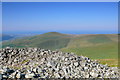
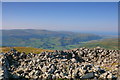
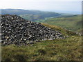
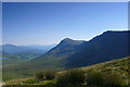
Parking: Drive north straight past Castell y Bere, a couple of gates need to be opened and closed, just drive as far as you can then the long up hill walk west begins. The dishevelled cairn is next to a wall made from the cairn, no doubt. The natural ground surface has been exposed in the central scoop. A bit misty in the south on my trip, but the early morning sun shone upon it and everything seemed to be gleaming and gorgeous.
You may be viewing yesterday's version of this page. To see the most up to date information please register for a free account.
")
")
Do not use the above information on other web sites or publications without permission of the contributor.
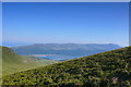
Nearby Images from Geograph Britain and Ireland:
©2014(licence)
©2014(licence)
©2011(licence)
©2014(licence)
©2014(licence)
The above images may not be of the site on this page, they are loaded from Geograph.
Please Submit an Image of this site or go out and take one for us!
Click here to see more info for this site
Nearby sites
Key: Red: member's photo, Blue: 3rd party photo, Yellow: other image, Green: no photo - please go there and take one, Grey: site destroyed
Download sites to:
KML (Google Earth)
GPX (GPS waypoints)
CSV (Garmin/Navman)
CSV (Excel)
To unlock full downloads you need to sign up as a Contributory Member. Otherwise downloads are limited to 50 sites.
Turn off the page maps and other distractions
Nearby sites listing. In the following links * = Image available
1.8km NNW 347° Afon Arthog Standing Stone* Standing Stone (Menhir) (SH6561013120)
1.9km N 1° Afon Arthog Cairns* Cairn (SH66061326)
1.9km NNW 348° Cairn South of Ffordd Ddu* Round Cairn (SH656133)
2.0km NNE 12° Cairn East of Hafotty Fach* Cairn (SH66441332)
2.0km N 356° Hafotty Arthog Cairn* Cairn (SH6588713401)
2.0km NNW 335° Planwydd Helyg Standing Stone* Standing Stone (Menhir) (SH65161325)
2.1km N 2° Hafotty Fach gate menhirs* Standing Stones (SH66091349)
2.1km N 3° Hafotty Fach Cockpit Cairn* Cairn (SH6612013490)
2.1km N 10° Hafoty-Fach cairns* Round Cairn (SH664135)
2.2km NNE 19° Hafotty Fach monolith quarry* Ancient Mine, Quarry or other Industry (SH66721342)
2.2km NNE 19° Settlement East of Tyrrau Mawr* Ancient Village or Settlement (SH6674013500)
2.3km NNE 20° Graig Las Cairn* Cairn (SH6680013500)
2.3km N 355° Cairn Cemetery North of Hafotty Fach* Barrow Cemetery (SH65811366)
2.3km N 10° Rhos Hafotty Carneddau* Standing Stones (SH6642213627)
2.3km NNE 14° Rhos Hafotty Carneddau stone setting* Standing Stones (SH66591362)
2.3km NNE 14° Hafotty Fach Monument* Cairn (SH6658913627)
2.3km NNW 339° Burial Cairn South of Eglwys Foel* Cairn (SH652136)
2.4km NNE 20° Graig Las Cairn 2* Cairn (SH6682913598)
2.4km NNE 22° Graig Las Hut Circle* Ancient Village or Settlement (SH6690013570)
2.4km NNE 20° Graig Las Round Cairn* Round Cairn (SH6683013600)
2.4km WNW 283° Braich Ddu Cairn Cemetery* Barrow Cemetery (SH6362012020)
2.4km N 3° Carreg y Big (Arthog)* Standing Stone (Menhir) (SH66171384)
2.5km N 11° Llynnau Cregennen Cairns* Cairn (SH665138)
2.5km N 350° Hafotty Quartz Cairns* Cairn (SH6559413870)
2.5km W 270° Bedd-y-brenin* Cairn (SH6343811484)
View more nearby sites and additional images


 We would like to know more about this location. Please feel free to add a brief description and any relevant information in your own language.
 Wir möchten mehr über diese Stätte erfahren. Bitte zögern Sie nicht, eine kurze Beschreibung und relevante Informationen in Deutsch hinzuzufügen.
 Nous aimerions en savoir encore un peu sur les lieux. S'il vous plaît n'hesitez pas à ajouter une courte description et tous les renseignements pertinents dans votre propre langue.
 Quisieramos informarnos un poco más de las lugares. No dude en añadir una breve descripción y otros datos relevantes en su propio idioma.