

<< Our Photo Pages >> Settlement East of Tyrrau Mawr - Ancient Village or Settlement in Wales in Gwynedd
Submitted by TAlanJones on Saturday, 19 March 2022 Page Views: 376
Multi-periodSite Name: Settlement East of Tyrrau MawrCountry: Wales County: Gwynedd Type: Ancient Village or Settlement
Nearest Town: Dolgellau Nearest Village: Arthog
Map Ref: SH6674013500
Latitude: 52.702721N Longitude: 3.973647W
Condition:
| 5 | Perfect |
| 4 | Almost Perfect |
| 3 | Reasonable but with some damage |
| 2 | Ruined but still recognisable as an ancient site |
| 1 | Pretty much destroyed, possibly visible as crop marks |
| 0 | No data. |
| -1 | Completely destroyed |
| 5 | Superb |
| 4 | Good |
| 3 | Ordinary |
| 2 | Not Good |
| 1 | Awful |
| 0 | No data. |
| 5 | Can be driven to, probably with disabled access |
| 4 | Short walk on a footpath |
| 3 | Requiring a bit more of a walk |
| 2 | A long walk |
| 1 | In the middle of nowhere, a nightmare to find |
| 0 | No data. |
| 5 | co-ordinates taken by GPS or official recorded co-ordinates |
| 4 | co-ordinates scaled from a detailed map |
| 3 | co-ordinates scaled from a bad map |
| 2 | co-ordinates of the nearest village |
| 1 | co-ordinates of the nearest town |
| 0 | no data |
Internal Links:
External Links:
I have visited· I would like to visit
Geraint1 visited on 27th Mar 2024 - their rating: Cond: 2 Amb: 5 Access: 2
")
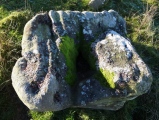
The settlement is situated on a raised level that is to the east of a narrow country lane that leads to the Cregennen lakes. The settlement is visible from the lane but there is limited parking should you wish to visit the site.
The site comprises of a Large enclosure (17m diameter) that has a hut circle on its south side. However, a later ruined dwelling with associated field systems lies about 30m to the north east.
The site has extensive views along the valley that leads down to Dolgellau, and of the surrounding mountains.
You may be viewing yesterday's version of this page. To see the most up to date information please register for a free account.
")
")
")
")
")
")
")
")
")
Do not use the above information on other web sites or publications without permission of the contributor.
Click here to see more info for this site
Nearby sites
Key: Red: member's photo, Blue: 3rd party photo, Yellow: other image, Green: no photo - please go there and take one, Grey: site destroyed
Download sites to:
KML (Google Earth)
GPX (GPS waypoints)
CSV (Garmin/Navman)
CSV (Excel)
To unlock full downloads you need to sign up as a Contributory Member. Otherwise downloads are limited to 50 sites.
Turn off the page maps and other distractions
Nearby sites listing. In the following links * = Image available
60m E 88° Graig Las Cairn* Cairn (SH6680013500)
82m SSW 192° Hafotty Fach monolith quarry* Ancient Mine, Quarry or other Industry (SH66721342)
132m NE 41° Graig Las Cairn 2* Cairn (SH6682913598)
134m NE 40° Graig Las Round Cairn* Round Cairn (SH6683013600)
174m ENE 65° Graig Las Hut Circle* Ancient Village or Settlement (SH6690013570)
192m NW 307° Rhos Hafotty Carneddau stone setting* Standing Stones (SH66591362)
197m NW 309° Hafotty Fach Monument* Cairn (SH6658913627)
339m W 268° Hafoty-Fach cairns* Round Cairn (SH664135)
341m WNW 290° Rhos Hafotty Carneddau* Standing Stones (SH6642213627)
349m WSW 237° Cairn East of Hafotty Fach* Cairn (SH66441332)
384m NW 320° Llynnau Cregennen Cairns* Cairn (SH665138)
618m W 267° Hafotty Fach Cockpit Cairn* Cairn (SH6612013490)
648m W 268° Hafotty Fach gate menhirs* Standing Stones (SH66091349)
662m WNW 299° Carreg y Big (Arthog)* Standing Stone (Menhir) (SH66171384)
719m WSW 249° Afon Arthog Cairns* Cairn (SH66061326)
806m WNW 300° Carreg y Pwyso* Standing Stone (Menhir) (SH66051392)
941m W 278° Cairn Cemetery North of Hafotty Fach* Barrow Cemetery (SH65811366)
1.2km WSW 258° Cairn South of Ffordd Ddu* Round Cairn (SH656133)
1.2km WSW 250° Afon Arthog Standing Stone* Standing Stone (Menhir) (SH6561013120)
1.3km NW 320° Cregennen standing stone* Standing Stone (Menhir) (SH65941450)
1.4km N 353° Hut Circle South of Pared Y Cefn hir* Ancient Village or Settlement (SH666149)
1.4km NW 318° Llynnau Cregennau Cairn* Cairn (SH6582114574)
1.5km E 88° Tyrrau Mawr* Cairn (SH68281352)
1.5km WNW 285° Arthog Standing Stones* Stone Circle (SH65261393)
1.5km W 272° Burial Cairn South of Eglwys Foel* Cairn (SH652136)
View more nearby sites and additional images


 We would like to know more about this location. Please feel free to add a brief description and any relevant information in your own language.
 Wir möchten mehr über diese Stätte erfahren. Bitte zögern Sie nicht, eine kurze Beschreibung und relevante Informationen in Deutsch hinzuzufügen.
 Nous aimerions en savoir encore un peu sur les lieux. S'il vous plaît n'hesitez pas à ajouter une courte description et tous les renseignements pertinents dans votre propre langue.
 Quisieramos informarnos un poco más de las lugares. No dude en añadir una breve descripción y otros datos relevantes en su propio idioma.