 with our Megalithic Portal iPhone app")


<< Our Photo Pages >> Llynnau Cregennau Cairn - Cairn in Wales in Gwynedd
Submitted by TAlanJones on Thursday, 04 April 2024 Page Views: 42
Neolithic and Bronze AgeSite Name: Llynnau Cregennau CairnCountry: Wales County: Gwynedd Type: Cairn
Nearest Town: Dolgellau Nearest Village: Arthog
Map Ref: SH6582114574
Latitude: 52.712142N Longitude: 3.987678W
Condition:
| 5 | Perfect |
| 4 | Almost Perfect |
| 3 | Reasonable but with some damage |
| 2 | Ruined but still recognisable as an ancient site |
| 1 | Pretty much destroyed, possibly visible as crop marks |
| 0 | No data. |
| -1 | Completely destroyed |
| 5 | Superb |
| 4 | Good |
| 3 | Ordinary |
| 2 | Not Good |
| 1 | Awful |
| 0 | No data. |
| 5 | Can be driven to, probably with disabled access |
| 4 | Short walk on a footpath |
| 3 | Requiring a bit more of a walk |
| 2 | A long walk |
| 1 | In the middle of nowhere, a nightmare to find |
| 0 | No data. |
| 5 | co-ordinates taken by GPS or official recorded co-ordinates |
| 4 | co-ordinates scaled from a detailed map |
| 3 | co-ordinates scaled from a bad map |
| 2 | co-ordinates of the nearest village |
| 1 | co-ordinates of the nearest town |
| 0 | no data |
Internal Links:
External Links:
")
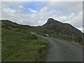
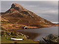
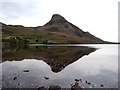
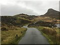
Situated to the north of Llynnau Cregennau the cairn lies a few metres north of the narrow road that leads from the lakes to Arthog. This is an area that attracts visitors and there is a car park close to the most northerly lake. The cairn is just a short walk from there.
The cairn does not attract much attention yet it is quite a feature at the side pf the road. It has a 5m slightly raised diameter consisting of earth and stone with some large boulders mainly on the western side. The interior has been disturbed forming an almos square hole (1.5m) currently overgrown with marsh grass.
Coflein has recorded the cairn as NPRN 780.
You may be viewing yesterday's version of this page. To see the most up to date information please register for a free account.
")
")
")
")
Do not use the above information on other web sites or publications without permission of the contributor.
Nearby Images from Geograph Britain and Ireland:

©2009(licence)
©2023(licence)
©2012(licence)
©2013(licence)
©2024(licence)
The above images may not be of the site on this page, they are loaded from Geograph.
Please Submit an Image of this site or go out and take one for us!
Click here to see more info for this site
Nearby sites
Key: Red: member's photo, Blue: 3rd party photo, Yellow: other image, Green: no photo - please go there and take one, Grey: site destroyed
Download sites to:
KML (Google Earth)
GPX (GPS waypoints)
CSV (Garmin/Navman)
CSV (Excel)
To unlock full downloads you need to sign up as a Contributory Member. Otherwise downloads are limited to 50 sites.
Turn off the page maps and other distractions
Nearby sites listing. In the following links * = Image available
140m ESE 120° Cregennen standing stone* Standing Stone (Menhir) (SH65941450)
295m WNW 300° Cefn Hir Uchaf Cairn* Cairn (SH6557014730)
692m SSE 159° Carreg y Pwyso* Standing Stone (Menhir) (SH66051392)
812m SSE 153° Carreg y Big (Arthog)* Standing Stone (Menhir) (SH66171384)
842m ENE 66° Hut Circle South of Pared Y Cefn hir* Ancient Village or Settlement (SH666149)
844m SW 222° Standing Stone West of The Arthog Standing Stones* Standing Stone (Menhir) (SH65241396)
853m SW 219° Arthog Standing Stones* Stone Circle (SH65261393)
857m NE 51° Pared-y-Cefn-Hir* Hillfort (SH665151)
914m S 179° Cairn Cemetery North of Hafotty Fach* Barrow Cemetery (SH65811366)
1.0km SE 137° Llynnau Cregennen Cairns* Cairn (SH665138)
1.1km ENE 60° Cairn South of Pared Y Cefn Hir* Cairn (SH668151)
1.1km SSE 165° Hafotty Fach gate menhirs* Standing Stones (SH66091349)
1.1km SE 146° Rhos Hafotty Carneddau* Standing Stones (SH6642213627)
1.1km SSE 163° Hafotty Fach Cockpit Cairn* Cairn (SH6612013490)
1.2km SSW 211° Burial Cairn South of Eglwys Foel* Cairn (SH652136)
1.2km SE 139° Hafotty Fach Monument* Cairn (SH6658913627)
1.2km SSE 150° Hafoty-Fach cairns* Round Cairn (SH664135)
1.2km SE 140° Rhos Hafotty Carneddau stone setting* Standing Stones (SH66591362)
1.3km S 188° Cairn South of Ffordd Ddu* Round Cairn (SH656133)
1.3km SSE 168° Afon Arthog Cairns* Cairn (SH66061326)
1.4km SSE 152° Cairn East of Hafotty Fach* Cairn (SH66441332)
1.4km SE 132° Graig Las Round Cairn* Round Cairn (SH6683013600)
1.4km SE 133° Graig Las Cairn 2* Cairn (SH6682913598)
1.4km SE 138° Settlement East of Tyrrau Mawr* Ancient Village or Settlement (SH6674013500)
1.5km SE 136° Graig Las Cairn* Cairn (SH6680013500)
View more nearby sites and additional images


 We would like to know more about this location. Please feel free to add a brief description and any relevant information in your own language.
 Wir möchten mehr über diese Stätte erfahren. Bitte zögern Sie nicht, eine kurze Beschreibung und relevante Informationen in Deutsch hinzuzufügen.
 Nous aimerions en savoir encore un peu sur les lieux. S'il vous plaît n'hesitez pas à ajouter une courte description et tous les renseignements pertinents dans votre propre langue.
 Quisieramos informarnos un poco más de las lugares. No dude en añadir una breve descripción y otros datos relevantes en su propio idioma.