

<< Our Photo Pages >> Cairn Cemetery North of Hafotty Fach - Barrow Cemetery in Wales in Gwynedd
Submitted by TAlanJones on Thursday, 10 March 2022 Page Views: 585
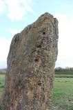
Neolithic and Bronze AgeSite Name: Cairn Cemetery North of Hafotty FachCountry: Wales County: Gwynedd Type: Barrow Cemetery
Nearest Town: Dolgellau Nearest Village: Arthog
Map Ref: SH65811366
Latitude: 52.703928N Longitude: 3.987467W
Condition:
| 5 | Perfect |
| 4 | Almost Perfect |
| 3 | Reasonable but with some damage |
| 2 | Ruined but still recognisable as an ancient site |
| 1 | Pretty much destroyed, possibly visible as crop marks |
| 0 | No data. |
| -1 | Completely destroyed |
| 5 | Superb |
| 4 | Good |
| 3 | Ordinary |
| 2 | Not Good |
| 1 | Awful |
| 0 | No data. |
| 5 | Can be driven to, probably with disabled access |
| 4 | Short walk on a footpath |
| 3 | Requiring a bit more of a walk |
| 2 | A long walk |
| 1 | In the middle of nowhere, a nightmare to find |
| 0 | No data. |
| 5 | co-ordinates taken by GPS or official recorded co-ordinates |
| 4 | co-ordinates scaled from a detailed map |
| 3 | co-ordinates scaled from a bad map |
| 2 | co-ordinates of the nearest village |
| 1 | co-ordinates of the nearest town |
| 0 | no data |
Internal Links:
External Links:
")
Situated in a south westerly sloping field this site offers a wee poser. There are multiple stone cairns holding claim to at least half the field. Now it may be that they are all clearance cairns that have remained unattended to for decades? However, when examined closely some resemble funerary cairns, similar in size and shape to identified cairns, occasionally with hollowed centres? Not that convincing perhaps, but when you consider that there are fields in Gwynedd where funerary cairns lie surrounded by clearance cairns, and add to that the numerous recorded cairns that lie locally, in all directions and in close proximity to this field it does beg the question 'were/are some of these funerary cairns?'
You may be viewing yesterday's version of this page. To see the most up to date information please register for a free account.
")
")
")
")
")
")
")
Do not use the above information on other web sites or publications without permission of the contributor.
Click here to see more info for this site
Nearby sites
Key: Red: member's photo, Blue: 3rd party photo, Yellow: other image, Green: no photo - please go there and take one, Grey: site destroyed
Download sites to:
KML (Google Earth)
GPX (GPS waypoints)
CSV (Garmin/Navman)
CSV (Excel)
To unlock full downloads you need to sign up as a Contributory Member. Otherwise downloads are limited to 50 sites.
Turn off the page maps and other distractions
Nearby sites listing. In the following links * = Image available
327m ESE 120° Hafotty Fach gate menhirs* Standing Stones (SH66091349)
353m ESE 117° Hafotty Fach Cockpit Cairn* Cairn (SH6612013490)
353m NE 41° Carreg y Pwyso* Standing Stone (Menhir) (SH66051392)
401m ENE 62° Carreg y Big (Arthog)* Standing Stone (Menhir) (SH66171384)
416m SSW 209° Cairn South of Ffordd Ddu* Round Cairn (SH656133)
471m SSE 146° Afon Arthog Cairns* Cairn (SH66061326)
575m SSW 199° Afon Arthog Standing Stone* Standing Stone (Menhir) (SH6561013120)
610m ESE 104° Hafoty-Fach cairns* Round Cairn (SH664135)
611m E 92° Rhos Hafotty Carneddau* Standing Stones (SH6642213627)
611m WNW 295° Arthog Standing Stones* Stone Circle (SH65261393)
611m W 263° Burial Cairn South of Eglwys Foel* Cairn (SH652136)
642m WNW 296° Standing Stone West of The Arthog Standing Stones* Standing Stone (Menhir) (SH65241396)
702m ENE 77° Llynnau Cregennen Cairns* Cairn (SH665138)
714m ESE 117° Cairn East of Hafotty Fach* Cairn (SH66441332)
767m SW 236° Planwydd Helyg Standing Stone* Standing Stone (Menhir) (SH65161325)
777m E 91° Hafotty Fach Monument* Cairn (SH6658913627)
779m E 91° Rhos Hafotty Carneddau stone setting* Standing Stones (SH66591362)
849m N 7° Cregennen standing stone* Standing Stone (Menhir) (SH65941450)
914m N 359° Llynnau Cregennau Cairn* Cairn (SH6582114574)
938m ESE 103° Hafotty Fach monolith quarry* Ancient Mine, Quarry or other Industry (SH66721342)
941m E 98° Settlement East of Tyrrau Mawr* Ancient Village or Settlement (SH6674013500)
1000m E 98° Graig Las Cairn* Cairn (SH6680013500)
1.0km E 92° Graig Las Cairn 2* Cairn (SH6682913598)
1.0km E 92° Graig Las Round Cairn* Round Cairn (SH6683013600)
1.1km E 93° Graig Las Hut Circle* Ancient Village or Settlement (SH6690013570)
View more nearby sites and additional images


 We would like to know more about this location. Please feel free to add a brief description and any relevant information in your own language.
 Wir möchten mehr über diese Stätte erfahren. Bitte zögern Sie nicht, eine kurze Beschreibung und relevante Informationen in Deutsch hinzuzufügen.
 Nous aimerions en savoir encore un peu sur les lieux. S'il vous plaît n'hesitez pas à ajouter une courte description et tous les renseignements pertinents dans votre propre langue.
 Quisieramos informarnos un poco más de las lugares. No dude en añadir una breve descripción y otros datos relevantes en su propio idioma.