
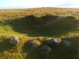

<< Our Photo Pages >> Reenmeen West standing stone and radial stone cairn - Standing Stone (Menhir) in Ireland (Republic of) in Co. Cork
Submitted by frogcottage42 on Monday, 01 March 2010 Page Views: 3829
Neolithic and Bronze AgeSite Name: Reenmeen West standing stone and radial stone cairn Alternative Name: Currakeal Standing StoneCountry: Ireland (Republic of) County: Co. Cork Type: Standing Stone (Menhir)
Nearest Town: Glengariff
Latitude: 51.761292N Longitude: 9.54434W
Condition:
| 5 | Perfect |
| 4 | Almost Perfect |
| 3 | Reasonable but with some damage |
| 2 | Ruined but still recognisable as an ancient site |
| 1 | Pretty much destroyed, possibly visible as crop marks |
| 0 | No data. |
| -1 | Completely destroyed |
| 5 | Superb |
| 4 | Good |
| 3 | Ordinary |
| 2 | Not Good |
| 1 | Awful |
| 0 | No data. |
| 5 | Can be driven to, probably with disabled access |
| 4 | Short walk on a footpath |
| 3 | Requiring a bit more of a walk |
| 2 | A long walk |
| 1 | In the middle of nowhere, a nightmare to find |
| 0 | No data. |
| 5 | co-ordinates taken by GPS or official recorded co-ordinates |
| 4 | co-ordinates scaled from a detailed map |
| 3 | co-ordinates scaled from a bad map |
| 2 | co-ordinates of the nearest village |
| 1 | co-ordinates of the nearest town |
| 0 | no data |
Internal Links:
External Links:
I have visited· I would like to visit
frogcottage42 has visited here
")
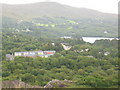
A striking stone in a prominent position overlooking Glengriff harbour.
There are several smaller stones positioned around which are marked on the OS as cairns.
If you stand with your back to the stone you will see the position of the related stone circle about 1Km to the North.
Gaelic Laird comments:
There are two sites in this location:
A solitary standing stone, recorded as site CO090-008001-
Near end of boggy plateau on S side of Barraboy Mountain. Stone (H 2m; 1.5mx 0.7m); long axis NE-SW. (Ó Nualláin 1984b, 77, no. 16).
And three metres to the south of the standing stone is a radial-stone cairn, recorded as site CO090-008002-
Six radially-set stones (H 0.2m - 0.6m) indicate ring c. 7m in diameter. Stone (H 0.9m; 1.2m x 0.4m) stands within ring at N. Precise nature of this structure is unclear but more likely to be cairn than enclosure.
The above description is derived from the published 'Archaeological Inventory of County Cork. Volume 1: West Cork' (Dublin: Stationery Office, 1992).
You may be viewing yesterday's version of this page. To see the most up to date information please register for a free account.
")
")
Do not use the above information on other web sites or publications without permission of the contributor.
Nearby Images from Geograph Britain and Ireland:
©2009(licence)
©2020(licence)
©2017(licence)
©2006(licence)
©2015(licence)
The above images may not be of the site on this page, they are loaded from Geograph.
Please Submit an Image of this site or go out and take one for us!
Click here to see more info for this site
Nearby sites
Click here to view sites on an interactive map of the areaKey: Red: member's photo, Blue: 3rd party photo, Yellow: other image, Green: no photo - please go there and take one, Grey: site destroyed
Download sites to:
KML (Google Earth)
GPX (GPS waypoints)
CSV (Garmin/Navman)
CSV (Excel)
To unlock full downloads you need to sign up as a Contributory Member. Otherwise downloads are limited to 50 sites.
Turn off the page maps and other distractions
Nearby sites listing. In the following links * = Image available
94m NNW 346° Kilcaskan rock art* Rock Art
541m NNE 17° Currakeal Stone Row* Stone Row / Alignment
584m NNE 18° Currakeal boulder burial* Burial Chamber or Dolmen
597m N 9° Canrooska Stone Row* Stone Row / Alignment
611m N 10° Canrooska Stone Circle* Stone Circle
792m N 4° Ceann Rúscach standing stone* Standing Stone (Menhir)
2.4km NNW 338° Crossferry east* Standing Stone (Menhir) (V9257459890)
2.6km N 2° Barraboy mountain* Wedge Tomb (V9357160171)
2.7km N 359° Canrooska standing stone* Standing Stone (Menhir)
2.9km NE 50° Cuanán standing stone* Standing Stone (Menhir)
3.1km NE 48° Coonane wedge tomb* Wedge Tomb
3.4km NW 323° Tooreen bronze age copper mine* Ancient Mine, Quarry or other Industry
4.0km NNE 13° Esk East standing stone* Standing Stone (Menhir)
4.1km NNE 18° An Eisc Thoir wedge tomb* Wedge Tomb
5.2km ENE 71° Cooleenlemane rock scribing* Cave or Rock Shelter
5.6km E 100° Mill Little* Stone Circle (V989565)
5.6km E 100° Mill Little Stone Row / Alignment (V98985653)
7.1km NE 38° Coorleagh ring fort* Stone Fort or Dun
7.2km NNE 25° Feaghna* Rock Art (V966641)
7.6km ESE 114° Dromkeal* Stone Circle (W00315445)
7.9km SW 226° Kealagowlane Stone circle* Stone Circle (V876523)
8.1km N 1° Derrynacoulagh* Rock Art (V9371865698)
8.1km NNE 16° Dromagorteen* Stone Circle (V9586165343)
8.5km N 355° Derrynacaheragh Wedge Tomb (V9288166088)
8.6km SW 227° Kealagowlane Standing stone* Standing Stones (V86975196)
View more nearby sites and additional images


 We would like to know more about this location. Please feel free to add a brief description and any relevant information in your own language.
 Wir möchten mehr über diese Stätte erfahren. Bitte zögern Sie nicht, eine kurze Beschreibung und relevante Informationen in Deutsch hinzuzufügen.
 Nous aimerions en savoir encore un peu sur les lieux. S'il vous plaît n'hesitez pas à ajouter une courte description et tous les renseignements pertinents dans votre propre langue.
 Quisieramos informarnos un poco más de las lugares. No dude en añadir una breve descripción y otros datos relevantes en su propio idioma.