Featured: How and why the ancients enchanted Great Britain and Brittany

How and why the ancients enchanted Great Britain and Brittany

Random Image


The Altar

Secrets of the Avebury Stones

Secrets of the Avebury Stones

Who's Online

There are currently, 270 guests and 1 members online.

You are a guest. To join in, please register for free by clicking here

Sponsors

<< Our Photo Pages >> Dromagorteen - Stone Circle in Ireland (Republic of) in Co. Kerry

Submitted by Tom_Bullock on Tuesday, 25 July 2006  Page Views: 24305

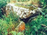
Neolithic and Bronze AgeSite Name: Dromagorteen Alternative Name: Bonane Heritage Park
Country: Ireland (Republic of) County: Co. Kerry Type: Stone Circle
Nearest Town: Kenmare  Nearest Village: Dromagorteen
Map Ref: V9586165343
Discovery Map Number: D85
Latitude: 51.831174N  Longitude: 9.511374W
Condition:
5Perfect
4Almost Perfect
3Reasonable but with some damage
2Ruined but still recognisable as an ancient site
1Pretty much destroyed, possibly visible as crop marks
0No data.
-1Completely destroyed
4 Ambience:
5Superb
4Good
3Ordinary
2Not Good
1Awful
0No data.
4 Access:
5Can be driven to, probably with disabled access
4Short walk on a footpath
3Requiring a bit more of a walk
2A long walk
1In the middle of nowhere, a nightmare to find
0No data.
3 Accuracy:
5co-ordinates taken by GPS or official recorded co-ordinates
4co-ordinates scaled from a detailed map
3co-ordinates scaled from a bad map
2co-ordinates of the nearest village
1co-ordinates of the nearest town
0no data
5

Internal Links:
External Links:

I have visited· I would like to visit

rrmoser would like to visit

Jansold visited on 8th Sep 2014 - their rating: Cond: 5 Amb: 4 Access: 3

Kith visited on 1st Mar 2010 - their rating: Cond: 4 Amb: 4 Access: 4

justme frogcottage42 have visited here

Average ratings for this site from all visit loggers: Condition: 4.5 Ambience: 4 Access: 3.5

Dromagorteen
Dromagorteen submitted by frogcottage42 : Complete with helpful information boards and sizeable boulder burial in the centre. A fulacht fiadh stand 12m to the NE and a well preserved rath (ring fort) about 200m to the West (Vote or comment on this photo)
Axial stone circle in Kerry. The stone circle is situated in the townland of Dromagorteen and is one of the finest examples in the Cork/Kerry region. One of its most striking features is its vantage point overlooking the valley. It is known locally as the “Judge and Jury” as it consists of thirteen stones with a central bolder burial.

It is the centrepiece of a complex astronomical calendar, which includes both solar and lunar cycles. Monuments on the horizon mark the rising and setting of the moon on significant dates. An imaginary axis drawn from these points to the stone circle reveals the astonishing fact that many of the monuments in the valley are on or close to these radial lines.

Circle diameter: 33 feet

Note: Bonane Heritage Park opens, see comment
You may be viewing yesterday's version of this page. To see the most up to date information please register for a free account.


Dromagorteen
Dromagorteen submitted by frogcottage42 : Another sign showing how this circle fits into it's landscape. (Vote or comment on this photo)

Dromagorteen
Dromagorteen submitted by frogcottage42 : This is on a signpost next to the circle. apologies for infringement of copyright but this is a exceptionally accessible circle ad advertising it wont hurt. (Vote or comment on this photo)

Dromagorteen
Dromagorteen submitted by justme : Fulachta Fhia (Vote or comment on this photo)

Dromagorteen
Dromagorteen submitted by justme : Bullaun (Vote or comment on this photo)

Dromagorteen
Dromagorteen submitted by justme : Sfanding Stone

Do not use the above information on other web sites or publications without permission of the contributor.
Click here to see more info for this site

Nearby sites

Click here to view sites on an interactive map of the area

Key: Red: member's photo, Blue: 3rd party photo, Yellow: other image, Green: no photo - please go there and take one, Grey: site destroyed

Download sites to:
KML (Google Earth)
GPX (GPS waypoints)
CSV (Garmin/Navman)
CSV (Excel)

To unlock full downloads you need to sign up as a Contributory Member. Otherwise downloads are limited to 50 sites.


Turn off the page maps and other distractions

Nearby sites listing. In the following links * = Image available
 1.4km SSE 148° Feaghna* Rock Art (V966641)
 2.2km W 278° Derrynacoulagh* Rock Art (V9371865698)
 3.1km WNW 283° Derrynacaheragh Wedge Tomb (V9288166088)
 3.1km SE 135° Coorleagh ring fort* Stone Fort or Dun
 3.4km N 358° Lackaroe* Stone Circle (V95826876)
 4.0km SSW 195° An Eisc Thoir wedge tomb* Wedge Tomb
 4.1km SSW 199° Esk East standing stone* Standing Stone (Menhir)
 4.3km N 3° Doughill* Stone Circle (V962696)
 4.5km NE 56° Gullaba enclosure and boulder-burial* Ancient Village or Settlement
 5.6km SSW 204° Canrooska standing stone* Standing Stone (Menhir)
 5.6km NE 46° Gulba standing stone, hut site and enclosures* Standing Stone (Menhir)
 5.6km SSW 203° Barraboy mountain* Wedge Tomb (V9357160171)
 5.7km S 179° Coonane wedge tomb* Wedge Tomb
 5.7km N 349° Drom an tSeabhaic standing stone* Standing Stone (Menhir)
 5.8km N 352° Dromatouk row* Stone Row / Alignment (V9520771079)
 5.9km S 180° Cuanán standing stone* Standing Stone (Menhir)
 6.0km N 351° Dromatouk stones* Standing Stones (V9503771325)
 6.1km N 354° Dromatouk circle* Stone Circle (V953714)
 6.2km NE 46° Gurteen Standing Stone* Standing Stone (Menhir) (W00436961)
 6.4km SSW 210° Crossferry east* Standing Stone (Menhir) (V9257459890)
 6.4km NNE 31° Lounaghan standing stones, cairns and enclosures* Ancient Village or Settlement
 6.5km NE 45° Gurteen stone circle* Stone Circle (W00536983)
 6.6km SW 221° Tooreen bronze age copper mine* Ancient Mine, Quarry or other Industry
 6.7km SSE 156° Cooleenlemane rock scribing* Cave or Rock Shelter
 7.1km NNW 330° Killowen* Stone Circle (V924716)
View more nearby sites and additional images

<< Moor Divock Cairn

Forst Suckow Dolmen >>

Please add your thoughts on this site

Clickable Map of Ireland

Avebury Archaeology Map - Worldwide Delivery

Avebury Archaeology Map - Worldwide Delivery

Sponsors

Auto-Translation (Google)

Translate from English into:

"Dromagorteen" | Login/Create an Account | 11 News and Comments
  
Go back to top of page    Comments are owned by the poster. We aren't responsible for their content.
Re: Dromagorteen by Andy B on Monday, 07 May 2018
(User Info | Send a Message)
National Monuments Service:
Class Stone circle - multiple-stone
Townland DROMAGORTEEN
SMR No. KE102-032002-
Description In Bonane Heritage Park, on a break on a SW-facing slope. A circle (diam. 10m) of probably thirteen stones, six of which are upright. The stones measure L 0.75-1.55m; T 0.4-0.8m and H 0.8-1.4m. One of the entrance stones at the NNE, a quartz-veined boulder, has fallen. The other entrance stone (1m x 0.8m; H 1.4m) is the tallest stone. The flat-topped axial stone (1.6m x 0.8m; H 0.8m) stands at SSW. A boulder-burial (KE102-032003-) occupies the centre of the interior. A fulacht fia (KE102-032004-) lies c. 25m to the E. The above description is derived from the published 'Archaeological Inventory of County Kerry. Volume I: South-West Kerry' (Dublin: Stationery Office, 2009). In certain instances the entries have been revised and updated in the light of recent research. Date of upload: 30 May 2011

[ Reply to This ]

Re: Dromagorteen by justme on Monday, 29 July 2013
(User Info | Send a Message)
The Bonane Heritage Park is well worth a visit with friendly helpful staff, good footpaths, seats, short grass and stunning

views. It includes the following ancient monuments: A ring-fort, a stone circle which contain a boulder burial, a standing

stone, rectangular hut remains, a ruined cottage (pre-famine), a burnt mound (fulachta fhia) and an object described as a

bullaun stone. All these are in an area a few hundred metres across. Most are mentioned in the Co. Kerry archaeological

survey, as quoted below from archaeology.ie.

The Ring-Fort

'In Bonane Heritage Park, on a steep SW-facing slope, in the valley of the Sheen River. A circular area (37m E-W; 34m N-S)

defined by two earthen banks with an intervening fosse. The inner bank (Wth 8.3m; int. H 2.7m; ext. H 2.8m) is faced

externally with large stones E-ESE. The intervening fosse (Wth 2.2m) is cut (H 2.5m) into the upslope SW-SE. An outer bank

(Wth 3.8m; H 1.3m) is visible SE-SW. There is a causeway entrance (Wth 4m) at SE and a break (Wth 3m) in the inner bank at S.

The S portion of the interior is raised and the N portion is cut into the upslope to compensate for the hillslope. However, the

interior retains a gentle slope down to the SW.'

The Stone Circle

'In Bonane Heritage Park, on a break on a SW-facing slope. A circle (diam. 10m) of probably thirteen stones, six of which are

upright. The stones measure L 0.75-1.55m; T 0.4-0.8m and H 0.8-1.4m. One of the entrance stones at the NNE, a quartz-

veined boulder, has fallen. The other entrance stone (1m x 0.8m; H 1.4m) is the tallest stone. The flat-topped axial stone

(1.6m x 0.8m; H 0.8m) stands at SSW. A boulder-burial (KE102-032003-) occupies the centre of the interior.'

The Boulder Burial

'In Bonane Heritage Park, on a break on a SW-facing slope. The boulder-burial stands in the centre of a multiple-stone circle

(KE102-032002-) and consists of a large boulder (1.6m x 1.6m; T 1m) resting on at least three support-stones. A pad-stone

has been inserted to steady the boulder.'

The Hut Site

'In Bonane Heritage Park, on a SW-facing slope, in the valley of the Sheen River. The remains of a rectangular hut site (4.9m

N-S; 2.7m E-W) defined by a collapsed drystone wall (T 0.8m; H 1m) which is obscured by ferns and trees.'

Ruined Cottage
This appears to be an unrecorded site, indeed it probably outside the scope of the register as pre-famine ruins are a very

common feature in Ireland.

Fulachta Fhia

'In Bonane Heritage Park, on an undulating SW-facing slope, in the valley of the Sheen River. A horseshoe-shaped grass-

covered mound (10.6m NE-SW; 8.5m NW-SE; H 1.3m) of burnt material with an opening (2.8m NW-SE; 2.6m NE-SW) facing a

wet area to the NW. The mound material is exposed around the roots of a fallen tree.'

The Bullaun Stone

This item is not recorded on archaeology.ie and in my humble opinion is not a bullaun stone. It is a large rock standing at about 60 degrees to its bedding plane. An almost vertical area appears to be a glacier scored face. The larger hollows in it look to me as though they are water worn "pot-holes" although the small ones could have been drilled. My impression of it is a grotesque face similar to those common at Avebury and Carnac.

Final Note

The entrance to the park is at 51.828882; -9.520340, I hope to visit again shortly to get the geolocations of all the monuments.
[ Reply to This ]

Re: Dromagorteen by Anonymous on Thursday, 06 January 2011
I love this site, it's not over crowded and it has great photo opportunities. Yes the incline is steep but when we went, there was someone on site to open the gate and let us drive up. The area is well maintained and the information boards are simple and succinct. It does the heart good to see what a community can do when it pulls together; I live in a big city in England and trust me this would never happen. The 4 euro entrance fee was well worth it and all in all we spent about an hour and a half there. Even if you're not into stone circles and the like, there is something special about the atmosphere so make a point of going.
[ Reply to This ]

Re: Dromagorteen by bburdetteva on Saturday, 17 July 2010
(User Info | Send a Message)
This is part of a heritage park which includes a ring fort and the Bullaun Stone. It is well maintained by the community. There is a small entry fee but worth the support that they receive. It is a long walk up medium steep incline but it is over a well maintained gravel pathway. I even saw a 'tour' van that had driven up, so disabled access should be possible. No toilets up top but portable unit at entrance (so, prepare!).
[ Reply to This ]

Re: Dromagorteen by bburdetteva on Saturday, 17 July 2010
(User Info | Send a Message)
Condition: 4
Ambience: 4
Access: 3
[ Reply to This ]

Re: Dromagorteen by frogcottage42 on Wednesday, 17 March 2010
(User Info | Send a Message)
Condition:3
Ambience:4
Access:4
Accuracy:V 95819,65317

Entry to the park is 4 euro by honesty box.
This park is a good introduction to prehistoric sites but is full of things which will really irritate the more knowledgeable.
For the more intrepid the excellent circles at Lackaroe, Gurteen, Kenmare or Dromatouk are within a ten minute drive of this spot.
[ Reply to This ]

Speech by John O'Donoghue, T.D. Minister for Arts, Sport and Tourism, at the opening by Andy B on Tuesday, 25 July 2006
(User Info | Send a Message)
Ladies and Gentlemen:

It is a great pleasure to be here in Kenmare today for the opening Bonane Heritage Park. This impressive project, which was undertaken by the Bonane Community Co-operative Society is an excellent example of a local community working with the relevant public bodies to protect, preserve and open up the unique archaeological heritage of their area.

The area encompassed by Dromgorteen Forest was long known to contain several monuments of archaeological importance. These ranged from a stone circle of the Bronze Age period to a ringfort or "lios" belonging to the Early Christian period.

I am delighted to note that every effort was made by Coillte to minimise the damage to these monuments during tree-felling operations in 2003. Following the clearance of the trees, a new survey of the area was undertaken on behalf of the Bonane community group.

The survey identified several new monuments in the area including a "bullaun" stone with possible Bronze Age rock art, a Bronze Age cooking site or "fulacht fiadh", as well as two possible burial mounds and two possible "souterrains" or underground passages.

On the advice of the then "Dúchas" Heritage Service as it was at that time, and with the co-operation of Coillte, an archaeologist, Dr. Niall Gregory, was taken on by the community group to oversee the repair and construction of pathways, the resurfacing of a carpark area and the erection of fencing and information signs.

These works were carried out with minimum ground disturbance, thus protecting the archaeological deposits, and in a manner that was not visually obtrusive. The result is a stunning archaeological landscape which has been made accessible to the public in a meaningful way and which hopefully, in the long term will raise awareness of the importance of our rich and exciting archaeological heritage.

I want to sincerely thank and compliment the Bonane Community Co-operative Society and all of those involved in the development of Bonane Heritage Park who gave their time and personal commitment to see this project through to fruition. I have no doubt that it will prove to be a marvellous facility for the people of Bunane and the Kenmare area and indeed the many who will visit from further afield.

Source: http://www.arts-sport-tourism.gov.ie/publications/release.asp?ID=1462
[ Reply to This ]

Re: Dromagorteen by Andy B on Tuesday, 25 July 2006
(User Info | Send a Message)
The park provides the visitor with a 3km circular walk on gravel paths. It offers a vibrant and living link to the first settlers who colonised the Irish countryside. The park hosts a wealth of multi period archaeological monuments including a stone circle, ring fort, standing stone etc even for those with little interest in history and heritage. The visual experience is stunning.

Admission Prices €2
Opening Times Daily: daylight hours
Address Bonane
Kenmare
Co. Kerry
Telephone +353 (0)64 41455
Telephone +353 (0)64 40714
E-mail bonanecommunity@eircom.net
Web http://www.bonane.com

Source:
http://www.corkkerry.ie/individual_results.asp?sID=61875
[ Reply to This ]

Bonane Heritage Park by Andy B on Tuesday, 25 July 2006
(User Info | Send a Message)
Bonane Heritage Park
http://www.bonane.com/archaeology.htm

The official opening of the Bonane Heritage Park took place this on Sunday June 11th, a significant day for the parish of Bonane which includes Glengarriff. It saw the culmination of five years of voluntary work by the people of the parish. Committee members will be pleased to take guests on guided tours and explain how June 11th marks a significant...

More at
http://www.unison.ie/southern_star/stories.php3?ca=41&si=1629565&issue_id=14183
(free registration required)
[ Reply to This ]

Re: Dromagorteen by Anonymous on Tuesday, 25 July 2006
Just back from there, and other sites. This one impressed me because its now part of the Bonane Heritage Park and provides access and the best introductory info for anyone who's never looked into megalithic structures before. Reading the guest book you will find several "nerd" megalith hunters are horrified by the park.

What makes this wonderful is the explanation and the easy visibility of alignments on the mountains around, and all of this is clearly shown on surrounding info boards. Any visitor here gets a wonderful simple crash course in ancient megaliths, geomancy, ley lines etc. much more than any place I know. This has far more to offer than New Grange, for example.

Nearby is one of the best ring fort examples I know in Ireland, a wonderful re-creation of a Fulacht Fiadh on its original site with a wonderful explanation of its own alignments. There's also a unique ballaun stone nearby. I'm not sure abount the standing stone presentation, though.

Even so, all of this including visibility of nearby mountain cairns provides the best insight into Irish megalithiology I know. Its not messed up with ropes, gravel courts etc. The park is very sensitive to what it is sharing. No litter either. A perfect place to introduce children to these wonders, and dogs love visiting too. No farms or farm animals to disturb. Quite a climb, beautiful views, but quite safe.

John Willmott Celtic Ways
[ Reply to This ]
    Re: Dromagorteen by Andy B on Tuesday, 25 July 2006
    (User Info | Send a Message)
    Thanks for the news on this John, Bonane Heritage Park is one we missed. Any chance of some photos?
    Cheers
    [ Reply to This ]

Your Name: Anonymous [ Register Now ]
Subject:


Add your comment or contribution to this page. Spam or offensive posts are deleted immediately, don't even bother

<<< What is five plus one as a number? (Please type the answer to this question in the little box on the left)
You can also embed videos and other things. For Youtube please copy and paste the 'embed code'.
For Google Street View please include Street View in the text.
Create a web link like this: <a href="https://www.megalithic.co.uk">This is a link</a>  

Allowed HTML is:
<p> <b> <i> <a> <img> <em> <br> <strong> <blockquote> <tt> <li> <ol> <ul> <object> <param> <embed> <iframe>

We would like to know more about this location. Please feel free to add a brief description and any relevant information in your own language.
Wir möchten mehr über diese Stätte erfahren. Bitte zögern Sie nicht, eine kurze Beschreibung und relevante Informationen in Deutsch hinzuzufügen.
Nous aimerions en savoir encore un peu sur les lieux. S'il vous plaît n'hesitez pas à ajouter une courte description et tous les renseignements pertinents dans votre propre langue.
Quisieramos informarnos un poco más de las lugares. No dude en añadir una breve descripción y otros datos relevantes en su propio idioma.