

<< Our Photo Pages >> Kjørkjehauen - Standing Stone (Menhir) in Norway in Rogaland
Submitted by kenntha88 on Sunday, 27 September 2020 Page Views: 347
Iron Age and Later PrehistorySite Name: KjørkjehauenCountry: Norway
NOTE: This site is 13.93 km away from the location you searched for.
Fylke: Rogaland Type: Standing Stone (Menhir)
Nearest Town: Stavanger Nearest Village: Vikevåg
Latitude: 59.106302N Longitude: 5.841414E
Condition:
| 5 | Perfect |
| 4 | Almost Perfect |
| 3 | Reasonable but with some damage |
| 2 | Ruined but still recognisable as an ancient site |
| 1 | Pretty much destroyed, possibly visible as crop marks |
| 0 | No data. |
| -1 | Completely destroyed |
| 5 | Superb |
| 4 | Good |
| 3 | Ordinary |
| 2 | Not Good |
| 1 | Awful |
| 0 | No data. |
| 5 | Can be driven to, probably with disabled access |
| 4 | Short walk on a footpath |
| 3 | Requiring a bit more of a walk |
| 2 | A long walk |
| 1 | In the middle of nowhere, a nightmare to find |
| 0 | No data. |
| 5 | co-ordinates taken by GPS or official recorded co-ordinates |
| 4 | co-ordinates scaled from a detailed map |
| 3 | co-ordinates scaled from a bad map |
| 2 | co-ordinates of the nearest village |
| 1 | co-ordinates of the nearest town |
| 0 | no data |
Internal Links:
External Links:
")
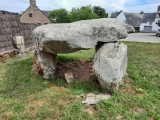
The standing stone is 3,5 metres in height and 50cm wide and around 30cm thick. It is tilting slightly to one side, it appears to have a diagonally "cut off" top. The round barrow is around 20 metres to the south east of the stone, just outside the stone fence surrounding the church yard. It is around 15 metres in diameter and around 2 metres in height. it is covered only in grass and its easy to see. Its supposed to be another smaller round barrow but this could not be located.
From the location on the hill there is a beautiful view over the sea and the surrounding islands!
You may be viewing yesterday's version of this page. To see the most up to date information please register for a free account.
")
")
")
")
")
Do not use the above information on other web sites or publications without permission of the contributor.
Click here to see more info for this site
Nearby sites
Click here to view sites on an interactive map of the areaKey: Red: member's photo, Blue: 3rd party photo, Yellow: other image, Green: no photo - please go there and take one, Grey: site destroyed
Download sites to:
KML (Google Earth)
GPX (GPS waypoints)
CSV (Garmin/Navman)
CSV (Excel)
To unlock full downloads you need to sign up as a Contributory Member. Otherwise downloads are limited to 50 sites.
Turn off the page maps and other distractions
Nearby sites listing. In the following links * = Image available
6.5km E 90° Kjølevik Runestone* Carving
6.9km SE 137° Tau-Åna stone age settlement* Ancient Village or Settlement
7.6km SE 137° Løbrekk av Strand settlement* Ancient Village or Settlement
8.0km SE 141° Strand Barrow Mounds* Round Barrow(s)
8.1km W 264° Vikevåg* Barrow Cemetery
8.2km SE 143° Solbakk* Rock Art
8.5km SSW 214° Pigghedlene* Standing Stones
9.1km SSW 213° Austre Åmøy* Rock Art
9.4km SW 214° Meling Austre Åmøy* Rock Art
9.6km WSW 249° Hedlehaugen* Standing Stones
10.0km WSW 241° Askje Hedlehaug* Standing Stone (Menhir)
10.1km WSW 251° Vaula Settlement* Ancient Village or Settlement
10.9km WSW 257° Mosterøyvegen Standing Stone* Standing Stone (Menhir)
11.3km SW 228° Varaberg* Standing Stone (Menhir)
11.3km SW 229° Hegrebergveien Pigghedlane* Standing Stones
11.3km SW 230° Hegreberg* Standing Stone (Menhir)
11.5km WNW 282° Sørbø Runestone* Carving
11.5km W 281° Austhaugstyttå* Standing Stone (Menhir)
11.6km SE 142° Nag standing stone* Standing Stone (Menhir)
11.7km SE 143° Nagavika* Standing Stone (Menhir)
12.1km WSW 253° Hodnafjell* Standing Stone (Menhir)
12.2km WSW 240° Sokn Standing Stone* Standing Stone (Menhir)
13.3km W 280° Voll Standing Stone* Standing Stone (Menhir)
13.4km W 270° Bakkahodnet* Barrow Cemetery
13.7km SSW 209° Stavangerfjords Vei* Standing Stone (Menhir)
View more nearby sites and additional images


 We would like to know more about this location. Please feel free to add a brief description and any relevant information in your own language.
 Wir möchten mehr über diese Stätte erfahren. Bitte zögern Sie nicht, eine kurze Beschreibung und relevante Informationen in Deutsch hinzuzufügen.
 Nous aimerions en savoir encore un peu sur les lieux. S'il vous plaît n'hesitez pas à ajouter une courte description et tous les renseignements pertinents dans votre propre langue.
 Quisieramos informarnos un poco más de las lugares. No dude en añadir una breve descripción y otros datos relevantes en su propio idioma.