

County Guides No. 15 - West Yorkshire
Submitted by DavidRaven on Friday, 27 February 2004 Page Views: 8737
EnglandCountry: England County: Yorkshire (West)Internal Links:

During the ice-ages the U-shaped valleys were ground from the gritstone. As the glaciers retreated they graced these valleys with more fertile alluvia and gravel, sweetening the soil for cultivation. The lower land was gradually drained and divided by dry-stone walls and hedgerows. The uplands eventually became the acidic windswept moors we know and love today. Evidence of man’s activities in these hills has been discovered from as far back as 7000bce, the settlement at Backstone Beck being a good example.
During the Late Neolithic/Early Bronze Age period the climate, although beginning to deteriorate, was more hospitable in comparison to modern times. The bleak moorland was more fertile, with a degree of shelter from the elements, and so we find traces of habitation in the hills. The common use of the words ‘shaw’ and ‘carr’ for place-names indicate that woodland was much more widespread at that time in upland areas.
The valley of the River Aire runs across the region from east to west. As it passes south of Skipton it allows the crossing of the Pennine hills at the lowest point in northern England; a fact that must have had a bearing on the movement of people and ideas in prehistory. Cowling (1946) also proposed that the adjacent Wharfe valley was part of a major route for trade across the country, from the West coast and the Lake District to the North Sea coastline and the North York Moors. The amount of traffic that flowed through the valleys and over the hills was incredible.
The area was also very important to the Celtic tribes. Dr Anne Ross reckoned that the West Riding (West Yorkshire) was the ‘nucleus of the Brigantian Kingdom’.
The West Yorkshire Archaeology Service have catalogued almost 700 Cup-and-ring marked rocks so far, and there are doubtless many others waiting to be discovered. Almost half are found on or nearby Rombald’s Moor between Ilkley and Leeds/Bradford, which is home to the highest concentration and most varied collection of all the carved stones in Yorkshire.
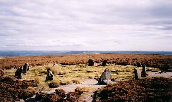
There are numerous stone circles scattered across the county, all of them relatively small and mainly constructed during the Bronze Age. The most well-known of these is probably the Twelve Apostles stone circle on Rombald’s Moor. Other megalithic remains occurring throughout the county include burial mounds, standing stones (like the huge menhir at Todmordon), stone rows, hut circles, settlements (e.g. Woofa Bank) and the enchanting rock-art (the Swastika Stone is a well-known example).
Even the urban areas still turn up a few surprises with flint axes and arrowheads discovered in gardens and parks. Old maps show named standing stones in the cities (e.g. the Witches Stone in Meanwood, Leeds and the Pin Stone in Manningham, Bradford), and circles and prehistoric rock carvings are hidden away in pockets of suburban woodland.
Forgotten sites are frequently ‘re-discovered’ by the megalithic enthusiasts, and it is likely there are many more to be unearthed in the future…
(For simplicity, the metropolitan boroughs of Bradford, Calderdale, Kirklees, Leeds and Wakefield are included under the county of West Yorkshire)
Note: Could you be our site guide for your county? Sign up in the Forum. We're also looking for volunteer experts for specific types of site.


 We would like to know more about this location. Please feel free to add a brief description and any relevant information in your own language.
 Wir möchten mehr über diese Stätte erfahren. Bitte zögern Sie nicht, eine kurze Beschreibung und relevante Informationen in Deutsch hinzuzufügen.
 Nous aimerions en savoir encore un peu sur les lieux. S'il vous plaît n'hesitez pas à ajouter une courte description et tous les renseignements pertinents dans votre propre langue.
 Quisieramos informarnos un poco más de las lugares. No dude en añadir una breve descripción y otros datos relevantes en su propio idioma.