


County Guides: Introduction to Shropshire
Submitted by TimPrevett on Sunday, 29 May 2005 Page Views: 16516
EnglandCountry: England County: ShropshireInternal Links:

It often can be seen that the geology and natural history are influential in the choice of settlement, though early sites are not that numerous. Geologically, Shropshire boasts the oldest rocks in the country: precambrian sandstones formed 667,000,000 to 545,000,00 years ago. The Long Mynd, The Wrekin (pronounced 'ree-kin'), and Caer Caradoc (Church Stretton) all sit upon this most ancient of rock groups.
Among the earliest known human sites are the Roveries Hillfort in the south west, where Neolithic activity has been noted, and Grinshill, a relatively small but prominent hill north of Shrewsbury, that has been the focus of Mesolithic and Neolithic discoveries.
Shropshire is centrally placed with the Welsh Borders to west (also known as the Welsh Marches), and the English Midlands to the east. The River Severn provides an important link to the Bristol Channel and Atlantic Ocean; it also gives a dramatic example of how the forces of nature dictate human activity. Before the last Ice Age, the river originally flowed north to the River Dee. This outflow became blocked, causing a vast lake to form - Lake Lapworth. Eventually this overflowed to the south east, gouging out the Ironbridge Gorge, and redirecting the river - the current course of The River Severn.
Other areas of the county were also shaped by the Ice Age. The only part of Shropshire to have been above the ice sheet, were the rocks of The Stiperstones ridge. Frozen, thawed, and re-frozen, the shattered other-worldly landscape of The Stiperstones became home to many bronze age cairns. The already ancient and prominent skyline was being used by humans.
The departure of the ice sheet further shaped the landscape canvas upon which humans would draw their story. The meltwaters above what is now The Long Mynd carved out deep hollows (called 'batches'). The remaining upland plateau would later host farming communities. Their earthworks and 'border controls' survive in the form of cross-ridge dykes (such as Barrister’s Plain, Devil’s Mouth, and High Park), burial monuments, as well as the prehistoric trade route of The Portway, which (along with the River Severn) would have helped carry the neolithic axe trade from the site of Cwm Mawr near Corndon Hill. Other farming communities left evidence on Stapeley Hill, and Stitt Hill to the west of The Long Mynd.
In the north of the county, The Shropshire Meres formed from vast pieces of ice. These were covered by debris, and melted after the main ice sheet retreated, resulting in enormous depressions in the ground filling with water. This area around Ellesmere is sometimes called "Shropshire's Lake District". The Berth, an Iron Age settlement utilised such a glacial lake and mound for its defences, and Old Oswestry Hillfort, another low lying site was built upon a glacial mound, thus aiding its situation.
There are a few Megalithic Monuments per se in the county. Two definite stone circles: Mitchell's Fold (allegedly the site of Arthur drawing the Sword from the Stone), and the nearby Hoarstones are well known. Unusually, both have central stones. There were an additional eight possible stone circles - either completely destroyed, misinterpreted cairns, fortuitous natural features, or mining upcast. These were Shelve, Pennerley, Titterstone Clee (at least three claimed circles), Robin Hood's Chair, Pen y Wern and The Grey Stones.
Concerning Standing Stones, many of these are (or were) situated closer to the Welsh Borders. Good examples such as Carreg y Big and Cynynion survive west of Oswestry. Closer to the town a number of megaliths have perished. The south west around Clun has many reports of stones, including what was Shropshire's largest menhir at Whitcott Keysett. Sadly, this is now pulled down and broken. Some, such as The Fairy Stone (noted in Paul Devereux's "Places of Power"), and Clun Hill are natural glacial erratics. It is likely nearly all the others have gone.
Other Bronze Age sites worthy of a visit include the Barrow Cemetery at Bromfield, once home to twenty barrows, and three flat cremation cemeteries; notable finds are now in Birmingham Museum. A possible stone row was discovered on the Stiperstones during 1993-94, though has yet to be visited in person. Ring Cairns are another rare monument type in Shropshire, but two examples can be found at Botley Stone on The Long Mynd, and Selattyn Hill west of Oswestry.
Dolmens are near unknown. Robin Hood's Chair near Baschurch, and The Giant's Grave between Mitchell's Fold and The Hoarstones are two known unlikely candidates. The former is destroyed (as noted possibly a stone circle, or just quarry upcast), the latter probably a fortunately arranged natural feature.
Henges, a key monument type of the Bronze Age, do not survive in Shropshire. Strefford, just north of Craven Arms, and Chirbury, in the far west make two possible henge sites, but these only show as occasional cropmarks.
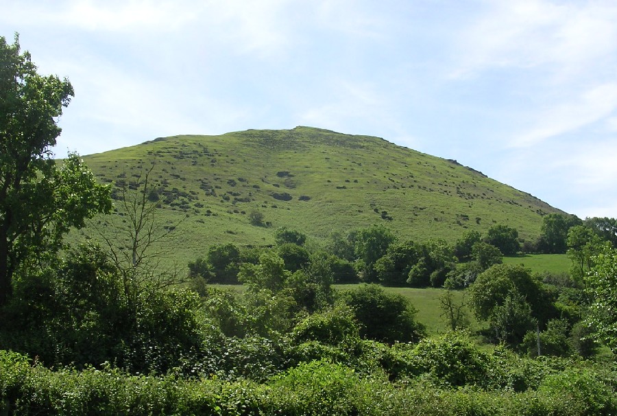
In terms of numerical superiority, it is the county's Iron Age hillforts which come up top (hence the choice of main picture for this article) . There are over fifty defended settlements, from the small (such as Bodbury Ring and Nordy Bank) to the huge (Norton Camp, Old Oswestry, Titterstone Clee). From the towering locations of The Wrekin (which is said to have helped inspire JRR Tolkien with the Lord of the Rings) or either of the Caer Caradocs (two forts by the same name, one near Church Stretton, the other at Chapel Lawn), to the low marsh surrounded earthworks of The Berth, near Baschurch. Some have been damaged, or been quarried out of existence, but for hillforts, Shropshire has an enormous amount to offer.
Prehistory for Shropshire came to a decisive end in AD 47. The ancient power base of the British tribe, the Cornovii, located at The Wrekin, was stormed by the Romans. What we call the Iron Age had passed. Shropshire was left with a prehistoric heritage to be either re-used, developed, ignored, quarried, or enjoyed for millennia thereafter.
To further augment enjoyment and interpretation of this wonderful history and heritage, there are a number of excellent and usable resources to recommend.
There are currently two guidebooks which cover some of the best prehistoric sites, but also including later archaeology. Shropshire an Archaeological Guide, by Michael Watson (ISBN 0903802805) has 27 out of 83 locations covering Bronze and Iron Age sites. Shropshire from the Air: Man and the Landscape by Michael Watson & Chris Musson (ISBN 0903802570) covers just over 20 prehistoric locations with superb insights and aerial photography.
On the web, Secret Shropshire is most recommended. An extensive online searchable archive with images and information aids any hint of a passion for learning more about the county. Similarly, Shropshire Roots is looking promising. If following a link off The Megalithic Portal, please remember to return!
The BBC Shropshire pages are also worth a visit. Online galleries and panoramic photographs bring further illumination to the history and heritage.
For general websites, Virtual Shropshire gives comprehensive tourist information links, with accommodation, other places to see etc.
For an excellent overview as well as extensive information about the county’s geology, Shropshire Rocks is unmissable.
Also recommended is Shropshire Hills Area of Outstanding Natural Beauty website, and The Shropshire Hills Shuttles which provide an alternative form of transport to much of the south west of the county during weekends and bank holidays over the spring and summer months.
More information can be learned from the county’s museums . Rowley’s House Museum in Shrewsbury and the Secret Hills Discovery Centre in Craven Arms both have good information and displays on prehistory.
The council’s Archaeology Department organize a programme of summer walks, which sometimes includes prehistory.
The Shropshire Archaeological and Historical Society will help give in depth information, with a published quarterly “Transactions Of” journal. Finally, for the dedicated researcher, getting to grips with the Shropshire Archives , with friendly and helpful staff, is a must.
Copyright Tim Prevett.


 We would like to know more about this location. Please feel free to add a brief description and any relevant information in your own language.
 Wir möchten mehr über diese Stätte erfahren. Bitte zögern Sie nicht, eine kurze Beschreibung und relevante Informationen in Deutsch hinzuzufügen.
 Nous aimerions en savoir encore un peu sur les lieux. S'il vous plaît n'hesitez pas à ajouter une courte description et tous les renseignements pertinents dans votre propre langue.
 Quisieramos informarnos un poco más de las lugares. No dude en añadir una breve descripción y otros datos relevantes en su propio idioma.