


County Guides No.3 - Isles of Scilly
Submitted by Thorgrim on Saturday, 30 October 2004 Page Views: 19980
EnglandCountry: England County: Isles of ScillyInternal Links:

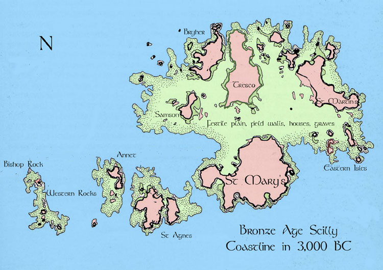
The first farmers of the Neolithic (4000-2500BC) came in small boats from Cornwall to a rapidly changing landscape. After the last Ice Age, rising sea levels flooded low-lying areas and by 3000 BC, the island had become an archipelago. Scilly is visible from the cliffs of Cornwall and so perhaps the first visitors came to see what was there. They stayed a while to hunt and fish before returning home. Then, between 2500 and 700BC, Neolithic people came to stay. They began to clear the woods, erect standing stones and to build their remarkable entrance graves. But the waters kept rising, the fertile central plain was lost and communities were forced to higher and rockier ground. Soon the hilltops and crags were separate islands and islets.
More than five hundred Neolithic and Bronze Age sites above the present high water line have been excavated in the Isles of Scilly. With another thirty or so only accessible at the lowest tides, excavations of these have only been possible for short periods at low water. Normally submerged sites that have been excavated include: ten hut circles, seven cists and graves, four field wall enclosures and twelve other occupational sites and partial exposures in eroding cliffs. How many more are permanently submerged and waiting for underwater archaeologists? There are many field walls and hut circles to be seen at the lowest tide when it is still possible to walk from Samson to Bryher and from Bryher to Tresco. In Roman times, all of the islands were one (variously referred to as Sylina Insula and Siluram Insulam - singular, not plural i.e. The Scilly Island) with the exception of St Agnes and Annet. This has given rise to the legend that Scilly is a remnant of the Lost Land of Lyonesse. Certainly the exciting remains of the Romano-British settlement, shrine and brooch factory on tiny Nornour, were once parts of a much larger community of a lost harbour on the shore of the main island. This island lasted until Tudor times when it was known as Ennor.

 We would like to know more about this location. Please feel free to add a brief description and any relevant information in your own language.
 Wir möchten mehr über diese Stätte erfahren. Bitte zögern Sie nicht, eine kurze Beschreibung und relevante Informationen in Deutsch hinzuzufügen.
 Nous aimerions en savoir encore un peu sur les lieux. S'il vous plaît n'hesitez pas à ajouter une courte description et tous les renseignements pertinents dans votre propre langue.
 Quisieramos informarnos un poco más de las lugares. No dude en añadir una breve descripción y otros datos relevantes en su propio idioma.