


Abandoned Landscapes - The Berwyn - Introduction
Submitted by TimPrevett on Sunday, 03 September 2006 Page Views: 5874
Multi-periodCountry: Wales
The Berwyn
Map 125
Introduction
For 15 miles from north to south no road ventures across the backbone of the Berwyn Hills.
Sometimes single-track roads weave up side valleys, visiting farms and stock shelters, but they give up the challenge as the ground veers upwards onto the great open heather lands and the humped ridge. This watershed helps define the human geography of the area into four more or less distinct topographic areas.
Let us start our tour with the North Berwyn which stretches from Corwen to Llangollen above the Dee valley, a fine empty heather and peat moorland (fig x). Down in the lovely vale are two settlements, Llidiart y Parc and Glyndyfrdwy, each sitting at the mouth of small side-valleys which penetrate south up and into the moorland fastness. These provided access to a number of disused slate quarries and mines now beginning to be reclaimed by nature. On the hill-slopes a string of Bronze Age cairns overlook the fertile main valley, but as you venture deeper into these hills there is little obvious sign of previous settlement and activity [note 1].
The second catchment is the long western block which similarly has two villages spaced along its length at the opening of side-cwms, Cynwyd and Llandrillo. This was one of the 'core settlement areas' of North Wales, with three chambered cairns attesting to Neolithic settlement. Today the relatively wide river plain and the lower valley slopes provides good cattle and sheep pasture and meadow, and the cwms above the villages provide access to extensive upland grazing-grounds; the same must have been true in prehistory.
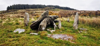
Two of these Neolithic cairns lie on low land near the river; one is beside the modern road between Cynwyd and Llandrillo at Tan-y-Coed and the other lies four kilometres away across the river from Llandrillo in beautiful floodplain meadow at Branas Uchaf adjacent to buzzard-hunted woods on the valley slopes. The setting of these two sites reminds me of a miniature Boyne Valley. A third site, Craig Yr Arian, is hidden in plantation on a high shoulder of ground to the south [note 2].
As has been noted in Part 1, areas with Neolithic monuments tend to have a continuing tradition of settlement and monument building, and here we have the famous (and photogenic) Early Bronze Age kerb circle at Moel ty Uchaf which stands on a hill beside routeways across the main ridge (056371, Burnham 32-3). Across the far side of the valley, just above the edge of the floodplain and intervisible with this monument is the cairn circle at Tyfos (028388, Burnham 31). There are also cairns on the upland fringes and along the main Berwyn ridge, and a couple of later prehistoric settlement sites (e.g. 024376, 047353) [note 3].
Next is a topgraphically complex upland area to the south, fronting onto the Tanat Valley which eventually leads down towards the River Severn and the English Midlands. The small town of Llangynog, overlooked (and preceded) by the dominating presence of the Craig Rhiwarth hillfort, lies at the nodal point where the broad lush river plain narrows and divides into Cwm Rhiwarth and Cwm Pennant (see chapter x). Further east the headwaters of the Afon Rhaeadr rising deep in the hills, are notable for the Bronze Age 'sanctuary' site of Rhos-Y-Beddau beside the Afon Disfygnia (058303).
Finally, the eastern side of the Berwyn covers the largest area; its southern zone has long sheltered valleys rich in good grazing land such as Cwm Maen Gwynedd and Cwm Canol which wend almost to the base of the crags of the main ridge, and extensive high pastures especially around the Tomle spur. In contrast the upland north of the Wayfarers Pass is a remote nomansland of peat and heather where the River Ceiriog gathers its waters from Cerrig Coedig and Ceiriog Ddu, with wretched plantation-stands lower down. This area feels as if it has always been poor, intractable land, bearing the signature of a truly empty landscape - tops and saddles without markers or burial cairns. In terms of atmosphere, it really belongs with the north Berwyn.
For thousands of years the topography of this massif has defined not just territorial boundaries but also circumscribed how people have moved into and across the uplands and between the valleys. These hills present a remarkable, perhaps unparalleled survival of upland paths and passes used for local and long-distance contacts, visits, exchanges or livestock movements. The northern area is linked over its low crest to the eastern hills by two main trackways, one from Llidiart y Parc and the other from Glyndyfrdwy (see below). There are also three east-west routes crossing the main ridge which are likely to have been used for long-distance travel. These enabled communication between the Welsh mountain zone and England via the upper Severn Valley. One from Cynwyd crosses the saddle just south of Moel Fferna (115393) [see chapter X], another via what is now known as the Wayfarers Pass is marked by a large prehistoric cairn, and a third crosses at Bwlch Maen Gwynedd, marked by a standing stone and cairn (076341). The high pass of Milltir Gerrig (020305) lies at a junction of ancient routeways; in addition to linking the Tanat valley to the Llandrillo territory, it connects with a route north west to Bala and beyond [note 4]
Note 1: Firbank provides a good description of the last years of the mines from his visit in 1952 (1971 23-36). Cairns at e.g. 107408, 135414]
Note 2: Tan-y-Coed (047396) is much mutilated but was probably originally circular with a diameter of c.50m. Bowen and Gresham refer to a large capstone with a chamber visible. Branas Uchaf (011375) has also been damaged but was probably originally a circle with a diameter of c.25m and a central megalithic chamber (several stones are visible).
(2 cont.) Craig Yr Arian (012358), a gouged heap of stone with a dislodged capstone and intrusive modern walling is the sorriest-looking prehistoric site I know. Because of the forest cover it is difficult to assess its topographic situation but its builders made no attempt to site it in view of the nearby tomb of Branas Uchaf; rather it seems to lie on a minor saddle between the wartersheds of the Dee and the Afon Dinam (a feeder of the Ceidiog), and if anything it seems to favour the Afon Ceidiog side of the catchment. At c.370m I think it is the highest megalithic site in North Wales, and in terms of its siting is perhaps more reminiscent of a Late Neolithic/Bronze Age cairn. See Bowen and Gresham 1967, 29-32; Burnham 1995, 12-13, 196)
Note 3: I tentatively hypothesise a prehistoric ford or ferry across the Dee at Tyfos, providing an alternative to the traditional crossing at Cynwyd. This would connect both circles to a direct route across the Berwyn massif into the North Wales heartland and perhaps 'explain' their pairing (it should be noted that Bowen and Gresham proposed this very course 35 years before I thought of it (1967, 3-4)).
(3 cont.) The route north would pass Tyfos and then cross the unfrequented minor uplands of Mynydd Mynyllod via the natural breach created by Nant Mynydd Mynyllod. The evidence is circumstantial, consisting only of the pure elegance of the route on the Ordnance Survey map and indications of a pre-modern path alongside the modern bridleway to the east of the stream. This initially rises by some heavily disturbed zig-zags at 028390 (to join a worn track from the east) and is thereafter apparent sporadically (e.g. 027391, 025396). Without a now-lost river crossing here it lacks purpose beyond a local stock way onto the higher ground.
(note 3 cont.) The crux of the route, across boggy and overgrown terrain passes between a small standing stone on a slight eminence (marked as a boundary stone on the map (019407)) to the east, and a dense grouping of cairns on the slope to the west. Most of the latter are undoubtedly clearance cairns (probably prehistoric) but I hazard that two prominent larger ones may be equivalent to pass-markers (017407) (NB. the ancient cairns are distinguishable from their frequent recent counterparts which are characterised by massive boulders). This surprisingly remote and unspoiled watershed zone, which includes the enigmatic Llyn Mynyllod, has the feel of a prehistoric presence lying just beneath the surfaces of the land and water. Writing in connection with the kerb circle and ring cairn a little further north along this hypothetical route, Frances Lynch observes that: '...the area as a whole is important in prehistory for it forms a nodal point to many natural lines of communication.' (Lynch 1986, 81)
Note 4: This latter track is explored more fully in chapter x. The possibility of a Bronze Age connection between the Rhos-Y-Beddau sanctuary over the watershed into the Llandrillo territory is also discussed below]
See here for contents page, or here for the bibliography.
Note: This is part of an original series of articles written by archaeologist M M Robinson.


 We would like to know more about this location. Please feel free to add a brief description and any relevant information in your own language.
 Wir möchten mehr über diese Stätte erfahren. Bitte zögern Sie nicht, eine kurze Beschreibung und relevante Informationen in Deutsch hinzuzufügen.
 Nous aimerions en savoir encore un peu sur les lieux. S'il vous plaît n'hesitez pas à ajouter une courte description et tous les renseignements pertinents dans votre propre langue.
 Quisieramos informarnos un poco más de las lugares. No dude en añadir una breve descripción y otros datos relevantes en su propio idioma.