

Announcing the Portal's 'Ley Line' and Alignment Finder
Submitted by Andy B on Thursday, 10 September 2026 Page Views: 4945
Fun
Skip intro and jump straight to How to use the Ley Line Finder
A new standing stone in Gloucestershire
On 1st May this year - Beltane in the old reckoning - Jimmy Cauty and Jem Finer - better known to most of us as half of The KLF and a quarter of The Pogues respectively - raised a 2.5-tonne, twelve-foot piece of Welsh slate at Rattle and Brash near Stroud, as part of this year's NeoAncients festival. They call it the Hurdy Stone, and it is the second of three planned monoliths in their Standing Stones project.[Visiting the Hurdy Stone. It stands on private land at Rattle and Brash, 137a Summer Street, Stroud GL5 1PH. Please contact the venue via their site or Instagram before visiting.]
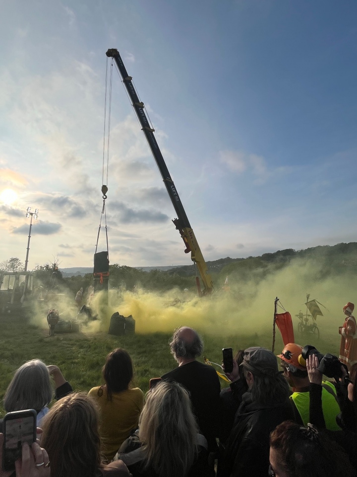 The first, the Gurdy Stone, has been standing on Lovebrook Farm near Kingston-near-Lewes in East Sussex since 29th April 2023, when it was dedicated at a Caught By The River event at nearby St Pancras Church. Each stone has a sound system built in, so visitors can feel the vibrations when it is energised.
During installation in 2023, Cauty and Finer used transducers to play their creation The Hurdy-Gurdy Song through the slab as it went up - in their framing, the song is now 'encoded' in the stone.
The song is frankly rather headache-inducing, though redeemed by the Extended Remix, a twenty-minute ambient dronescape from our friends at Stone Club which is well worth a listen.
The recent Hurdy Stone has been energised with Twa Sisters, an eleven-minute setting of Child Ballad 10 sung by Iona Zajac with Daragh Lynch of Lankum on guitar, Finer on hurdy-gurdy, and Cauty contributing processed radio bulletins. A third stone is yet to come. Apparently the trio is intended to triangulate with the Green Comet, on its return to Earth in 49,997 years.
So all in all a fun project from two musicians, both denied a Christmas Number One in their day, go to the trouble of transporting Welsh slate across England and standing it up. There is a long Portal tradition of taking new megaliths as seriously as old ones, and the Hurdy-Gurdy Stones sit comfortably here.
And the ley line claim
The artists have, with the wryness one would expect, framed their work in ley line terms. Cauty and Finer have noted that the Gurdy Stone's location allegedly sits on a "modern ley line" said to run through every Amazon fulfilment centre in the country, and now that the Hurdy Stone has been raised, they have created a new conceptual ley line between the two - of which we will hear more soon, no doubt.We took this as an invitation.
In the spirit of Cauty and Finer's own Hurdy-Gurdy Line, our new 'Ley Line' and Alignment Finder will draw a straight line between any two of the Portal's mapped sites and tell you what else sits along it. This is intended as a conceptual art project intended to highlight how we project modern thoughts onto ancient sites. What it says about the sites, the line, or any conclusions you might want to reach is for you to decide.
We know ley lines are an interest of some Portal visitors - and have intrigued readers more widely since Alfred Watkins published The Old Straight Track a hundred years ago this year. Whether you find Watkins' ancient trackways a serious proposition, or you read John Michell and Hamish Miller and treat the lines as something rather more, or like us you fall on the sceptical side with Tom Williamson and the statistical critics - the question of what actually sits along a given alignment is a perfectly answerable one. The Portal happens to know the location of more than 65,000 ancient sites. So we built a tool.
The new 'Ley Line' and Alignment Finder
UPDATE: We now have a simpler to use version all on one page try it here: Ley Line and Alignment Finder. This doesn't currently save the line to your visit log but you can bookmark the page to return to.Our 'Ley Line' and Alignment Finder is now live. You'll need to be logged in to your Megalithic Portal account to try it and a contributory membership to use it long term. We've included a preview image below. The idea is straightforward (a step-by-step how-to follows below): log a visit at any two sites, marking them as a single outing, then open that outing's page. A small card appears under the map: Draw a straight line on the map to find alignments between these two sites. Tick the box and the Finder draws a straight line between your two sites and surfaces every ancient site in the Portal database within your chosen distance of that line.

The *Distance from line* dropdown is what you'll spend most time tweaking. We've offered four options:
- 50m - strict. Only the tightest alignments survive.
- 100m - Watkins-faithful. Roughly the width of a pencil line on a 1-inch Ordnance Survey map, which is what Watkins was actually working with.
- 250m - loose. More matches, more chance hits.
- 500m - very loose. Mostly chance alignments at this width.
Any sites close enough to the line - within whatever tolerance you've chosen - appear on the map as glowing yellow markers. Below the map, a sortable table lists them in order along the line, showing how far off the line each one sits and how far along it they fall. The two sites you picked appear as the first and last rows, in bold, so the table reads as an itinerary. Each entry links straight to its Portal page.
One exclusion is worth mentioning. Sites whose Portal coordinates are recorded only to the nearest town or village (a small minority of entries) are left out - they're not precise enough to test a ley line claim, and including them would generate spurious hits. Everything else is fair game.
There are two further tickboxes once the Finder is on. *Show Prehistoric Sites Only* narrows the results to a curated whitelist of pre-Roman site types - barrows, hillforts, stone circles, dolmens, brochs and similar - and excludes later Portal entries such as holy wells, Christian carved stones and modern stone circles. *Show All sites within 10km of the line* takes the opposite approach: it widens the search dramatically, surfacing every Portal site in a 20-km-wide corridor (10 km each side) around your line. The point of that second mode isn't alignment-finding; it's to show how densely populated with ancient sites a typical strip of British landscape really is - which is the right context for thinking about what any close-to-the-line hit actually amounts to.
You can share the URL of any line you've drawn - it remembers your settings and keeps the line showing, so anyone clicking your link sees exactly what you saw.
A practical caveat for non-members: a free preview lasts ten minutes. After that, the Finder asks you to support the Portal by upgrading to a Contributory membership. Existing society members have unlimited use as you'd expect.
That's the tool. The interesting part is what it shows.
Line one - the Hurdy-Gurdy Stones
A line between the Hurdy Stone (Stroud) and the Gurdy Stone (East Sussex) runs across southern England. At 50m tolerance just one site comes up along the entire 181-kilometre line, and that just one site comes up is quite striking, "Cosmically significant", even, in the wry register Cauty and Finer's project tends to invite. Mapledurwell Bowl Barrow sits 23 metres off the straight line between the two Stones - a Bronze Age round barrow on a line drawn for purposes that have nothing to do with barrows. We have made the artists aware. Should they ever want a focus for future rituals, here it is.See the Hurdy-Gurdy line live in the Alignment Finder ▸ (login required)
The line itself is, of course, incidental. The Hurdy and Gurdy Stones stand where willing hosts could be found at a festival, not where any great master plan placed them. The Mapledurwell barrow's builders were not thinking about Stroud or East Sussex three thousand years before either was a place name. With more than 65,000 mapped sites in the Portal database, a 181-kilometre line across southern England will catch one or two close-ish hits on chance alone.
For wider context: the 20-kilometre corridor along this line (10 km each side) holds 265 other sites from the Portal - a density worth bearing in mind when assessing any one alignment hit.
Line Two - the canonical St Michael bearing
This is the one most readers will be curious about.The St Michael Line was first articulated by John Michell in *The View Over Atlantis* (1969). Michell drew it as a straight line, in the Watkins tradition, running from St Michael's Mount in Cornwall north-east across England on the May Day sunrise azimuth, taking in Brent Tor, Burrow Mump, Glastonbury Tor, Avebury, the Cotswolds and Bury St Edmunds.
Twenty years later, Hamish Miller and Paul Broadhurst's *The Sun and the Serpent* (1989) reframed the line entirely. Working with dowsing rods rather than rulers, they tracked two intertwining "currents" - Michael and Mary - that are explicitly *not* straight, but wind their way through the same general corridor of sites in a serpentine path. The 1989 book is what gave the line its modern Michael-and-Mary terminology.
These are two distinct claims, and only one of them can be tested with a straight-line tool. The Finder is the right instrument for Michell's 1969 alignment. It is, by design, the wrong instrument for Miller and Broadhurst's serpentine currents - their lines are not straight, and a tool that draws straight lines cannot evaluate them.
We cannot quite test the canonical line as drawn - the Portal does not yet have a page for the church at Hopton-on-Sea, nor for Burrow Mump, although both may join us in due course. There is a wider caveat here too: the Portal's scope is prehistoric and ancient sites - stone circles and barrows, hillforts and brochs, holy wells, rock art, Roman remains, ruined chapels, and much else - but it does not, as a rule, cover later parish churches. Most St Michael dedications across England and Cornwall therefore sit outside our remit, unless they are demonstrably built on earlier sacred ground. Adding every English parish church would not be a Portal task; it would be a different project, and a much larger one. The Finder therefore gives an honest read of the prehistoric and ancient record along the bearing, not of the saint-dedication overlay that gives the line its name. Instead we used the Portal site closest to the canonical bearing at the Norfolk end, Eastlow Hill, an artificial mound in Suffolk just east of Bury St Edmunds. It sits 241m off the true Hopton bearing - close enough to draw the line in approximately the canonical direction over its 494-kilometre length. We set the tolerance at a generous 250m.
See the St Michael line live in the Alignment Finder ▸ (login required)

The Finder returns 22 ancient sites along the line. Four patterns are worth pausing on.
An eastern barrow thread. Less heralded but no less real, six sites cluster along the eastern leg before the line reaches Dartmoor. Six Hills in Hertfordshire (53m off, just south of Stevenage), the Grim's Ditch Barrows in Buckinghamshire (177m off), Swyncombe Downs Earthwork in Oxfordshire (213m off), The Warrior Barrows in Oxfordshire (242m off), Fox Barrow in Berkshire (186m off), and The Hanging Stone (Wiltshire) (192m off). Five barrow groups and a Wiltshire menhir, spread across 130 kilometres of southern England, and not one of them previously claimed for the St Michael Line. They are all on the line.
The Dartmoor cluster. Six entries from the Shovel Down complex appear within 250m of the line at around 370 km from St Michael's Mount, alongside Cut Hill Stone Row (a remote and only re-discovered-in-2004 Bronze Age row at over 600 m altitude), Stonetor Hill Ring Cairn, the Kestor Settlement and the Modern Stone Circle near Kestor Rock. The line passes through one of England's richest Bronze Age ceremonial landscapes within a thousand-metre strip.
Holy wells. Three are within 250m of the line: Jerusalem Well in Wiltshire (133m off), Vincent's Well in Cornwall (156m off), and Giant's Well sitting practically at the foot of St Michael's Mount itself (33m off).
A curiosity for completeness: the Royal Cornwall Museum in Truro sits 82m off the line. The museum holds many of the Bronze Age finds from the very landscape the bearing crosses, which is the kind of coincidence one is allowed to enjoy without drawing any conclusions from.
The famous intermediates aren't on Michell's line. Avebury, Glastonbury Tor, Brent Tor, Burrow Mump - all named in the original 1969 claim - are between three and ten kilometres off any straight line you can draw between St Michael's Mount and the Norfolk coast. As a strict alignment in the Watkins tradition, the line does not survive.
This is not the Portal saying so for the first time. Tom Williamson and Liz Bellamy made the same observation in their 1983 book Ley Lines in Question. Their point - and ours - is that Michell's straight-line claim does not hold up to a strict test, and that in a country with many hundreds of St Michael churches and high places, drawing a line between any two prominent ones will catch a handful of others by chance. With more than 65,000 mapped sites in the Portal database, *any* 500-kilometre line in southern England will yield some hits at 250m tolerance.
It is perhaps not a coincidence that Miller and Broadhurst, publishing six years after Williamson and Bellamy, reframed the line as winding currents rather than a straight alignment. Whether or not by design, the move sidesteps the strict-test critique entirely - it recasts the claim as something a strict test cannot check.
So the honest finding is two-headed. Yes, the bearing Michell drew crosses a real concentration of ancient ceremonial sites - not Avebury or Glastonbury, but Shovel Down and the Dartmoor complexes, plus a coherent thread of holy wells, plus the eastern barrow thread we hadn't seen named anywhere before. No, the famous Avebury / Glastonbury / Brent Tor alignment that the original 1969 book put forward is not a straight line in any strict sense - though Miller and Broadhurst's later serpentine reframing is, by their own definition, untestable by a tool like the Finder.
For wider context: the 20-kilometre corridor along this line holds 1,481 other Portal sites - of all four lines we tested, the densest country.
Line three - Watkins' founding ley
This is perhaps where we should have started.
When Watkins set out his ley theory in 1925, the prime example he gave - the one that opens chapter four of The Old Straight Track and carries the argumentative weight of the book - was an alignment running from Stonehenge through Old Sarum and Salisbury Cathedral to Clearbury Ring and on to Frankenbury Camp in Hampshire. Four ancient sites, plus a medieval cathedral founded on an earlier sacred site, in a straight line over 27 kilometres.
All four sites have Portal pages. We set the tolerance strict at 100m. And the result, frankly, did surprise us:
| Site | Type | Distance from line |
|---|---|---|
| Stonehenge | Stone Circle | on the line itself |
| Old Sarum | Iron Age hillfort | 37m |
| Clearbury Ring | Iron Age hillfort | 20m |
| Frankenbury | Iron Age hillfort | on the line itself |
See the Watkins line live in the Alignment Finder ▸ (login required)
All four canonical points sit within 50 metres of a straight line. At Watkins' own pencil-on-1-inch-OS-map distance, the founding alignment lands as he drew it. Salisbury Cathedral, which Watkins also placed on the line, isn't currently in the Portal (medieval ecclesiastical sites are outside our usual scope, though the cathedral was built on the site of a Romano-British and earlier settlement and is generally accepted as on Watkins' line).
The Finder, run a century later on data Watkins would not have dreamed of, reproduces the four prehistoric points to the metre.
For wider context: even on this short 27-kilometre line, the 20-kilometre corridor holds 83 other Portal sites. Wessex is well-stocked.
Line four - Pentre Ifan to Stonehenge
We close with one more line, this time a Robin Heath-adjacent test. Heath has long argued that Stonehenge was modelled on the Preseli Wheel - the geometric arrangement of monuments around Pentre Ifan in west Wales. He does not, strictly, draw a single straight ley line between the two; the connection in his work is more geometric than directional. So we drew the implied straight line ourselves and ran it.The line runs 223 kilometres from Pentre Ifan in Pembrokeshire to Stonehenge in Wiltshire. We set the tolerance strict at 100m - Watkins-faithful.
See the Pentre Ifan to Stonehenge line live in the Alignment Finder ▸ (login required)
The result, frankly, surprised us:
| Site | Type | Distance from line |
|---|---|---|
| Pentre Ifan | Portal Tomb | on the line itself |
| Craig Rhosyfelin | Rock Outcrop (bluestone source) | 32m |
| Rhyd-y-Gath | Early Christian Sculptured Stone | 70m |
| Graig Llwyn Iron Age Fort | Hillfort | 35m |
| Cadbury Camp | Hillfort | 29m |
| Amesbury Cursus (W) | Cursus | 98m |
| Fargo Disk Barrow | Round Barrow | 63m |
| Stonehenge Car Park Postholes | Timber Circle | 88m |
| Stonehenge | Stone Circle | on the line itself |
Seven intermediate sites within 100 metres of a 223-kilometre line, at the strict Watkins-faithful tolerance.
Craig Rhosyfelin sits 32 metres off the line, 1.9 kilometres from Pentre Ifan. It is the rock outcrop identified by Mike Parker Pearson and colleagues in 2015 as one of the geological sources of Stonehenge's bluestones. A straight line between Pentre Ifan in west Wales and Stonehenge in Wessex passes within 32 metres of one of the spots from which some of Stonehenge's stones were extracted. Make of that what you will.
There is more. The line crosses two Iron Age hillforts in the middle - Graig Llwyn in Mid Glamorgan (35m off, 122 km in) and Cadbury Camp in Somerset (29m off, 150 km in) - and clips the Stonehenge complex at three points beyond the henge itself: the western terminal of the Amesbury Cursus (98m off), the Fargo Disk Barrow (63m off), and the famous Stonehenge Car Park Postholes (88m off), the Mesolithic timber alignment that predates Stonehenge by some four thousand years. The Stonehenge end of our line, in other words, is not a single point but a cluster of features, all of which sit within 100 metres of the bearing.
Whatever drew the bluestones across more than two hundred kilometres of country to Stonehenge - and the route by which they came is one of the genuinely open questions in British archaeology - the straight line that joins the two end points happens to pass within 100 metres of seven other Portal sites. Make of that what you will.
For wider context: the 20-kilometre corridor along this line holds 620 other Portal sites - the seven within 100m sit inside that wider population.
What the data tells us
Four lines, four different stories.The Hurdy-Gurdy line gives us a single striking hit (Mapledurwell at 23m). The artists have been informed.
The canonical St Michael bearing gives us a real concentration of ancient ceremonial sites along a 500-kilometre axis - but not the famous intermediates. The line as drawn by Michell is a corridor several kilometres wide, not a straight alignment, and that is worth saying out loud. There are also genuine sub-patterns within it (the Dartmoor cluster, the holy-well thread) that the original literature did not focus on, and that the Finder makes visible.
Watkins' founding ley reproduces in the data: four-of-four canonical points within 50 metres of a straight line, on data Watkins did not have.
The Pentre Ifan to Stonehenge line picks up seven sites at 100-metre distance, including Craig Rhosyfelin (one of Stonehenge's bluestone sources, 32m off the line), two Iron Age hillforts, and a cluster around the Stonehenge end.
We do not draw a conclusion from any of these. The Finder is a conceptual art project before it is anything else, and a tool for showing-rather-than-telling at that. It tells you what sits along a line at the distance you choose, and leaves the interpretation to you.
Proposed Prehistoric Alignments
The four lines above test ideas that may or may not have been in the minds of the people who built the sites involved. Two further lines are worth running through the Finder for contrast - alignments that were deliberately laid out by their builders, and are accepted as such by archaeologists today.The Kilmartin Glen linear cemetery
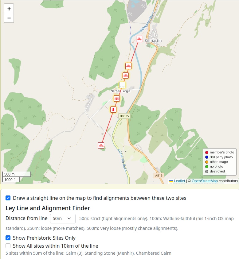
In Argyll, five Bronze Age cairns sit in a roughly north-south line through the floor of Kilmartin Glen - one of the most-cited examples in Britain of a cemetery deliberately arranged as an alignment. Drawing the Finder line from Glebe Cairn at the north end to Ri Cruin at the south, set strict at 50m and with the prehistoric filter on:
See the Kilmartin alignment live in the Alignment Finder ▸ (login required)
| Site | Type | Distance from line |
|---|---|---|
| Glebe Cairn | Cairn | on the line itself |
| Nether Largie North | Cairn | 18m |
| Nether Largie Mid | Cairn | 5m |
| Nether Largie Lost Cairn | Cairn | 6m |
| Nether Largie South | Chambered Cairn | 19m |
| Nether Largie standing stone | Standing Stone | 11m |
| Ri Cruin | Cairn | on the line itself |
Five intermediate features within 19 metres of a 2-kilometre line - and they are exactly the cairns and standing stone that make up the cemetery. This is what an archaeologically-confirmed prehistoric alignment looks like in the data: dense, tight, and unmistakably on-bearing.
The Dorset Cursus
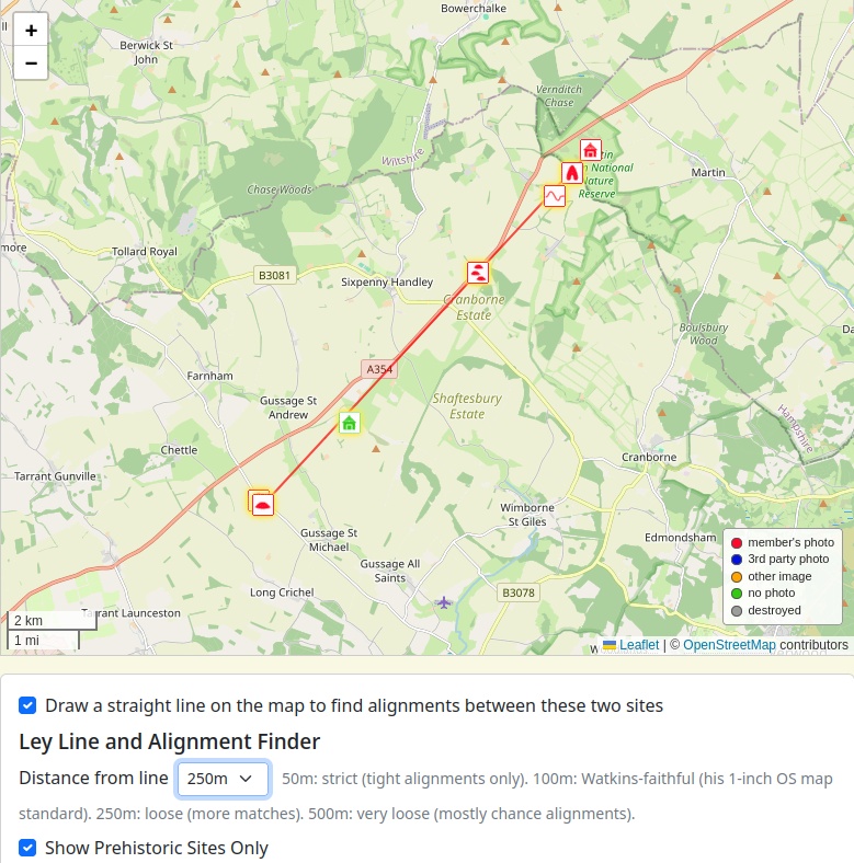
The Dorset Cursus is a Neolithic earthwork - twin parallel banks and ditches running roughly 10 kilometres north-east across Cranborne Chase, dated to around 3300 BCE. It is one of the longest prehistoric alignments in Europe. We drew the Finder line from Thickthorn Down (South) at the south-west terminal to the Martin Down Enclosure at the north-east, at 250m with the prehistoric filter on:
See the Dorset Cursus alignment live in the Alignment Finder ▸ (login required)
| Site | Type | Distance from line |
|---|---|---|
| Thickthorn Down (South) | Long Barrow | on the line itself |
| Thickthorn Round Barrows | Round Barrows | 0m |
| Thickthorn Down (North) | Long Barrow | 141m |
| Gussage Hill | Ancient Settlement | 174m |
| Oakley Down Barrows | Barrow Cemetery | 1m |
| Bokerley Dyke | Misc. Earthwork | 90m |
| Pentridge 3 | Long Barrow | 45m |
| Martin Down Enclosure | Ancient Settlement | on the line itself |
Six intermediate prehistoric features along the 10-kilometre cursus, including the famous Oakley Down barrow cemetery at one metre off the line - a detail it would be hard to place there by chance. The Cursus reads in the Finder exactly as the archaeology says it should: a deliberately-built alignment threading together monuments that share its bearing.
Why these matter
Run alongside the four lines above, the Kilmartin and Dorset results are useful as a reference. They show what the Finder produces when pointed at a landscape that was, in fact, deliberately laid out as an alignment - dense, tight, multiple on-line hits. Compare that to what the Hurdy-Gurdy line produced when pointed at a 181-kilometre stretch that nobody had any plan for, and the difference is visible. The Finder's job is to make that visible difference legible. What anyone wants to read into it is, as ever, their own affair.Try the Alignment finder for yourself
UPDATE: We now have a simpler to use version all on one page try it here: Ley Line and Alignment Finder. This doesn't currently save the line to your visit log but you can bookmark the page to return to.Anyone with a Megalithic Portal login can try the Alignment Finder. The simplest way is to log a two-site visit log between the sites you're curious about, then open the trip page. The card appears under the map. Tick the box.
Step-by-step instructions follow below, with example URLs you can copy and adapt.
How to create your own line between two ancient sites
The Alignment Finder lives on the Megalithic Portal's visit-log page. To use it you need to (a) log in to your Portal account, (b) make a visit log of exactly two sites with the same trip number, and (c) open that trip's page.Step by step
1. Log in to the Portal at the usual place. If you don't yet have a free account, the registration link is on that page.2. Find two sites you want to draw a line between. Use our search or browse our interactive maps to find them.
If you'd like a starting point from the ley-line literature, here are a few pairs worth trying:
- Aconbury Hill and Garway Hill - Watkins' own Herefordshire territory, both featured in The Old Straight Track.
- St Michael's Mount and Glastonbury Tor - the famous short fragment of the canonical St Michael bearing.
- Belas Knap and the Rollright Stones - a Cotswold long-barrow-to-stone-circle line worth checking.
Or pick anything else that intrigues you - the Finder takes any two Portal sites anywhere in the world.
3. Log a visit at each of the two sites. On any site page, click I have visited (again you will need to be logged in). The trip number now auto-fills with your current trip, and the order within the trip auto-numbers as you go - two visits in a row will both land on the same trip without your needing to think about it. To start a new trip, just bump the trip number up by one in the form.
A small honesty caveat: the form defaults to I have visited, which is a slight fib if you're using the Finder to test an alignment between sites you haven't actually been to. Either accept the small inaccuracy in your visit log (the line gets drawn either way), or edit the sites to Like to Visit and edit each one afterwards to add the same trip number. The finder will still work as long as both site are set to the same setting
4. Open your visit log. Go to your visit log - the two sites you just logged will be there together as a trip.
5. Look under the map. A section titled Ley Line and Alignment Finder should appear, with a tickbox: Draw a straight line on the map to find alignments between these two sites. Tick it. The line is drawn, and the table of sites within distance populates below.
6. Adjust the Distance from line dropdown to compare strict (50m) vs Watkins-faithful (100m) vs loose (250m, 500m). Two further tickboxes appear once the Finder is on: Show Prehistoric Sites Only and Show All sites within 10km of the line (the latter is for surveying density rather than testing alignment).
7. Share by copying the page web link (URL) - it carries the active state, so the recipient sees the same line you do as long as they are logged in to the Portal. Alternatively you can screenshot the page
Adding the Watkins line yourself
Let us follow exactly the recipe above with the line that started it all.The two sites at each end are Stonehenge and Frankenbury. Both are in the Portal already, which means you can adopt the trip directly without logging visits yourself - copy our trip URL for a one-click view.
If you want to make your *own* trip on the same line, the steps are:
1. Open the Stonehenge page, click *I have visited* and save. The trip and site numbers auto-fill - you do not need to set them.
2. Open the Frankenbury page, click *I have visited* and save. Both visits land on the same trip automatically.
3. Open your visit log - the two sites will be there together as a trip.
4. Tick the *Draw a straight line* box under the map, and set *Distance from line* to 100m for the Watkins-faithful test.
The result, regardless of which of us makes the trip, is the same:
- Old Sarum, 37m off the line
- Clearbury Ring, 20m off the line
Both Iron Age hillforts. Stonehenge and Frankenbury define the line itself. Four-of-four within 50m at the strict Watkins tolerance - the founding ley reproduced a hundred years on.
Try other lines
Once you have the technique, the same recipe works for anything. Two famous Wessex sites? Stonehenge and Avebury at 100m on a short, dense line. Try one of Robin Heath's proposed Welsh alignments by picking sites at either end in the Preselis. Try an alignment in your own country.View some recent two site visit logs created by other members. Can you find any interesting alignments?
IMPORTANT: We make no claim about what these lines will or won't show. The Finder simply tells you what is embedded in our data, at the line width you pick. What you do with that is up to you.
- Andy B
Note: Following the live premier last night at Lewes Catalyst Club here is the link to the brand new app version of the Ley Line Finder free for all to try for one week! Let us know if you find any new alignments


 We would like to know more about this location. Please feel free to add a brief description and any relevant information in your own language.
 Wir möchten mehr über diese Stätte erfahren. Bitte zögern Sie nicht, eine kurze Beschreibung und relevante Informationen in Deutsch hinzuzufügen.
 Nous aimerions en savoir encore un peu sur les lieux. S'il vous plaît n'hesitez pas à ajouter une courte description et tous les renseignements pertinents dans votre propre langue.
 Quisieramos informarnos un poco más de las lugares. No dude en añadir una breve descripción y otros datos relevantes en su propio idioma.