<< Our Photo Pages >> Wizard's Well - Holy Well or Sacred Spring in England in Cheshire
Submitted by vicky on Monday, 29 March 2004 Page Views: 41640
Springs and Holy WellsSite Name: Wizard's WellCountry: England County: Cheshire Type: Holy Well or Sacred Spring
Nearest Town: Wilmslow Nearest Village: Alderley Edge
Map Ref: SJ858778 Landranger Map Number: 118
Latitude: 53.296962N Longitude: 2.214511W
Condition:
| 5 | Perfect |
| 4 | Almost Perfect |
| 3 | Reasonable but with some damage |
| 2 | Ruined but still recognisable as an ancient site |
| 1 | Pretty much destroyed, possibly visible as crop marks |
| 0 | No data. |
| -1 | Completely destroyed |
| 5 | Superb |
| 4 | Good |
| 3 | Ordinary |
| 2 | Not Good |
| 1 | Awful |
| 0 | No data. |
| 5 | Can be driven to, probably with disabled access |
| 4 | Short walk on a footpath |
| 3 | Requiring a bit more of a walk |
| 2 | A long walk |
| 1 | In the middle of nowhere, a nightmare to find |
| 0 | No data. |
| 5 | co-ordinates taken by GPS or official recorded co-ordinates |
| 4 | co-ordinates scaled from a detailed map |
| 3 | co-ordinates scaled from a bad map |
| 2 | co-ordinates of the nearest village |
| 1 | co-ordinates of the nearest town |
| 0 | no data |
Internal Links:
External Links:
I have visited· I would like to visit
cappy greenboatgirl would like to visit
30081978 visited on 20th Sep 2024 - their rating: Cond: 3 Amb: 3 Access: 3
")
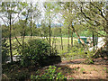
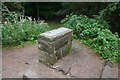
The spring itself is undoubtedly much earlier and is perhaps one of the reasons why the area was settled as early as the Neolithic period.
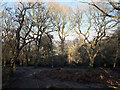
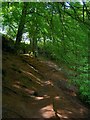
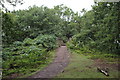
The well is easily accessed by parking in the small lay-by on the Macclesfield Road (rather than the main National Trust carpark) at SJ855778. From the layby, a short walk down the footpath will bring you to Castle Rock where a Neolithic settlement was discovered in the early 20th century. Turn left and follow the path down hill and you will soon come to the Wizard's Well.
Other sites of interest on the Edge include the Bronze Age copper Mines, the Armada Beacon constructed on top of a Bronze Age barrow, the Golden Stone and the Druid's Circle, a relatively modern folly also reputedly created by Robert Garner.
You may be viewing yesterday's version of this page. To see the most up to date information please register for a free account.
")
")
")
")
Do not use the above information on other web sites or publications without permission of the contributor.
Nearby Images from Geograph Britain and Ireland:
©2010(licence)
©2009(licence)
©2019(licence)
©2011(licence)
©2011(licence)
The above images may not be of the site on this page, they are loaded from Geograph.
Please Submit an Image of this site or go out and take one for us!
Click here to see more info for this site
Nearby sites
Key: Red: member's photo, Blue: 3rd party photo, Yellow: other image, Green: no photo - please go there and take one, Grey: site destroyed
Download sites to:
KML (Google Earth)
GPX (GPS waypoints)
CSV (Garmin/Navman)
CSV (Excel)
To unlock full downloads you need to sign up as a Contributory Member. Otherwise downloads are limited to 50 sites.
Turn off the page maps and other distractions
Nearby sites listing. In the following links * = Image available
100m S 180° Armada Beacon* Round Barrow(s) (SJ858777)
116m ENE 59° Holy Well (Alderley Edge)* Holy Well or Sacred Spring (SJ85907786)
223m ESE 116° Wishing Well (Alderley Edge)* Holy Well or Sacred Spring (SJ860777)
280m E 86° Wizard's Cave Cave or Rock Shelter (SJ86087782)
281m ENE 73° Druidical Circle* Modern Stone Circle etc (SJ86077788)
356m NE 38° Findlow Marker Stone (SJ86027808)
360m ESE 124° Golden Stone (Alderley Edge)* Standing Stone (Menhir) (SJ861776)
360m ESE 124° Engine Vein, Alderley Edge Copper Mines* Ancient Mine, Quarry or other Industry (SJ861776)
1.1km SSE 162° Great Merestone Marker Stone (SJ86137677)
1.7km ENE 69° Mottram St Andrew Mines Ancient Mine, Quarry or other Industry (SJ874784)
3.3km S 183° Birtles Hall Round Barrow(s) (SJ856745)
4.2km SSW 202° Sodger's Hump* Round Barrow(s) (SJ842739)
4.4km ESE 102° St Peter (Prestbury)* Ancient Cross (SJ9008676910)
4.7km ENE 66° Adlington Hall pre-Norman cross* Ancient Cross (SJ901797)
4.7km SE 124° Prestbury Road (Macclesfield)* Ancient Cross (SJ89727511)
4.9km E 84° Bonis Hall Lane* Round Barrow(s) (SJ907783)
4.9km E 84° Butley Barrow* Round Barrow(s) (SJ9072278334)
5.1km SSW 197° Capesthorne Hall (NE)* Round Barrow(s) (SJ843729)
5.2km E 88° Butley Stone Circle (SJ9178)
5.2km SSW 202° Capesthorne Hall (NW) Round Barrow(s) (SJ838730)
5.3km WNW 295° Lindow* Ancient Trackway (SJ810800)
5.4km SSW 194° Capesthorne Hall (SE)* Round Barrow(s) (SJ845726)
5.8km SSE 150° New Farm, Henbury* Stone Circle (SJ887728)
6.0km ESE 123° Macclesfield Cemetery* Round Barrow(s) (SJ908745)
6.0km SSE 164° Bearhurst Farm* Round Barrow(s) (SJ874720)
View more nearby sites and additional images


 We would like to know more about this location. Please feel free to add a brief description and any relevant information in your own language.
 Wir möchten mehr über diese Stätte erfahren. Bitte zögern Sie nicht, eine kurze Beschreibung und relevante Informationen in Deutsch hinzuzufügen.
 Nous aimerions en savoir encore un peu sur les lieux. S'il vous plaît n'hesitez pas à ajouter une courte description et tous les renseignements pertinents dans votre propre langue.
 Quisieramos informarnos un poco más de las lugares. No dude en añadir una breve descripción y otros datos relevantes en su propio idioma.