<< Our Photo Pages >> Golden Stone (Alderley Edge) - Standing Stone (Menhir) in England in Cheshire
Submitted by vicky on Tuesday, 23 July 2002 Page Views: 12181
Neolithic and Bronze AgeSite Name: Golden Stone (Alderley Edge)Country: England County: Cheshire Type: Standing Stone (Menhir)
Nearest Town: Wilmslow Nearest Village: Alderley Edge
Map Ref: SJ861776 Landranger Map Number: 118
Latitude: 53.295173N Longitude: 2.210001W
Condition:
| 5 | Perfect |
| 4 | Almost Perfect |
| 3 | Reasonable but with some damage |
| 2 | Ruined but still recognisable as an ancient site |
| 1 | Pretty much destroyed, possibly visible as crop marks |
| 0 | No data. |
| -1 | Completely destroyed |
| 5 | Superb |
| 4 | Good |
| 3 | Ordinary |
| 2 | Not Good |
| 1 | Awful |
| 0 | No data. |
| 5 | Can be driven to, probably with disabled access |
| 4 | Short walk on a footpath |
| 3 | Requiring a bit more of a walk |
| 2 | A long walk |
| 1 | In the middle of nowhere, a nightmare to find |
| 0 | No data. |
| 5 | co-ordinates taken by GPS or official recorded co-ordinates |
| 4 | co-ordinates scaled from a detailed map |
| 3 | co-ordinates scaled from a bad map |
| 2 | co-ordinates of the nearest village |
| 1 | co-ordinates of the nearest town |
| 0 | no data |
Internal Links:
External Links:
I have visited· I would like to visit
TimPrevett has visited here
 (PID:353)")
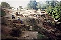
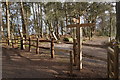
The Golden Stone lies close to the Engine Vein in Alderley Edge, where Bronze Age man worked the earth for its copper-rich ores. Displays in the visitors centre report that the Golden Stone was possibly a Bronze Age standing stone, later re-used as a boundary marker.
Looking at this strangely-shaped, pebbly, sandstone boulder today, it is hard to see how it would have stood, but given its position in the landscape in close proximity to the prehistoric copper workings and tumuli, it surely must have had some significance during Bronze Age times.
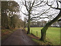
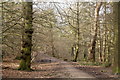
Access: Park in the National Trust car park and take the path from The Wizard Inn past the warden’s cottage and the eastern end of the Engine Vein. At the end, follow the track round to the right (to the south-east) towards Edge House Farm and you will see the Golden Stone to the left of the path after a few metres.
You may be viewing yesterday's version of this page. To see the most up to date information please register for a free account.
 (PID:231125)")
 (PID:219502)")
 (PID:32703)")
Do not use the above information on other web sites or publications without permission of the contributor.
Nearby Images from Geograph Britain and Ireland:
©2010(licence)
©2012(licence)
©2017(licence)
©2009(licence)
©2017(licence)
The above images may not be of the site on this page, they are loaded from Geograph.
Please Submit an Image of this site or go out and take one for us!
Click here to see more info for this site
Nearby sites
Key: Red: member's photo, Blue: 3rd party photo, Yellow: other image, Green: no photo - please go there and take one, Grey: site destroyed
Download sites to:
KML (Google Earth)
GPX (GPS waypoints)
CSV (Garmin/Navman)
CSV (Excel)
To unlock full downloads you need to sign up as a Contributory Member. Otherwise downloads are limited to 50 sites.
Turn off the page maps and other distractions
Nearby sites listing. In the following links * = Image available
nankm 0° Engine Vein, Alderley Edge Copper Mines* Ancient Mine, Quarry or other Industry (SJ861776)
141m NW 315° Wishing Well (Alderley Edge)* Holy Well or Sacred Spring (SJ860777)
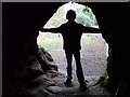
221m N 355° Wizard's Cave Cave or Rock Shelter (SJ86087782)
281m N 354° Druidical Circle* Modern Stone Circle etc (SJ86077788)
315m WNW 288° Armada Beacon* Round Barrow(s) (SJ858777)
328m NW 322° Holy Well (Alderley Edge)* Holy Well or Sacred Spring (SJ85907786)
360m WNW 304° Wizard's Well* Holy Well or Sacred Spring (SJ858778)
486m N 350° Findlow Marker Stone (SJ86027808)
830m S 178° Great Merestone Marker Stone (SJ86137677)
1.5km ENE 58° Mottram St Andrew Mines Ancient Mine, Quarry or other Industry (SJ874784)
3.1km S 189° Birtles Hall Round Barrow(s) (SJ856745)
4.0km E 100° St Peter (Prestbury)* Ancient Cross (SJ9008676910)
4.2km SSW 207° Sodger's Hump* Round Barrow(s) (SJ842739)
4.4km SE 124° Prestbury Road (Macclesfield)* Ancient Cross (SJ89727511)
4.5km ENE 62° Adlington Hall pre-Norman cross* Ancient Cross (SJ901797)
4.6km E 81° Bonis Hall Lane* Round Barrow(s) (SJ907783)
4.7km E 81° Butley Barrow* Round Barrow(s) (SJ9072278334)
4.9km E 85° Butley Stone Circle (SJ9178)
5.0km SSW 201° Capesthorne Hall (NE)* Round Barrow(s) (SJ843729)
5.1km SSW 206° Capesthorne Hall (NW) Round Barrow(s) (SJ838730)
5.2km SSW 198° Capesthorne Hall (SE)* Round Barrow(s) (SJ845726)
5.5km SSE 151° New Farm, Henbury* Stone Circle (SJ887728)
5.6km ESE 123° Macclesfield Cemetery* Round Barrow(s) (SJ908745)
5.6km WNW 295° Lindow* Ancient Trackway (SJ810800)
5.7km SSE 167° Bearhurst Farm* Round Barrow(s) (SJ874720)
View more nearby sites and additional images


 We would like to know more about this location. Please feel free to add a brief description and any relevant information in your own language.
 Wir möchten mehr über diese Stätte erfahren. Bitte zögern Sie nicht, eine kurze Beschreibung und relevante Informationen in Deutsch hinzuzufügen.
 Nous aimerions en savoir encore un peu sur les lieux. S'il vous plaît n'hesitez pas à ajouter une courte description et tous les renseignements pertinents dans votre propre langue.
 Quisieramos informarnos un poco más de las lugares. No dude en añadir una breve descripción y otros datos relevantes en su propio idioma.