Featured: Hare and Tabor T Shirts for discerning antiquarians

Hare and Tabor T Shirts for discerning antiquarians

Random Image


Vale de Rodrigo 3

Ancestral Geographies of the Neolithic, Edmonds, Bender

Ancestral Geographies of the Neolithic, Edmonds, Bender

Who's Online

There are currently, 466 guests and 1 members online.

You are a guest. To join in, please register for free by clicking here

Sponsors

<< Our Photo Pages >> Sheldon (Aberdeenshire) - Stone Circle in Scotland in Aberdeenshire

Submitted by mattchapman on Saturday, 18 October 2014  Page Views: 16638

Neolithic and Bronze AgeSite Name: Sheldon (Aberdeenshire)
Country: Scotland County: Aberdeenshire Type: Stone Circle

Map Ref: NJ82292494  Landranger Map Number: 38
Latitude: 57.314679N  Longitude: 2.295655W
Condition:
5Perfect
4Almost Perfect
3Reasonable but with some damage
2Ruined but still recognisable as an ancient site
1Pretty much destroyed, possibly visible as crop marks
0No data.
-1Completely destroyed
3 Ambience:
5Superb
4Good
3Ordinary
2Not Good
1Awful
0No data.
5 Access:
5Can be driven to, probably with disabled access
4Short walk on a footpath
3Requiring a bit more of a walk
2A long walk
1In the middle of nowhere, a nightmare to find
0No data.
3 Accuracy:
5co-ordinates taken by GPS or official recorded co-ordinates
4co-ordinates scaled from a detailed map
3co-ordinates scaled from a bad map
2co-ordinates of the nearest village
1co-ordinates of the nearest town
0no data
5

Internal Links:
External Links:

I have visited· I would like to visit

HaggisAction would like to visit

Chrus saw from a distance on 1st Jan 0000 - their rating: Cond: 4 Amb: 4 Access: 4 Field recently ploughed and muck spreaded so I was put off unfortunately

TheCaptain have visited here
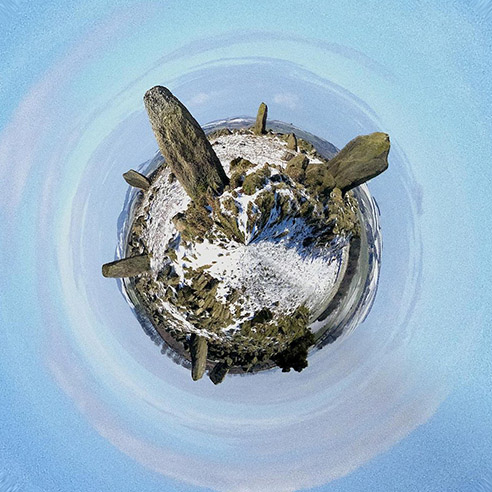
Little Planet Sheldon in the snow
Little Planet Sheldon in the snow submitted by golux : Sheldon Stone Circle on its own little snow-covered world. (Vote or comment on this photo)
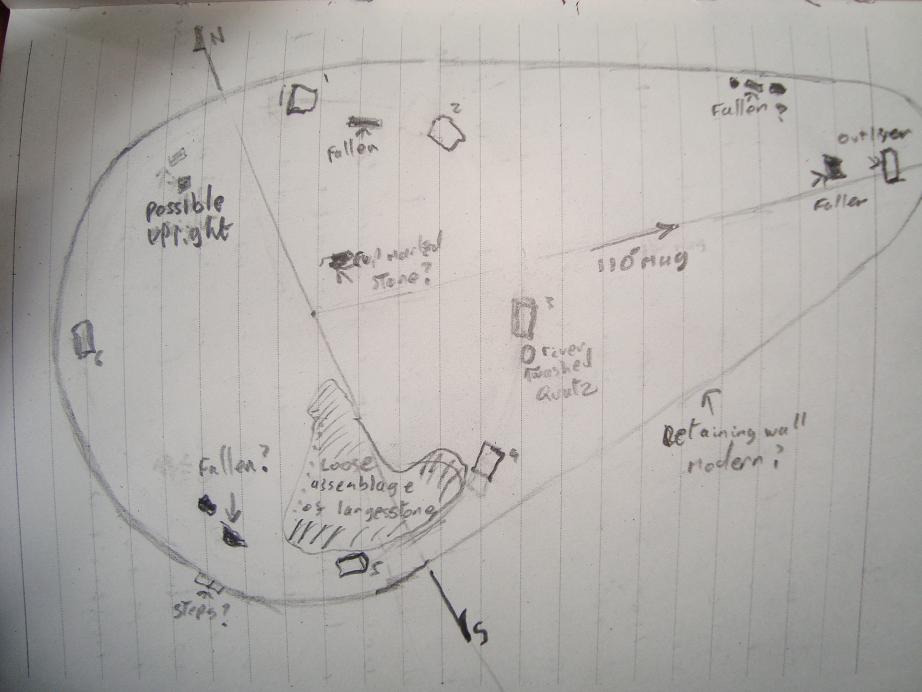
Six uprights visible. The area contains several prostrate stones several of which must be uprights and some broken stumps. the tallest upright 2 in the sketch below stands to the NE, while the smallest may be the fallen pair to the south east. Scattered around the site were three or four river washed quartz boulders the largest of which is adjacent to stone 3.

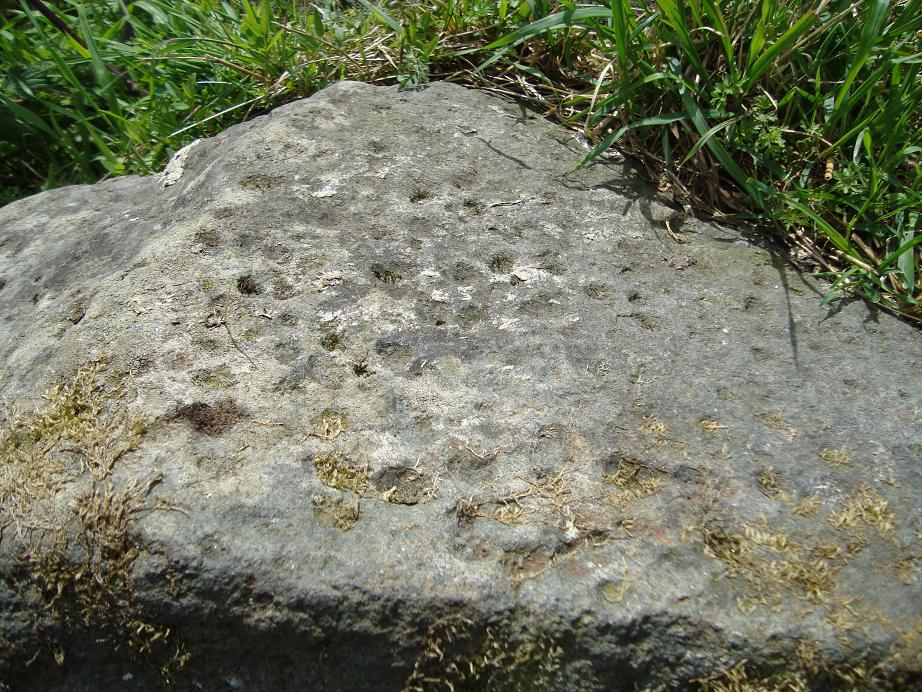
To the NE of the center is a stone about 2.5" by 1" that has what appear to be numerous small cup marks at one end . These may be natural although I couldn't find any more on the other stones. The stones littering the interior have a greater mass to the south and form three distinct piles here. But this may be field clearance debris.

To the east some yards from the center is a tall triangular upright. From the center I made this at 110 magnetic and just south of east. I'm not convinced its an equinoctial marker but its position from the circle and the magnificent horizons coupled with my rough pacing of the dimensions mean it would well be worth being there at the right time , and the whole site placement seams to scream "Observatory" when you sit there.

The whole area is bordered by a dry stone wall using both rough and dressed stones in its construction. To the SW the appear to be steps built in to this wall to all access to be made easier and as such I guess this is modern - ish. Magnificent site. Sorry for the roughness of the plan taken from my field notes. All distances based on my pace. I'm 5'10". Text by mattchapman.

Note: Sheldon stone circle as a little planet, with snow. More planets by Golux in our Art gallery
You may be viewing yesterday's version of this page. To see the most up to date information please register for a free account.

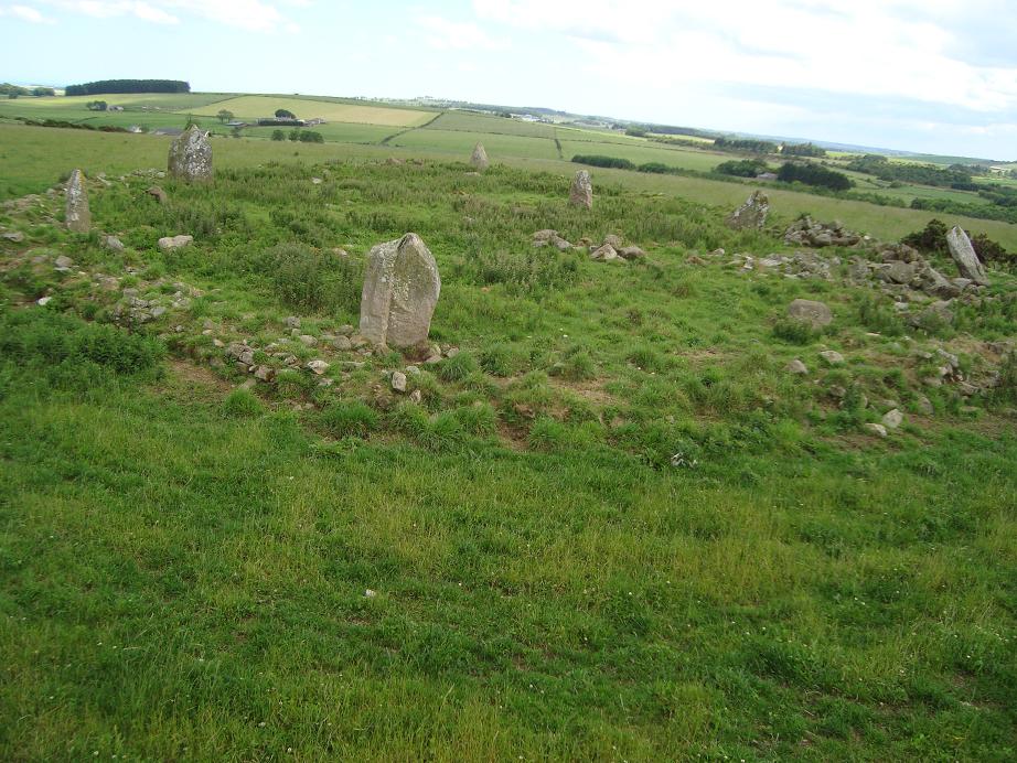
Sheldon (Aberdeenshire)
Sheldon (Aberdeenshire) submitted by mattchapman : Cup marked stone in the center. (2 comments - Vote or comment on this photo)

Sheldon (Aberdeenshire)
Sheldon (Aberdeenshire) submitted by golux : Panorama from the middle of the circle, centred on the view looking south, with Bennachie on the skyline. The second stone from the left is the cone-shaped outlier. (1 comment - Vote or comment on this photo)

Sheldon (Aberdeenshire)
Sheldon (Aberdeenshire) submitted by mattchapman : Again looking east from the stick cam. (Vote or comment on this photo)

Sheldon (Aberdeenshire)
Sheldon (Aberdeenshire) submitted by mattchapman : Rough sketch plan of site. (Vote or comment on this photo)

Sheldon (Aberdeenshire)
Sheldon (Aberdeenshire) submitted by cosmic : The East Outlier. This stone is some 20m away from the circle's circumference. (Vote or comment on this photo)

Sheldon (Aberdeenshire)
Sheldon (Aberdeenshire) submitted by cosmic : The Big North Stone If this was a recumbent stone circle then you would expect the smallest stone to be at the North end but at Sheldon the North stone is the biggest (and there's no sign of a recumbent). (3 comments)

Sheldon (Aberdeenshire)
Sheldon (Aberdeenshire) submitted by cosmic : View along the north side from the west.

Sheldon (Aberdeenshire)
Sheldon (Aberdeenshire) submitted by cosmic : Sheldon from the west

Sheldon (Aberdeenshire)
Sheldon (Aberdeenshire) submitted by Postman : I've ran out of things to say, just come and have a look at Sheldon stone circle it's a good one, hmm apparently I didn't.

Sheldon (Aberdeenshire)
Sheldon (Aberdeenshire) submitted by Postman : One of Sheldons stone has a Yellowhammer on it.

Sheldon (Aberdeenshire)
Sheldon (Aberdeenshire) submitted by Postman : We only came here because it's close to Kirkton of Bourtie, but I'm thinking I've got that the wrong way round now.

Sheldon (Aberdeenshire)
Sheldon (Aberdeenshire) submitted by Postman : The rolling verdance of Aberdeenshire

Sheldon (Aberdeenshire)
Sheldon (Aberdeenshire) submitted by Postman : This stone is big but that stone is far away

Sheldon (Aberdeenshire)
Sheldon (Aberdeenshire) submitted by Postman : The decidedly triangular outlier stone

Sheldon (Aberdeenshire)
Sheldon (Aberdeenshire) submitted by Postman : Looking over the circle to Tap o' Noth and Benachie

Sheldon (Aberdeenshire)
Sheldon (Aberdeenshire) submitted by Postman : Considering all the farm land around it's weathered rather well

Sheldon (Aberdeenshire)
Sheldon (Aberdeenshire) submitted by Postman : I'm not sure if this was a recumbent stone circle, there's certainly no recumbent stone now.

Sheldon (Aberdeenshire)
Sheldon (Aberdeenshire) submitted by Postman : Bazinga ! Have you seen the big bang theory?

Sheldon (Aberdeenshire)
Sheldon (Aberdeenshire) submitted by TheCaptain : Once there, the circle has been left to become very overgrown, and was chest high in nettles and other such things, meaning entering the circle was impossible. What a pity there is no group like CASPN up here to keep all these wonderful sites clear.

Sheldon (Aberdeenshire)
Sheldon (Aberdeenshire) submitted by TheCaptain

Sheldon (Aberdeenshire)
Sheldon (Aberdeenshire) submitted by TheCaptain

Sheldon (Aberdeenshire)
Sheldon (Aberdeenshire) submitted by TheCaptain : Despite having seen nice pictures of this stone circle, it was a big let down. To get to it meant a longish walk through firstly a manure dump, and after that a field full of growing root vegetables, meaning a wet detour along the tractor tramlines to get to the top of the hill.

Sheldon (Aberdeenshire)
Sheldon (Aberdeenshire) submitted by TheCaptain

Sheldon (Aberdeenshire)
Sheldon (Aberdeenshire) submitted by golux : Plan drawn from a survey in 1999, reproduced in Great Crowns of Stone Appendix 1. I have enlarged the text to make it legible in this small size.

Sheldon (Aberdeenshire)
Sheldon (Aberdeenshire) submitted by josvg : Site plan from "Megalithic sites in Britain" - A. Thom - Oxford University Press 1967, edition 1976, page 59bottom. Canmore site no. 63691

These are just the first 25 photos of Sheldon (Aberdeenshire). If you log in with a free user account you will be able to see our entire collection.

Do not use the above information on other web sites or publications without permission of the contributor.
Click here to see more info for this site

Nearby sites

Click here to view sites on an interactive OS map

Key: Red: member's photo, Blue: 3rd party photo, Yellow: other image, Green: no photo - please go there and take one, Grey: site destroyed

Download sites to:
KML (Google Earth)
GPX (GPS waypoints)
CSV (Garmin/Navman)
CSV (Excel)

To unlock full downloads you need to sign up as a Contributory Member. Otherwise downloads are limited to 50 sites.

Paul Kenyon`s Database by Paul Kenyon


Turn off the page maps and other distractions

Nearby sites listing. In the following links * = Image available
 1.8km W 267° Bourtie Pictish Stone* Class I Pictish Symbol Stone (NJ80462485)
 2.1km WNW 291° Hill of Barra* Hillfort (NJ803257)
 2.2km W 268° Kirkton Of Bourtie* Stone Circle (NJ80092488)
 5.0km SW 224° Keith Hall* Class I Pictish Symbol Stone (NJ78802136)
 5.0km SE 136° St Mary's Well (Straloch)* Holy Well or Sacred Spring (NJ858213)
 5.9km S 182° Peathill* Standing Stone (Menhir) (NJ8210419068)
 6.0km SW 236° Carnegie Museum (Inverurie)* Museum (NJ773216)
 6.1km SW 224° Inverurie 1* Class I Pictish Symbol Stone (NJ78022063)
 6.3km W 259° East Balhalgardy* Class I Pictish Symbol Stone (NJ76082379)
 6.4km W 264° Balhalgardy Stone Circle* Stone Circle (NJ759243)
 6.4km SW 231° Conyng Hillock Artificial Mound (NJ773209)
 6.7km WNW 303° Daviot Symbol Stone* Class I Pictish Symbol Stone (NJ76652862)
 6.7km SW 220° Broomend of Crichie North circle Stone Circle (NJ779198)
 6.8km WSW 248° Brandsbutt stone circle* Stone Circle (NJ76012240)
 6.8km WSW 248° Brandsbutt* Class I Pictish Symbol Stone (NJ7599222403)
 6.8km SW 219° Broomend Of Crichie Stone Circle / Henge* Henge (NJ77911968)
 6.8km SW 219° Broomend of Crichie Pictish Symbol Stone* Class I Pictish Symbol Stone (NJ77921967)
 6.8km SW 219° Broomend of Crichie Avenue* Multiple Stone Rows / Avenue (NJ7791419653)
 6.9km SW 219° Broomend of Crichie Stone Row / Alignment (NJ7792119591)
 7.0km SW 218° Broomend of Crichie Row Mid Stone Row / Alignment (NJ7792919479)
 7.1km WSW 241° Blackhall Roundabout* Modern Stone Circle etc (NJ76072155)
 7.2km SW 217° Gardeners House Standing Stone Standing Stone (Menhir) (NJ7794919226)
 7.2km S 188° Greenlands* Ancient Village or Settlement (NJ81231778)
 7.3km SW 217° Broomend Stone Seat / Cists* Cist (NJ77871917)
 7.4km WSW 244° Blackhall Stones* Modern Stone Circle etc (NJ75602173)
View more nearby sites and additional images

<< Bygland Phallic Stones

Haugar Barrows >>

Please add your thoughts on this site

Great Crowns of Stone: The Recumbent Stone Circles of Scotland

Great Crowns of Stone: The Recumbent Stone Circles of Scotland

Archived Web links for Sheldon (Aberdeenshire)

Paul Kenyon`s Database by Paul Kenyon

Sponsors

Auto-Translation (Google)

Translate from English into:

"Sheldon (Aberdeenshire)" | Login/Create an Account | 8 News and Comments
  
Go back to top of page    Comments are owned by the poster. We aren't responsible for their content.
Re: Sheldon by TheCaptain on Thursday, 27 July 2017
(User Info | Send a Message)
Notes from my visit October 2016.

Returning to Aberdeen at the end of a day visiting stone circles, before I get to the main road I pass another hilltop stone circle marked on the map, which is looking very tempting so I decide to go have a look while there was still a bit of light left.

Despite having seen nice pictures of this stone circle, it was a big let down. To get to it meant a longish walk through firstly a manure dump, and after that a field full of growing root vegetables, meaning a wet detour along the tractor tramlines to get to the top of the hill.

Once there, the circle has been left to become very overgrown, and was chest high in nettles and other such things, meaning entering the circle was impossible. I could make out a circle of stones with an outlier, but saw no sign of where the recumbent would be, assuming there is one.

What a pity there is no group like CASPN up here to keep all these wonderful sites clear.
[ Reply to This ]

Re: Sheldon by Anonymous on Friday, 24 October 2014
Like the other circle at Bourtie, this one has suffered from farmers' disregard. It looks as though the broader layout has been ploughed-out.
Here's a thing though: the North stone is a ringing stone (like the one at Glen Gairn). That must have been carried from somewhere.
[ Reply to This ]
    Re: Sheldon by golux on Friday, 24 October 2014
    (User Info | Send a Message)
    This circle and its two outliers are surrounded by a low wall which bars any ploughing. The furrows which run across the site are old rigs not plough furrows.
    Why do you think the north stone must have been carried from somewhere?
    [ Reply to This ]

Re: Sheldon by mattchapman on Saturday, 24 September 2011
(User Info | Send a Message)
Rain, cloud and Bullocks at the Equinox. B****r
[ Reply to This ]

Re: Sheldon by mattchapman on Sunday, 14 August 2011
(User Info | Send a Message)
Visited 01 July 11. All distances based on my pace. I'm 5'10". Roughly yards in diameter With Six uprights visible. The area contains several prostrate stones several of which must be uprights and some broken stumps. the tallest upright 2 in the sketch stands to the NE while the smallest may be the fallen pair to the south east.Scattered around the site were three or four river washed quartz boulders the largest of which is adjacent to stone 3. To the N E of the center is a stone about 2.5" by 1" that has what appear to be numerous small cup marks at one end . These may be natural although I couldn't find any more on the other stones. The stones littering the interior have a greater mass to the south and form three distinct piles here. But this may be field clearance debris.
To the east some yards from the center is a tall triangular upright. From the center I made this at 110 magnetic and just south of east. I'm not convinced its an equinoctial marker but its position from the circle and the magnificent horizons coupled with my rough pacing of the dimensions mean it would well be worth being there at the right time , and the whole site placement seams to scream "Observatory" when you sit there. The whole area is bordered by a dry stone wall using both rough and dressed stones in its construction. To the SW the appear to be steps built in to this wall to all access to be made easier and as such I guess this is modern - ish. Magnificent site. Sorry for the roughness of the plan taken from My field notes.

Condition : 3
Ambiance : 5
Access: 3 ( across a filed from the road. Please don't shoot when I revisit!)
Accuracy : N 57.31472 W 2.29575 Elevation 189m ( Garmin vehicle sat Nav)
[ Reply to This ]

Re: Sheldon by golux on Sunday, 23 May 2010
(User Info | Send a Message)
Condition: 3
Ambience: 5
Access: 3

Great hilltop location with superb views all round, from Aberdeen to Bennachie.
[ Reply to This ]

Re: Sheldon by golux on Saturday, 15 May 2010
(User Info | Send a Message)
Condition: 3
Ambience: 5
Access: 3
[ Reply to This ]

Re: Sheldon by coldrum on Monday, 05 April 2010
(User Info | Send a Message)
Street View


View Larger Map
[ Reply to This ]

Your Name: Anonymous [ Register Now ]
Subject:


Add your comment or contribution to this page. Spam or offensive posts are deleted immediately, don't even bother

<<< What is five plus one as a number? (Please type the answer to this question in the little box on the left)
You can also embed videos and other things. For Youtube please copy and paste the 'embed code'.
For Google Street View please include Street View in the text.
Create a web link like this: <a href="https://www.megalithic.co.uk">This is a link</a>  

Allowed HTML is:
<p> <b> <i> <a> <img> <em> <br> <strong> <blockquote> <tt> <li> <ol> <ul> <object> <param> <embed> <iframe>

We would like to know more about this location. Please feel free to add a brief description and any relevant information in your own language.
Wir möchten mehr über diese Stätte erfahren. Bitte zögern Sie nicht, eine kurze Beschreibung und relevante Informationen in Deutsch hinzuzufügen.
Nous aimerions en savoir encore un peu sur les lieux. S'il vous plaît n'hesitez pas à ajouter une courte description et tous les renseignements pertinents dans votre propre langue.
Quisieramos informarnos un poco más de las lugares. No dude en añadir una breve descripción y otros datos relevantes en su propio idioma.