<< Our Photo Pages >> Hill of Barra - Hillfort in Scotland in Aberdeenshire
Submitted by bobs on Friday, 18 March 2005 Page Views: 16054
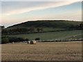
Iron Age and Later PrehistorySite Name: Hill of Barra Alternative Name: Barra HillCountry: Scotland County: Aberdeenshire Type: Hillfort
Map Ref: NJ803257
Latitude: 57.321424N Longitude: 2.328752W
Condition:
| 5 | Perfect |
| 4 | Almost Perfect |
| 3 | Reasonable but with some damage |
| 2 | Ruined but still recognisable as an ancient site |
| 1 | Pretty much destroyed, possibly visible as crop marks |
| 0 | No data. |
| -1 | Completely destroyed |
| 5 | Superb |
| 4 | Good |
| 3 | Ordinary |
| 2 | Not Good |
| 1 | Awful |
| 0 | No data. |
| 5 | Can be driven to, probably with disabled access |
| 4 | Short walk on a footpath |
| 3 | Requiring a bit more of a walk |
| 2 | A long walk |
| 1 | In the middle of nowhere, a nightmare to find |
| 0 | No data. |
| 5 | co-ordinates taken by GPS or official recorded co-ordinates |
| 4 | co-ordinates scaled from a detailed map |
| 3 | co-ordinates scaled from a bad map |
| 2 | co-ordinates of the nearest village |
| 1 | co-ordinates of the nearest town |
| 0 | no data |
Internal Links:
External Links:
I have visited· I would like to visit
golux visited on 1st Jan 2011 - their rating: Cond: 2 Amb: 4 Access: 2 Access by sign-posted route (1.15km): from the roundabout on the S side of Oldmeldrum where the B97170 meets the bypass, walk N as if entering Oldmeldrum and take the first right onto the surfaced road running S towards Hill of Barra; at the first house (which rejoices in the name "Blankets") take the path S through the woodland, cross the fence by the stile and continue S along the field edge; cross the footbridge, cross the fence by the stile then continue S following the fence towards the hilltop. Beware cattle and electrified fences.
(Contrary to the caption below bobs' photo, no gorse bushes are involved!)
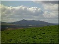
Great views to N and W, well worth the 15 minute walk on a fine day.
megalithicmatt visited on 31st Jul 2008 - their rating: Cond: 3 Amb: 4 Access: 3 Covers quite a big area. Earthworks are fairly visible.
Average ratings for this site from all visit loggers: Condition: 2.5 Ambience: 4 Access: 2.5
")
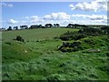
Note: Cosmic writes: This Hill Fort has three clear ramparts and encloses an area over 400 feet by 300 feet.
You may be viewing yesterday's version of this page. To see the most up to date information please register for a free account.
")
")
Do not use the above information on other web sites or publications without permission of the contributor.
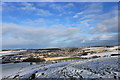
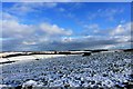
Nearby Images from Geograph Britain and Ireland:
©2016(licence)
©2016(licence)
©2008(licence)
©2008(licence)
©2018(licence)
The above images may not be of the site on this page, they are loaded from Geograph.
Please Submit an Image of this site or go out and take one for us!
Click here to see more info for this site
Nearby sites
Key: Red: member's photo, Blue: 3rd party photo, Yellow: other image, Green: no photo - please go there and take one, Grey: site destroyed
Download sites to:
KML (Google Earth)
GPX (GPS waypoints)
CSV (Garmin/Navman)
CSV (Excel)
To unlock full downloads you need to sign up as a Contributory Member. Otherwise downloads are limited to 50 sites.
Turn off the page maps and other distractions
Nearby sites listing. In the following links * = Image available
845m SSW 194° Kirkton Of Bourtie* Stone Circle (NJ80092488)
864m S 169° Bourtie Pictish Stone* Class I Pictish Symbol Stone (NJ80462485)
2.1km ESE 111° Sheldon (Aberdeenshire)* Stone Circle (NJ82292494)
4.6km SSW 199° Keith Hall* Class I Pictish Symbol Stone (NJ78802136)
4.6km WSW 252° Balhalgardy Stone Circle* Stone Circle (NJ759243)
4.6km WSW 245° East Balhalgardy* Class I Pictish Symbol Stone (NJ76082379)
4.7km NW 308° Daviot Symbol Stone* Class I Pictish Symbol Stone (NJ76652862)
5.1km SW 216° Carnegie Museum (Inverurie)* Museum (NJ773216)
5.4km SW 232° Brandsbutt stone circle* Stone Circle (NJ76012240)
5.4km SW 232° Brandsbutt* Class I Pictish Symbol Stone (NJ7599222403)
5.6km SSW 204° Inverurie 1* Class I Pictish Symbol Stone (NJ78022063)
5.6km W 261° Liggar's Stane* Standing Stone (Menhir) (NJ74702488)
5.7km SSW 212° Conyng Hillock Artificial Mound (NJ773209)
5.8km WNW 295° Loanhead of Daviot S Stone Circle (NJ750282)
5.9km SW 225° Blackhall Roundabout* Modern Stone Circle etc (NJ76072155)
6.1km SW 229° Blackhall Stones* Modern Stone Circle etc (NJ75602173)
6.3km WNW 299° Loanhead Of Daviot* Stone Circle (NJ74772885)
6.4km SSW 202° Broomend of Crichie North circle Stone Circle (NJ779198)
6.4km WSW 250° Drimmies* Class I Pictish Symbol Stone (NJ74262350)
6.5km SSW 201° Broomend Of Crichie Stone Circle / Henge* Henge (NJ77911968)
6.5km SSW 201° Broomend of Crichie Pictish Symbol Stone* Class I Pictish Symbol Stone (NJ77921967)
6.5km SSW 201° Broomend of Crichie Avenue* Multiple Stone Rows / Avenue (NJ7791419653)
6.5km SSW 201° Broomend of Crichie Stone Row / Alignment (NJ7792119591)
6.6km SSW 201° Broomend of Crichie Row Mid Stone Row / Alignment (NJ7792919479)
6.9km SSE 165° Peathill* Standing Stone (Menhir) (NJ8210419068)
View more nearby sites and additional images


 We would like to know more about this location. Please feel free to add a brief description and any relevant information in your own language.
 Wir möchten mehr über diese Stätte erfahren. Bitte zögern Sie nicht, eine kurze Beschreibung und relevante Informationen in Deutsch hinzuzufügen.
 Nous aimerions en savoir encore un peu sur les lieux. S'il vous plaît n'hesitez pas à ajouter une courte description et tous les renseignements pertinents dans votre propre langue.
 Quisieramos informarnos un poco más de las lugares. No dude en añadir una breve descripción y otros datos relevantes en su propio idioma.