<< Our Photo Pages >> Ballymeanoch Kerb Cairn - Cairn in Scotland in Argyll
Submitted by caradoc68 on Sunday, 11 December 2011 Page Views: 5788
Neolithic and Bronze AgeSite Name: Ballymeanoch Kerb Cairn Alternative Name: BallymeanochCountry: Scotland County: Argyll Type: Cairn
Nearest Town: Lachgilphead Nearest Village: Kilmartin
Map Ref: NR8339596429
Latitude: 56.111345N Longitude: 5.48534W
Condition:
| 5 | Perfect |
| 4 | Almost Perfect |
| 3 | Reasonable but with some damage |
| 2 | Ruined but still recognisable as an ancient site |
| 1 | Pretty much destroyed, possibly visible as crop marks |
| 0 | No data. |
| -1 | Completely destroyed |
| 5 | Superb |
| 4 | Good |
| 3 | Ordinary |
| 2 | Not Good |
| 1 | Awful |
| 0 | No data. |
| 5 | Can be driven to, probably with disabled access |
| 4 | Short walk on a footpath |
| 3 | Requiring a bit more of a walk |
| 2 | A long walk |
| 1 | In the middle of nowhere, a nightmare to find |
| 0 | No data. |
| 5 | co-ordinates taken by GPS or official recorded co-ordinates |
| 4 | co-ordinates scaled from a detailed map |
| 3 | co-ordinates scaled from a bad map |
| 2 | co-ordinates of the nearest village |
| 1 | co-ordinates of the nearest town |
| 0 | no data |
Internal Links:
External Links:
I have visited· I would like to visit
Uralsdaughter visited on 19th Aug 2018 - their rating: Cond: 3 Amb: 4 Access: 4
Anne T visited on 18th Jul 2018 - their rating: Cond: 2 Amb: 4 Access: 4 Ballymeanoch Kerb Cairn: With a number of other cars pulling up in the car park with other people wanting to look at the cairn, we hastened down the marked path towards the stone row, wondering why there were large, fresh cowpats in the cordoned off pathway. We were shortly to be confronted by a large bullock who stood and stared at us, completely blocking the path. The wire fence between the field/woodland and the path had been knocked down and the cattle had invaded, some sitting by the gate. This bullock absolutely refused to move, and his other companions started to stir and look our way. Andrew tried to move it away, but it stood firm and looked as if it might charge. Even Andrew backed away at this point.
Fortunately, there was a gate into a field of pasture to our left hand side, so we let ourselves into that field of pasture and followed the fenced off path along on the wrong side of the fence. There was another gate, leading from a track from the road, into the standing stone field. This gate was next to a babbling stream with a stone bridge across. This field also had a large number of other large bullocks, but these continued grazing and took little notice of us until we got to the two standing stones at the far end, when they started to take a definite interest.
Having made sure we weren’t going to be under (immediate) danger of attack by the bullocks, we tiptoed carefully further into the field. Having read about the cairn in "In The Footsteps of Kings" booklet, I circled it and photographed it as best I could. The sun was intense, being low in the sky, and it was so hot I could have laid down on the ground and fallen asleep. However, time was pressing, so I gathered my courage and explored further.
SandyG visited on 15th Apr 2015 - their rating: Cond: 4 Amb: 5 Access: 4
coin visited on 1st Jan 2014 - their rating: Cond: 2 Amb: 4 Access: 3 :)
SolarMegalith visited on 28th Apr 2013 - their rating: Cond: 3 Amb: 4 Access: 4
markj99 visited on 30th Apr 2010 - their rating: Cond: 3 Amb: 5 Access: 3 Antiquarians are spoiled for choice in Kilmartin. Ballymeanoch complex is a worthwhile visit consisting of a kerb cairn, stone row, a stone pair and a henge. It requires some time and exploration to make sense of the complex. The concentration of sites in a small area implies that Ballymeanoch was important to the ancient people.
snakefarmer rrmoser have visited here
Average ratings for this site from all visit loggers: Condition: 2.83 Ambience: 4.33 Access: 3.67
The following information is from Canmore ID 39483: A ring of erect slabs, 17' in diameter, average height 3' (Campbell and Sandeman 1964) apparently the remains of the retaining wall of a barrow (information and photograph from G E Livock to OS, 1940). M Campbell and M Sandeman 1964.
This is a kerbed cairn comprising 11 stones. The interior contains recent field clearance. Resurveyed at 1:2500. Visited by OS (I A) 2 May 1973.
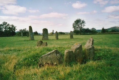
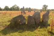
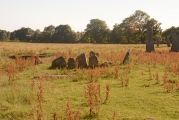
The remains of a kerbed cairn surviving as 11 earthfast slabs forming a circle 6.0m diameter enclosing a turf-covered stony mound 0.6m high. The slabs are almost continuous in the north quadrant but only a few remain elsewhere. In the west, two large stones lying adjacent to, and outside the circle appear to have been originally part of the kerb. About 135 m to the WNW of NR89NW 51, at the corner of an arable field and 29 m NE of the standing stones, there is a kerb-cairn (Campbell and Sandeman 1964). A drainage ditch has removed a small portion of the E arc of the cairn, but originally it was roughly circular on plan, measuring about 6.9 m in diameter over a kerb of upright boulders, and it now stands to a height of 0.7 m. Stone-robbing has reduced the number of kerbstones to eleven, and several of the remainder survive only as stumps; the stones of the kerb, however, appear to have been graded in height, with the tallest (up to 1.4 m high) on the SW.
This cairn is also featured in the Stone Rows of Great Britain's entry for the Ballymeanoch Stone Row, which includes a description, photographs of the cairn, simplified plans of the stone rows and their relationships to the cairns and the henge, plus links to other online resources.
You may be viewing yesterday's version of this page. To see the most up to date information please register for a free account.


Do not use the above information on other web sites or publications without permission of the contributor.
Click here to see more info for this site
Nearby sites
Key: Red: member's photo, Blue: 3rd party photo, Yellow: other image, Green: no photo - please go there and take one, Grey: site destroyed
Download sites to:
KML (Google Earth)
GPX (GPS waypoints)
CSV (Garmin/Navman)
CSV (Excel)
To unlock full downloads you need to sign up as a Contributory Member. Otherwise downloads are limited to 50 sites.
Turn off the page maps and other distractions
Nearby sites listing. In the following links * = Image available
31m SW 230° Ballymeanoch Stone Row* Stone Row / Alignment (NR83379641)
99m WSW 250° Ballymeanoch Rock Art* Rock Art (NR833964)
138m ESE 112° Ballymeanoch Cairn* Cairn (NR83529637)
171m SSW 207° Ballymeanoch Henge* Henge (NR83319628)
391m NNW 344° Dunchraigaig Cairn* Cairn (NR8330796811)
599m NNW 331° Baluachraig Rock Art* Rock Art (NR8312696966)
930m ESE 101° Ballymeanoch Dun Stone Fort or Dun (NR843962)
1.0km NE 39° Dun Mor, Dunchraigaig Stone Fort or Dun (NR841972)
1.1km NW 306° Ri Cruin* Cairn (NR8254897119)
1.1km NW 304° Ri Cruin* Rock Art (NR825971)
1.2km SSE 147° Rhudil Cairn (NR840954)
1.3km WSW 257° Rowanfield Cist* Cist (NR8216096208)
1.3km NNW 332° Nether Largie Stone Row* Stone Row / Alignment (NR8283197610)
1.4km NNW 332° Nether Largie standing stone* Standing Stone (Menhir) (NR82799773)
1.5km WSW 244° Rowanfield Cottage* Standing Stone (Menhir) (NR82059585)
1.5km WNW 295° Poltalloch Cist* Cist (NR82049714)
1.6km WNW 303° Cnoc-an-teallaidh* Cist (NR82129735)
1.6km NNW 337° Nether Largie South* Chambered Cairn (NR8286097920)
1.6km NNW 329° Temple Wood S* Stone Circle (NR8263197830)
1.6km NW 314° Bruach-na-cuirte* Cist (NR82309760)
1.6km NNW 330° Temple Wood N* Stone Circle (NR8265997856)
1.7km ESE 121° Baroile* Chambered Cairn (NR8477195498)
1.8km NNW 343° Nether Largie Lost Cairn* Cairn (NR82979815)
1.9km NNW 346° Nether Largie Mid* Cairn (NR8303798309)
2.1km NNW 349° Nether Largie North* Cairn (NR8309098470)
View more nearby sites and additional images


 We would like to know more about this location. Please feel free to add a brief description and any relevant information in your own language.
 Wir möchten mehr über diese Stätte erfahren. Bitte zögern Sie nicht, eine kurze Beschreibung und relevante Informationen in Deutsch hinzuzufügen.
 Nous aimerions en savoir encore un peu sur les lieux. S'il vous plaît n'hesitez pas à ajouter une courte description et tous les renseignements pertinents dans votre propre langue.
 Quisieramos informarnos un poco más de las lugares. No dude en añadir una breve descripción y otros datos relevantes en su propio idioma.