<< Our Photo Pages >> Ballymeanoch Cairn - Cairn in Scotland in Argyll
Submitted by Iain_P on Sunday, 06 August 2017 Page Views: 1053
Neolithic and Bronze AgeSite Name: Ballymeanoch Cairn Alternative Name: Ballymeanoch TumulusCountry: Scotland County: Argyll Type: Cairn
Nearest Village: Kilmartin
Map Ref: NR83529637
Latitude: 56.110873N Longitude: 5.483285W
Condition:
| 5 | Perfect |
| 4 | Almost Perfect |
| 3 | Reasonable but with some damage |
| 2 | Ruined but still recognisable as an ancient site |
| 1 | Pretty much destroyed, possibly visible as crop marks |
| 0 | No data. |
| -1 | Completely destroyed |
| 5 | Superb |
| 4 | Good |
| 3 | Ordinary |
| 2 | Not Good |
| 1 | Awful |
| 0 | No data. |
| 5 | Can be driven to, probably with disabled access |
| 4 | Short walk on a footpath |
| 3 | Requiring a bit more of a walk |
| 2 | A long walk |
| 1 | In the middle of nowhere, a nightmare to find |
| 0 | No data. |
| 5 | co-ordinates taken by GPS or official recorded co-ordinates |
| 4 | co-ordinates scaled from a detailed map |
| 3 | co-ordinates scaled from a bad map |
| 2 | co-ordinates of the nearest village |
| 1 | co-ordinates of the nearest town |
| 0 | no data |
Internal Links:
External Links:
")
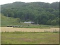
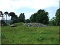
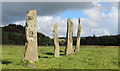
There's not much left to see of the cairn, but it's still recognisable as an ancient monument - I spotted it from the road before looking it up to confirm its identity - and what makes it special is its proximity to other sites. As you can see from the drone photos, it's very near the Ballymeanoch Stone Row, Henge and Kerb Cairn. Here's a link to the video which shows all 4 sites:
https://vimeo.com/228510581
A Scheduled Monument, designation number SM3342
You may be viewing yesterday's version of this page. To see the most up to date information please register for a free account.
")
")
")
Do not use the above information on other web sites or publications without permission of the contributor.
Nearby Images from Geograph Britain and Ireland:
©2012(licence)
©2009(licence)
©2011(licence)
©2009(licence)
©2011(licence)
The above images may not be of the site on this page, they are loaded from Geograph.
Please Submit an Image of this site or go out and take one for us!
Click here to see more info for this site
Nearby sites
Key: Red: member's photo, Blue: 3rd party photo, Yellow: other image, Green: no photo - please go there and take one, Grey: site destroyed
Download sites to:
KML (Google Earth)
GPX (GPS waypoints)
CSV (Garmin/Navman)
CSV (Excel)
To unlock full downloads you need to sign up as a Contributory Member. Otherwise downloads are limited to 50 sites.
Turn off the page maps and other distractions
Nearby sites listing. In the following links * = Image available
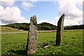
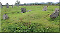
138m WNW 292° Ballymeanoch Kerb Cairn* Cairn (NR8339596429)
155m WNW 282° Ballymeanoch Stone Row* Stone Row / Alignment (NR83379641)
221m W 275° Ballymeanoch Rock Art* Rock Art (NR833964)
228m WSW 244° Ballymeanoch Henge* Henge (NR83319628)
489m NNW 331° Dunchraigaig Cairn* Cairn (NR8330796811)
713m NW 324° Baluachraig Rock Art* Rock Art (NR8312696966)
795m E 99° Ballymeanoch Dun Stone Fort or Dun (NR843962)
1.0km NNE 32° Dun Mor, Dunchraigaig Stone Fort or Dun (NR841972)
1.1km SSE 151° Rhudil Cairn (NR840954)
1.2km NW 305° Ri Cruin* Cairn (NR8254897119)
1.3km WNW 303° Ri Cruin* Rock Art (NR825971)
1.4km W 260° Rowanfield Cist* Cist (NR8216096208)
1.4km NNW 328° Nether Largie Stone Row* Stone Row / Alignment (NR8283197610)
1.5km ESE 122° Baroile* Chambered Cairn (NR8477195498)
1.5km NNW 329° Nether Largie standing stone* Standing Stone (Menhir) (NR82799773)
1.6km WSW 248° Rowanfield Cottage* Standing Stone (Menhir) (NR82059585)
1.7km WNW 295° Poltalloch Cist* Cist (NR82049714)
1.7km NNW 334° Nether Largie South* Chambered Cairn (NR8286097920)
1.7km WNW 302° Cnoc-an-teallaidh* Cist (NR82129735)
1.7km NW 326° Temple Wood S* Stone Circle (NR8263197830)
1.7km NNW 327° Temple Wood N* Stone Circle (NR8265997856)
1.7km NW 312° Bruach-na-cuirte* Cist (NR82309760)
1.9km NNW 340° Nether Largie Lost Cairn* Cairn (NR82979815)
2.0km NNW 343° Nether Largie Mid* Cairn (NR8303798309)
2.1km NNW 346° Nether Largie North* Cairn (NR8309098470)
View more nearby sites and additional images


 We would like to know more about this location. Please feel free to add a brief description and any relevant information in your own language.
 Wir möchten mehr über diese Stätte erfahren. Bitte zögern Sie nicht, eine kurze Beschreibung und relevante Informationen in Deutsch hinzuzufügen.
 Nous aimerions en savoir encore un peu sur les lieux. S'il vous plaît n'hesitez pas à ajouter une courte description et tous les renseignements pertinents dans votre propre langue.
 Quisieramos informarnos un poco más de las lugares. No dude en añadir una breve descripción y otros datos relevantes en su propio idioma.