

<< Our Photo Pages >> Ri Cruin - Rock Art in Scotland in Argyll
Submitted by andy_h on Tuesday, 11 March 2003 Page Views: 6618
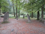
Rock ArtSite Name: Ri CruinCountry: Scotland County: Argyll Type: Rock Art
Nearest Town: Lochgilphead Nearest Village: Kilmartin
Map Ref: NR825971 Landranger Map Number: 55
Latitude: 56.116956N Longitude: 5.500251W
Condition:
| 5 | Perfect |
| 4 | Almost Perfect |
| 3 | Reasonable but with some damage |
| 2 | Ruined but still recognisable as an ancient site |
| 1 | Pretty much destroyed, possibly visible as crop marks |
| 0 | No data. |
| -1 | Completely destroyed |
| 5 | Superb |
| 4 | Good |
| 3 | Ordinary |
| 2 | Not Good |
| 1 | Awful |
| 0 | No data. |
| 5 | Can be driven to, probably with disabled access |
| 4 | Short walk on a footpath |
| 3 | Requiring a bit more of a walk |
| 2 | A long walk |
| 1 | In the middle of nowhere, a nightmare to find |
| 0 | No data. |
| 5 | co-ordinates taken by GPS or official recorded co-ordinates |
| 4 | co-ordinates scaled from a detailed map |
| 3 | co-ordinates scaled from a bad map |
| 2 | co-ordinates of the nearest village |
| 1 | co-ordinates of the nearest town |
| 0 | no data |
Internal Links:
External Links:
I have visited· I would like to visit
SandyG visited on 15th Apr 2015 - their rating: Cond: 3 Amb: 4 Access: 4
coin visited on 1st Jan 2014 - their rating: Cond: 4 Amb: 5 Access: 3
custer have visited here
Average ratings for this site from all visit loggers: Condition: 3.5 Ambience: 4.5 Access: 3.5
")
Have you visited this site? Please contribute a description or any thoughts by adding a comment.
You may be viewing yesterday's version of this page. To see the most up to date information please register for a free account.
")
")
")
")
")
")
")
")
")
")
")
")
")
")
")
")
")
")
")
")
")
")
")
")
These are just the first 25 photos of Ri Cruin. If you log in with a free user account you will be able to see our entire collection.
Do not use the above information on other web sites or publications without permission of the contributor.
Click here to see more info for this site
Nearby sites
Key: Red: member's photo, Blue: 3rd party photo, Yellow: other image, Green: no photo - please go there and take one, Grey: site destroyed
Download sites to:
KML (Google Earth)
GPX (GPS waypoints)
CSV (Garmin/Navman)
CSV (Excel)
To unlock full downloads you need to sign up as a Contributory Member. Otherwise downloads are limited to 50 sites.
Turn off the page maps and other distractions
Nearby sites listing. In the following links * = Image available
51m ENE 65° Ri Cruin* Cairn (NR8254897119)
453m WNW 300° Cnoc-an-teallaidh* Cist (NR82129735)
460m W 272° Poltalloch Cist* Cist (NR82049714)
538m NNW 335° Bruach-na-cuirte* Cist (NR82309760)
607m NNE 30° Nether Largie Stone Row* Stone Row / Alignment (NR8283197610)
638m E 99° Baluachraig Rock Art* Rock Art (NR8312696966)
692m NNE 22° Nether Largie standing stone* Standing Stone (Menhir) (NR82799773)
741m N 7° Temple Wood S* Stone Circle (NR8263197830)
771m N 9° Temple Wood N* Stone Circle (NR8265997856)
854m ESE 107° Dunchraigaig Cairn* Cairn (NR8330796811)
894m NNE 21° Nether Largie South* Chambered Cairn (NR8286097920)
953m SSW 198° Rowanfield Cist* Cist (NR8216096208)
1.1km SE 128° Ballymeanoch Rock Art* Rock Art (NR833964)
1.1km SE 126° Ballymeanoch Stone Row* Stone Row / Alignment (NR83379641)
1.1km NW 305° Ballygowan Rock Art* Rock Art (NR8162097782)
1.1km SE 124° Ballymeanoch Kerb Cairn* Cairn (NR8339596429)
1.1km NNE 21° Nether Largie Lost Cairn* Cairn (NR82979815)
1.1km SE 133° Ballymeanoch Henge* Henge (NR83319628)
1.3km ESE 123° Ballymeanoch Cairn* Cairn (NR83529637)
1.3km NNE 21° Nether Largie Mid* Cairn (NR8303798309)
1.3km SSW 197° Rowanfield Cottage* Standing Stone (Menhir) (NR82059585)
1.4km WSW 237° Poltalloch House Rock Art* Rock Art (NR813964)
1.4km NW 306° Dun Ballygowan Stone Fort or Dun (NR814980)
1.5km WNW 295° Barr A Chuirn Cairn (NR812978)
1.5km NNE 19° Nether Largie Cup Marks North Rock Art (NR83059847)
View more nearby sites and additional images


 We would like to know more about this location. Please feel free to add a brief description and any relevant information in your own language.
 Wir möchten mehr über diese Stätte erfahren. Bitte zögern Sie nicht, eine kurze Beschreibung und relevante Informationen in Deutsch hinzuzufügen.
 Nous aimerions en savoir encore un peu sur les lieux. S'il vous plaît n'hesitez pas à ajouter une courte description et tous les renseignements pertinents dans votre propre langue.
 Quisieramos informarnos un poco más de las lugares. No dude en añadir una breve descripción y otros datos relevantes en su propio idioma.