


<< Our Photo Pages >> Clach na h'Annait - Standing Stone (Menhir) in Scotland in Isle of Skye
Submitted by vicky on Sunday, 29 August 2004 Page Views: 12508
Neolithic and Bronze AgeSite Name: Clach na h'AnnaitCountry: Scotland
NOTE: This site is 0.2 km away from the location you searched for.
County: Isle of Skye Type: Standing Stone (Menhir)
Nearest Town: Broadford Nearest Village: Kilbride
Map Ref: NG58952029 Landranger Map Number: 32
Latitude: 57.209746N Longitude: 5.993374W
Condition:
| 5 | Perfect |
| 4 | Almost Perfect |
| 3 | Reasonable but with some damage |
| 2 | Ruined but still recognisable as an ancient site |
| 1 | Pretty much destroyed, possibly visible as crop marks |
| 0 | No data. |
| -1 | Completely destroyed |
| 5 | Superb |
| 4 | Good |
| 3 | Ordinary |
| 2 | Not Good |
| 1 | Awful |
| 0 | No data. |
| 5 | Can be driven to, probably with disabled access |
| 4 | Short walk on a footpath |
| 3 | Requiring a bit more of a walk |
| 2 | A long walk |
| 1 | In the middle of nowhere, a nightmare to find |
| 0 | No data. |
| 5 | co-ordinates taken by GPS or official recorded co-ordinates |
| 4 | co-ordinates scaled from a detailed map |
| 3 | co-ordinates scaled from a bad map |
| 2 | co-ordinates of the nearest village |
| 1 | co-ordinates of the nearest town |
| 0 | no data |
Internal Links:
External Links:
I have visited· I would like to visit
Uralsdaughter visited on 1st Jun 2019 - their rating: Cond: 4 Amb: 4 Access: 4
megalithicmatt visited on 30th Apr 2013 - their rating: Cond: 4 Amb: 3 Access: 4
markj99 visited on 11th Aug 2011 - their rating: Cond: 4 Amb: 4 Access: 4 It is possible to park up at NG 5947 2006 on the B8083. Walk c. 130 yards W to a junction with Kilbride House Private Road. Walk c. 130 yards down the private road to Kilbride House. There is a gateway on the right leading into a field. Walk W into the field for c. 50 yards then NW for 50 yards towards the standing stone near two trees.
kelpie have visited here
Average ratings for this site from all visit loggers: Condition: 4 Ambience: 3.67 Access: 4
")
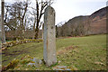
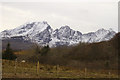
This standing stone appears in a field just off the road to Elgol.
Apparently there is little known of its history or why it bears a connection to Annait on the other side of the island. NG 58954 20295
You may be viewing yesterday's version of this page. To see the most up to date information please register for a free account.
")
")
Do not use the above information on other web sites or publications without permission of the contributor.
coldrum has found this location on Google Street View:
Nearby Images from Geograph Britain and Ireland:
©2011(licence)
©2011(licence)
©2011(licence)
©2008(licence)
©2008(licence)
The above images may not be of the site on this page, they are loaded from Geograph.
Please Submit an Image of this site or go out and take one for us!
Click here to see more info for this site
Nearby sites
Key: Red: member's photo, Blue: 3rd party photo, Yellow: other image, Green: no photo - please go there and take one, Grey: site destroyed
Download sites to:
KML (Google Earth)
GPX (GPS waypoints)
CSV (Garmin/Navman)
CSV (Excel)
To unlock full downloads you need to sign up as a Contributory Member. Otherwise downloads are limited to 50 sites.
Turn off the page maps and other distractions
Nearby sites listing. In the following links * = Image available
751m SE 137° High Pasture Cave* Cave or Rock Shelter (NG59431971)
1.5km WSW 249° Dun Beag (Loch Slapin)* Stone Fort or Dun (NG57511984)
1.6km W 261° Dun Mor (Torrin)* Broch or Nuraghe (NG57402015)
2.9km SSE 164° Dun Kearstack* Hillfort (NG596175)
3.0km E 87° Kilchrist, Glebe* Stone Circle (NG61972027)
3.4km NE 44° Buaile Nan Aodan Standing Stones (NG61452255)
4.1km ENE 62° Suardal* Chambered Cairn (NG62722203)
4.3km SW 217° Dun Ringill* Broch or Nuraghe (NG561170)
4.4km WSW 257° Abhainn Cille Mhaire Standing Stones (NG54611952)
4.7km SW 228° Cnocan nan Gobhar* Round Cairn (NG55261735)
4.8km SE 145° Dun Boreraig Fort* Hillfort (NG615162)
4.8km SW 227° Kilmarie (Strathaird) Stone Circle (NG552172)
4.8km WSW 240° Kilmarie Standing Stones (NG54591814)
4.9km SE 139° Dun Boreraig Stone* Standing Stone (Menhir) (NG61951638)
5.3km WSW 237° Na Clachan Bhreige* Stone Circle (NG5433817681)
5.4km SW 218° Cadha nan Ingrean* Stone Fort or Dun (NG55331625)
6.3km NE 53° Corry chambered cairn* Chambered Cairn (NG6416023780)
6.4km SW 218° An Reidhean* Stone Circle (NG54701548)
6.4km NE 49° Corry cist, cairn and souterrain Cist (NG641242)
6.5km ESE 108° Heaste Stone Standing Stone (Menhir) (NG6505117847)
7.4km SSE 155° Tobar Chaon* Holy Well or Sacred Spring (NG61711340)
7.6km SW 214° Dun Liath (Elgol)* Broch or Nuraghe (NG54331427)
7.6km SSE 155° Teampuill Chaon* Early Christian Sculptured Stone (NG61831321)
7.8km SSE 165° Inver Aulavaig 2* Cairn (NG6059112629)
7.8km SSE 166° Inver Aulavaig 1* Cairn (NG60441259)
View more nearby sites and additional images


 We would like to know more about this location. Please feel free to add a brief description and any relevant information in your own language.
 Wir möchten mehr über diese Stätte erfahren. Bitte zögern Sie nicht, eine kurze Beschreibung und relevante Informationen in Deutsch hinzuzufügen.
 Nous aimerions en savoir encore un peu sur les lieux. S'il vous plaît n'hesitez pas à ajouter une courte description et tous les renseignements pertinents dans votre propre langue.
 Quisieramos informarnos un poco más de las lugares. No dude en añadir una breve descripción y otros datos relevantes en su propio idioma.