Featured: Friendly specialist tours to ancient, mystical and historical sites in the UK and beyond

Friendly specialist tours to ancient, mystical and historical sites in the UK and beyond

Random Image


Gruline 2

Temples of Stone: Exploring the Megalithic Tombs of Ireland

Temples of Stone: Exploring the Megalithic Tombs of Ireland

Who's Online

There are currently, 646 guests and 3 members online.

You are a guest. To join in, please register for free by clicking here

Sponsors

<< Our Photo Pages >> High Pasture Cave - Cave or Rock Shelter in Scotland in Isle of Skye

Submitted by Andy B on Thursday, 05 April 2012  Page Views: 17401

Natural PlacesSite Name: High Pasture Cave Alternative Name: Uamh An Ard Achadh, Cave of the High Field
Country: Scotland County: Isle of Skye Type: Cave or Rock Shelter

Map Ref: NG59431971
Latitude: 57.204801N  Longitude: 5.984887W
Condition:
5Perfect
4Almost Perfect
3Reasonable but with some damage
2Ruined but still recognisable as an ancient site
1Pretty much destroyed, possibly visible as crop marks
0No data.
-1Completely destroyed
2 Ambience:
5Superb
4Good
3Ordinary
2Not Good
1Awful
0No data.
3 Access:
5Can be driven to, probably with disabled access
4Short walk on a footpath
3Requiring a bit more of a walk
2A long walk
1In the middle of nowhere, a nightmare to find
0No data.
3 Accuracy:
5co-ordinates taken by GPS or official recorded co-ordinates
4co-ordinates scaled from a detailed map
3co-ordinates scaled from a bad map
2co-ordinates of the nearest village
1co-ordinates of the nearest town
0no data
4

Internal Links:
External Links:

High Pasture Cave
High Pasture Cave submitted by dodomad : Ancient instrument discovered on Scottish island. Photo credit: Historic Scotland (Vote or comment on this photo)
Cave on the Isle of Skye. Recent excavations at the High Pasture Cave site have revealed a burial dating back to the Iron Age, the first of its kind on the island of Skye.

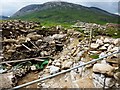
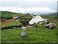
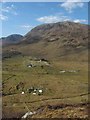
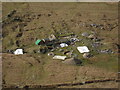
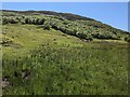
Discovered in 1972 by students from the University of London Speleological Society, Uamh An Ard Achadh (Cave of the High Field or High Pasture Cave) lies approximately 1km south east of Torrin in a shallow valley on the north side of Beinn an Dubhaich (Grid Reference NGR NG 594 197). The cave contains around 320m of accessible passages making it the second longest cave complex on Skye.

During the removal of the baulk that was left standing between Trenches 2 and 3, Martin Wildgoose uncovered small fragments of bone including part of a mandible containing two teeth. This was at first tentatively identified as human, due to the presence of other less diagnostic pieces of bone in the same sector of the trench. Soon afterwards he recovered a small object manufactured from antler, a possible ring-headed pin.

Approximate Grid Ref given, more details of the finds at the High Pasture Cave web site.


Note: Prehistoric stringed instrument found on Skye: "This is very much a step change. In Scotland it pushes the history of complex music back more than a thousand years"
You may be viewing yesterday's version of this page. To see the most up to date information please register for a free account.


High Pasture Cave
High Pasture Cave submitted by Creative Commons : A closer view of the Bronze age site clearly showing the layout of the enclosure. Copyright Paul Rose and licensed for reuse under the Creative Commons Licence. (Vote or comment on this photo)

High Pasture Cave
High Pasture Cave submitted by Creative Commons : This is just part of the archaeological excavation at High Pasture Cave (Uamh an Ard Achadh), near Kilbride on Skye. The site shows evidence of human activity mostly between the 7th century BC and the 1st century AD. Comparison with earlier geographs shows how much excavation has been carried out, and deep archaeological deposits have been found. These include the remains of an adult woman, ... (Vote or comment on this photo)

High Pasture Cave
High Pasture Cave submitted by Creative Commons : High Pasture Cave near to Kilbride Very interesting Bronze age settlement and natural cave complex Copyright Paul Rose and licensed for reuse under the Creative Commons Licence. (Vote or comment on this photo)

Do not use the above information on other web sites or publications without permission of the contributor.

Nearby Images from Geograph Britain and Ireland:
NG5919 : High Pasture Cave by Tony Fisher
by Tony Fisher
©2010(licence)
NG5919 : Uamh An Ard Achadh by John Allan
by John Allan
©2006(licence)
NG5919 : High Pasture Cave near to Kilbride by Paul Rose
by Paul Rose
©2008(licence)
NG5919 : High Pasture Cave near to Kilbride by Paul Rose
by Paul Rose
©2008(licence)
NG5919 : The slopes of Beinn an Dubhaich by David Medcalf
by David Medcalf
©2023(licence)

The above images may not be of the site on this page, they are loaded from Geograph.
Please Submit an Image of this site or go out and take one for us!


Click here to see more info for this site

Nearby sites

Click here to view sites on an interactive OS map

Key: Red: member's photo, Blue: 3rd party photo, Yellow: other image, Green: no photo - please go there and take one, Grey: site destroyed

Download sites to:
KML (Google Earth)
GPX (GPS waypoints)
CSV (Garmin/Navman)
CSV (Excel)

To unlock full downloads you need to sign up as a Contributory Member. Otherwise downloads are limited to 50 sites.


Turn off the page maps and other distractions

Nearby sites listing. In the following links * = Image available
 751m NW 317° Clach na h'Annait* Standing Stone (Menhir) (NG58952029)
 1.9km W 271° Dun Beag (Loch Slapin)* Stone Fort or Dun (NG57511984)
 2.1km W 279° Dun Mor (Torrin)* Broch or Nuraghe (NG57402015)
 2.2km S 172° Dun Kearstack* Hillfort (NG596175)
 2.6km ENE 74° Kilchrist, Glebe* Stone Circle (NG61972027)
 3.5km NNE 32° Buaile Nan Aodan Standing Stones (NG61452255)
 4.0km NE 51° Suardal* Chambered Cairn (NG62722203)
 4.1km SE 146° Dun Boreraig Fort* Hillfort (NG615162)
 4.2km SE 140° Dun Boreraig Stone* Standing Stone (Menhir) (NG61951638)
 4.3km SW 227° Dun Ringill* Broch or Nuraghe (NG561170)
 4.8km WSW 237° Cnocan nan Gobhar* Round Cairn (NG55261735)
 4.8km W 264° Abhainn Cille Mhaire Standing Stones (NG54611952)
 4.9km SW 236° Kilmarie (Strathaird) Stone Circle (NG552172)
 5.1km WSW 249° Kilmarie Standing Stones (NG54591814)
 5.3km SW 226° Cadha nan Ingrean* Stone Fort or Dun (NG55331625)
 5.5km WSW 245° Na Clachan Bhreige* Stone Circle (NG5433817681)
 5.9km ESE 105° Heaste Stone Standing Stone (Menhir) (NG6505117847)
 6.2km NE 46° Corry chambered cairn* Chambered Cairn (NG6416623779)
 6.3km SW 225° An Reidhean* Stone Circle (NG54701548)
 6.5km NE 43° Corry cist, cairn and souterrain Cist (NG641242)
 6.7km SSE 157° Tobar Chaon* Holy Well or Sacred Spring (NG61711340)
 6.9km SSE 156° Teampuill Chaon* Early Christian Sculptured Stone (NG61831321)
 7.2km SSE 167° Inver Aulavaig 2* Cairn (NG6059112629)
 7.2km SSE 169° Inver Aulavaig 1* Cairn (NG60441259)
 7.4km SW 220° Dun Liath (Elgol)* Broch or Nuraghe (NG54331427)
View more nearby sites and additional images

<< Larne Museum and Arts Centre

Nelson's monument, Taynuilt >>

Please add your thoughts on this site

Britain's Oldest Art: The Ice Age Cave Art of Creswell Crag

Britain's Oldest Art: The Ice Age Cave Art of Creswell Crag

Sponsors

Auto-Translation (Google)

Translate from English into:

"High Pasture Cave" | Login/Create an Account | 7 News and Comments
  
Go back to top of page    Comments are owned by the poster. We aren't responsible for their content.
Visualising High Pasture Cave, Isle of Skye by Andy B on Sunday, 26 May 2019
(User Info | Send a Message)
High Pasture Cave is renowned for having yielded a spectacular wealth of evidence about the Late Bronze Age and Iron Age occupation through a comprehensive programme of excavation and analysis. Situated in a dramatic location under the slopes of the Cuillin Mountains on Scotland’s Isle of Skye, this cave and its monumentalised environs were a focus for specific and special activities throughout the Iron Age - a venue for spectacular and extensive ceremonies featuring feasts, fire, crafts and the symbolic deposition of a plethora of artefacts and environmental materials, as well as human remains.

In 2008, AOC's survey team undertook laser scanning on behalf of the High Pasture Cave & Environs Project, scanning the entrance stairwell, the Bone Passage and the junction with the main streamway. These elements of the cave would have been very difficult to record through standard, measured hand-drawing, so laser scanning was selected as an efficient and effective way of creating a highly accurate record.

One of the more recent products of AOC’s survey was a digital reconstruction image showing the terrain outside the cave combined with the laser scan, creating a representation of the entrance into the subterranean cave.
View here
http://www.aocarchaeology.com/news/article/visualising-high-pasture-cave/
[ Reply to This ]

Preliminary Assessment and Analysis of Late Prehistoric Cultural Deposits by Andy B on Thursday, 15 May 2014
(User Info | Send a Message)
Uamh an Ard Achadh (High Pasture Cave) & Environs Project, Strath, Isle of Skye 2009: The Preliminary Assessment and Analysis of Late Prehistoric Cultural Deposits from a Limestone Cave and Associated Surface Features Data Structure Report by Steven Birch

https://www.academia.edu/6999133/Uamh_an_Ard_Achadh_High_Pasture_Cave_and_Environs_Project_Strath_Isle_of_Skye_2009

Summary:
This report presents the results of field survey, excavation and preliminary analysis undertaken at Uamh an Ard Achadh (High Pasture Cave), in the Parish of Strath, Isle of Skye (NGR NG 5943 1971), carried out between April 2009 and May 2010 by West Coast Archaeological Services and Archaeological & Ancient Landscape Survey.

Fieldwork was undertaken as a result of preliminary rescue work and evaluation at the site between 2002 and 2004 which included the removal of archaeological deposits from the cave that had been disturbed by speleologists visiting the site during 1997.

Preliminary analysis of the small finds recovered from the cave suggested activity at the site during the later prehistoric period, while radiocarbon assays indicate periodic, but continual use of the site between the 7th century BC and the 1st century AD. However, a group of small finds recovered from the cave and surface deposits and prehistoric ard marks, backed up by a radiocarbon dates obtained on wood charcoal, provide evidence of earlier activity at the site

Additional fieldwork carried out at the site between 2005 and 2008 revealed a complex sequence of archaeological deposits containing large quantities of ecofactual material and a well-preserved faunal assemblage. A wide range of small finds was also recovered from the excavation including stone, iron and bone tools, ceramics and evidence of metal and antler working. Excavations at the surface, which focused on the investigation of a former blocked entrance to the cave, uncovered a deep sequence of archaeological deposits containing significant quantities of artefacts and ecofacts.

In Trenches 2 and 15 these well-stratified deposits exceed 3 metres in depth and were found to contain lenses of organic-rich sediments interspersed with peat and wood ash layers, associated with a succession of massive hearths. With depth the finds from the trench became more numerous, while organic material displayed enhanced preservation due to the deep stratigraphy and high ph values from the adjacent limestone bedrock.

Stone tools including hammers, grinders and saddle querns dominate the small finds assemblage from this area. Investigation of stonework within the trench was found to be associated with a series of formalised entrance arrangements, which proceeded via a paved walkway and a stone stairwell down into the cave (Bone Passage). The stairwell comprises a narrow stone-built passage, complete with a collapsed corbelled roof. The passage had been deliberately blocked with boulders and midden-rich sediments, into the top of which had been deposited human remains comprising elements from three individuals, along with skeletal elements from a foetal pig.

Evaluation trenches opened within other targeted areas of the site uncovered the remains of stone-built structures, deep imported sediments and spreads of fire-cracked pebbles and stone. These trenches produced fewer small finds than the excavations within Bone Passage, Trenches 2 and 15, but a wide range of objects was recovered including pebble hammers and grinders, saddle and rotary quern fragments, possible loom weights, spindle whorls and an iron socketed gouge.

The fieldwork carried out to date has revealed a site of later prehistoric date, focused on areas located both outside a

Read the rest of this post...
[ Reply to This ]

Ancient Stringed Instrument - Replica being played by Andy B on Monday, 23 April 2012
(User Info | Send a Message)
More details from AOC
http://www.aocarchaeology.com/news/the-lyre-bridge-from-high-pasture-cave

3D Scan
http://www.aocarchaeology.com/HPC_scan/index.html

Ancient Stringed Instrument - Replica being played

[ Reply to This ]

Prehistoric stringed instrument found in Skye by Andy B on Thursday, 05 April 2012
(User Info | Send a Message)
Full press release:

Experts believe they have found the remains of the earliest stringed instrument ever found in Western Europe - dating to more than 2,300 years ago - at an excavation on the Island of Skye.

Cabinet Secretary for Culture Fiona Hyslop today revealed the small wooden fragment that it is believed comes from a lyre. It has been burnt and broken, but the notches where strings would have been placed are easy to distinguish on the artefact.

Music archaeologists Dr Graeme Lawson and Dr John Purser studied the fragment which was discovered at High Pasture Cave.

Dr Lawson, of Cambridge Music-archaeological Research, said:

“For Scotland – and indeed all of us in these islands – this is very much a step change. It pushes the history of complex music back more than a thousand years, into our darkest pre-history. And not only the history of music but more specifically of song and poetry, because that’s what such instruments were very often used for.

“The earliest known lyres date from about 5,000 years ago, in what is now Iraq: and these were already complicated and finely-made structures. But here in Europe even Roman traces proved hard to locate. Pictures, maybe: but no actual remains.

“But it’s the location of the find that keeps amazing – and delighting - us. Here is an object which places the Hebrides, and by association the neighbouring mainlands, in a musical relationship not only with the rest of the Barbarian world but also with famous civilisations. It now becomes a world that was held together not just by technology and trade but also by something as ephemeral and wonderful as music and poetry and song.”

Cabinet Secretary for Culture and External Affairs Fiona Hyslop said:

“This is an incredible find and it clearly demonstrates how our ancestors were using music and ritual in their lives. The evidence shows that Skye was a gathering place over generations and that it obviously had an important role to play in the celebration and ritual of life more than 2,000 years ago.

“A project like this brings so many organisations and individuals together. The site has revealed insights into the practises of people who continued to use the cave complex over a very long period.

“This find is exciting and shows the variety of expertise there is in archaeology. The skilled excavation team realised immediately that they had something special, the finds were then passed onto the laboratory and then specialists in musical traditions were able to support that initial realisation. All of it leading to today and us being able to unveil this replica of what the lyre would have looked like.”

The bridge was found during the excavations of High Pasture Cave.

Archaeologist Steven Birch said:

“Access to the natural cave at High Pastures was of prime importance to the people using the site and throughout its use the entrance was modified on several occasions which included the construction of a stone-built stairwell. Descending the steep and narrow steps, the transition from light to dark transports you out of one world into a completely different realm, where the human senses are accentuated. Within the cave, sound forms a major component of this transformation, the noise of the underground stream in particular producing a calming environment.

“The cave provided a major focus for a wide range of activities including metalworking, craft specialisation and the deposition of everyday objects, human remains and the debris from some major feasting events. These activities took place at the site over a period of some 800 years between the Late Bronze Age and Iron Age, although the use of the site extends back in time for at least 5000 years.

“The discovery of the wooden bridge from the musical instrument represents a fitting end to the excavations at the site and conju

Read the rest of this post...
[ Reply to This ]

Skye cave find western Europe's 'earliest string instrument' by davidmorgan on Tuesday, 03 April 2012
(User Info | Send a Message)
Archaeologists believe they have uncovered the remains of the earliest stringed instrument to be found so far in western Europe.

The small burnt and broken piece of carved piece of wood was found during an excavation in a cave on Skye.

Archaeologists said it was likely to be part of the bridge of a lyre dating to more than 2,300 years ago.

Music archaeologist Dr Graeme Lawson said the discovery marked a "step change" in music history.

The Cambridge-based expert said: "It pushes the history of complex music back more than a thousand years, into our darkest pre-history.

"And not only the history of music but more specifically of song and poetry, because that's what such instruments were very often used for.

"The earliest known lyres date from about 5,000 years ago, in what is now Iraq, and these were already complicated and finely-made structures.

"But here in Europe even Roman traces proved hard to locate. Pictures, maybe, but no actual remains."

The remains, which were unveiled in Edinburgh, were found in High Pasture Cave, where Bronze and Iron Age finds have been made previously.

Cultural historian Dr Purser said: "What, for me, is so exciting about this find is that it confirms the continuity of a love of music amongst the Western Celts.

"Stringed instruments, being usually made of wood, rarely survive in the archaeological record, but they are referred to in the very earliest literature, and, in various forms, were to feature on many stone carvings in Scotland and Ireland, and to become emblematic in both countries."

Steven Birch, an archaeologist involved in the excavation, said deeper sections of the cave were reached using a flight of stone steps.

He said: "Descending the steep and narrow steps, the transition from light to dark transports you out of one world into a completely different realm, where the human senses are accentuated.

"Within the cave, sound forms a major component of this transformation, the noise of the underground stream in particular producing a calming environment."

Dr Fraser Hunter, principal curator of Iron Age and Roman Collections at National Museums Scotland, said the fragment of musical instrument put "sound into the silent past".

Culture and External Affairs Secretary Fiona Hyslop added: "This is an incredible find and it clearly demonstrates how our ancestors were using music and ritual in their lives.

"The evidence shows that Skye was a gathering place over generations and that it obviously had an important role to play in the celebration and ritual of life more than 2,000 years ago."

AOC Archaeology in Edinburgh worked on conserving the bridge.

It was among several artefacts recovered from the cave in a project supported Highland Council, Historic Scotland and National Museums of Scotland.
http://www.bbc.co.uk/news/uk-scotland-highlands-islands-17537147

Submitted by coldrum.
[ Reply to This ]

Journeys to the Underworld in Iron Age Scotland by Andy B on Wednesday, 03 November 2010
(User Info | Send a Message)
Mike Williams writes:

The recent discovery of High Pasture Cave on the Isle of Skye again highlights the Iron Age tradition of interacting with subterranean spaces. Here, people had carved steps leading down into a limestone cave, where they deposited butchered pig remains and, just before sealing the entrance at around 100 BC, deposited a woman and her two children, one newborn and one a foetus.

The excavator called the steps an entrance to the ‘underworld’ and it may be that by descending their course people did feel as if they had entered an alternative reality. High Pasture Cave is not alone, however.

As is well-known, at Howe on Orkney, a broch was positioned directly over a Neolithic chambered tomb. This was no accident since the entrance to the broch aligns exactly with the entrance to the tomb and people even dug an access to the burial chamber and cleared out its contents. As if to acknowledge that this remained a place of death, however, the Iron Age occupants left a cup-marked stone in the passage they dug (a design long associated with mortuary use) and they may have even buried their own dead there. This mirrors High Pasture Cave where the symbolism of death was also introduced into the space. At Quanterness, another broch in Orkney built over a chambered tomb, the original entrance passage into the chamber was retained and even the ancient human remains were left in place.

However, there is a subtle difference between the two classes of human remains. The dead that Iron Age people introduced into these places were likely known to them – the woman from High Pasture Cave was certainly local – whereas the existing bones in the chambered tombs would have been unidentifiable and recognisably older.

Some tombs that were not covered by later houses, such as the Calf of Eday, also in Orkney, seem to have been the focus for feasting during the Iron Age, as copious pottery and animal bones were discarded around them. Moreover, at Unival on North Uist, the chamber of a tomb was incorporated into an Iron Age roundhouse and used as a cooking pit. This also matches High Pasture Cave, with its collection of butchered pig remains.

Cooking and other food preparation may have been seen as a process of transformation, where something raw and inedible, becomes something cooked and life-sustaining. However, there may have been even more at stake. Receiving food that had been cooked in a place associated with the dead may have been equated with taking life out of death and is striking that the brochs themselves emerge from an unproductive, almost dead zone, between the cultivated land and the sea. The two themes seem to mirror one another.

Even where brochs did not cover burial chambers, people sometimes dug steps leading to small cisterns, often naturally filling with water. Whilst these may have been wells, it would surely have been far more convenient to dig a conventional shaft and use a bucket rather than risk dark, slippery steps. Moreover, a similar well was dug into an actual burial mound at Mine Howe on Orkney; the small cistern at its base again filling with water. But perhaps people did collect their water from these places, once again drawing sustenance from an otherworldly location.

In each case, it seems that different themes are interposed and, to an extent, contrasted. The subterranean caves, cisterns, and tombs were places where things could move and transform from one state into another. Animal carcasses became food, raw became cooked, and the newly dead of the Iron Age communities became one with the ancestors of aeons past. Visiting these places, interacting with the themes that were represented there, and then emerging back into this world must have been a powerful experience, laced with symbolism and meaning. Like Aeneas’ experience recorded in Classical mythology, here were journeys to the underworld, except that these particular visits occurred in Iron Age Scotland.

Read the rest of this post...
[ Reply to This ]

Rare Iron Age find on Skye by Anonymous on Tuesday, 13 September 2005
ARCHAEOLOGISTS believe they have uncovered the first Iron Age burial on the Isle of Skye.

The skeleton from about the 1st millennium BC is thought to be that of a young female. It was found recently in an open stone-lined grave as the archaeologists worked to re-open the blocked entrance to the High Pasture Cave.

The discovery is extremely rare. Iron Age burial sites have been found in several locations on the east coast of Scotland, but this is among the few occurrences along the country's Atlantic seacoast and the first on Skye.

"The discovery of the human remains at the High Pasture's site is a very important find and will provide a unique opportunity to study a wide range of aspects of Iron Age life and death in the region," said George Kozikowski, a member of the High Pasture Cave Project.

Experts say that bodies on the west coast in the Iron Age were disposed of in ways that left no tangible trace. This would have included leaving corpses outside to the elements and scavengers, dropping bodies into rivers or the sea, or cremation followed by the scattering of ashes.

Trial excavations in the cave, in 2004, uncovered a wide range of artefacts and many well-preserved animal bones, mostly from domestic pigs. One of the pig bones has been radiocarbon-dated to between 390 BC and 160 BC, a time when small stone forts, lake dwellings and roundhouses were found throughout the area.

"We now know that as some stage during the Iron Age this former entrance was deliberately sealed to the outside world and the hollow above the entrance filled with an intricate sequence of archaeological deposits in excess of four metres in depth," said archaeologist Martin Wildgoose, one of the co-directors of the project.

http://heritage.scotsman.com/news.cfm?id=1907512005
[ Reply to This ]

Your Name: Anonymous [ Register Now ]
Subject:


Add your comment or contribution to this page. Spam or offensive posts are deleted immediately, don't even bother

<<< What is five plus one as a number? (Please type the answer to this question in the little box on the left)
You can also embed videos and other things. For Youtube please copy and paste the 'embed code'.
For Google Street View please include Street View in the text.
Create a web link like this: <a href="https://www.megalithic.co.uk">This is a link</a>  

Allowed HTML is:
<p> <b> <i> <a> <img> <em> <br> <strong> <blockquote> <tt> <li> <ol> <ul> <object> <param> <embed> <iframe>

We would like to know more about this location. Please feel free to add a brief description and any relevant information in your own language.
Wir möchten mehr über diese Stätte erfahren. Bitte zögern Sie nicht, eine kurze Beschreibung und relevante Informationen in Deutsch hinzuzufügen.
Nous aimerions en savoir encore un peu sur les lieux. S'il vous plaît n'hesitez pas à ajouter une courte description et tous les renseignements pertinents dans votre propre langue.
Quisieramos informarnos un poco más de las lugares. No dude en añadir una breve descripción y otros datos relevantes en su propio idioma.