


<< Our Photo Pages >> Dun Mor (Torrin) - Broch or Nuraghe in Scotland in Isle of Skye
Submitted by Andy B on Tuesday, 19 October 2010 Page Views: 6698
Iron Age and Later PrehistorySite Name: Dun Mor (Torrin)Country: Scotland
NOTE: This site is 5.3 km away from the location you searched for.
County: Isle of Skye Type: Broch or Nuraghe
Map Ref: NG57402015
Latitude: 57.207674N Longitude: 6.018834W
Condition:
| 5 | Perfect |
| 4 | Almost Perfect |
| 3 | Reasonable but with some damage |
| 2 | Ruined but still recognisable as an ancient site |
| 1 | Pretty much destroyed, possibly visible as crop marks |
| 0 | No data. |
| -1 | Completely destroyed |
| 5 | Superb |
| 4 | Good |
| 3 | Ordinary |
| 2 | Not Good |
| 1 | Awful |
| 0 | No data. |
| 5 | Can be driven to, probably with disabled access |
| 4 | Short walk on a footpath |
| 3 | Requiring a bit more of a walk |
| 2 | A long walk |
| 1 | In the middle of nowhere, a nightmare to find |
| 0 | No data. |
| 5 | co-ordinates taken by GPS or official recorded co-ordinates |
| 4 | co-ordinates scaled from a detailed map |
| 3 | co-ordinates scaled from a bad map |
| 2 | co-ordinates of the nearest village |
| 1 | co-ordinates of the nearest town |
| 0 | no data |
Internal Links:
External Links:
 (PID:166237)")
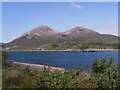
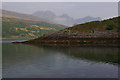
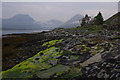
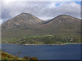
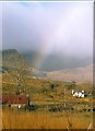
To the S of the township of Torran, on the summit of a long, elevated, rocky ridge rising from the E side of Loch Slappin, is Dun Mor. It stands about 100ft higher than the loch to the W, and about the same height above a hollow on the E, which cuts it off from the hills behind. The ridge is difficult of access except from the N, at which end is the entrance to the dun. The main axis of the fort runs N and S, along which it measures some 330ft internally, while it is some 120ft in breadth.
It has been defended by a massive stone wall, which far the greater part has been demolished to provide building material for a very large cattle-fold erected within its boundaries. So complete has been the destruction of this wall, that while it can be traced for nearly its entire length, only at the S end, on the SE arc and at the N end is any of the original building in position. A few of the larger foundation stones on the outer face of the wall remain undisturbed at the S end, and a short section of building to the SE has been preserved by being utilized as the foundation of the modern wall at this part. At the N end is a mass of tumbled stones 10ft in breadth and 3ft in height. The entrance is quite obliterated.
Source: Canmore
You may be viewing yesterday's version of this page. To see the most up to date information please register for a free account.
 (PID:166238)")
 (PID:166236)")
 (PID:166235)")
 (PID:166234)")
Do not use the above information on other web sites or publications without permission of the contributor.
Nearby Images from Geograph Britain and Ireland:
©2010(licence)
©2014(licence)
©2014(licence)
©2008(licence)
©2006(licence)
The above images may not be of the site on this page, they are loaded from Geograph.
Please Submit an Image of this site or go out and take one for us!
Click here to see more info for this site
Nearby sites
Key: Red: member's photo, Blue: 3rd party photo, Yellow: other image, Green: no photo - please go there and take one, Grey: site destroyed
Download sites to:
KML (Google Earth)
GPX (GPS waypoints)
CSV (Garmin/Navman)
CSV (Excel)
To unlock full downloads you need to sign up as a Contributory Member. Otherwise downloads are limited to 50 sites.
Turn off the page maps and other distractions
Nearby sites listing. In the following links * = Image available
328m SSE 157° Dun Beag (Loch Slapin)* Stone Fort or Dun (NG57511984)
1.6km E 81° Clach na h'Annait* Standing Stone (Menhir) (NG58952029)
2.1km E 99° High Pasture Cave* Cave or Rock Shelter (NG59431971)
2.8km WSW 254° Abhainn Cille Mhaire Standing Stones (NG54611952)
3.4km SSW 199° Dun Ringill* Broch or Nuraghe (NG561170)
3.4km SE 137° Dun Kearstack* Hillfort (NG596175)
3.4km SW 231° Kilmarie Standing Stones (NG54591814)
3.5km SW 214° Cnocan nan Gobhar* Round Cairn (NG55261735)
3.7km SSW 213° Kilmarie (Strathaird) Stone Circle (NG552172)
3.9km SW 228° Na Clachan Bhreige* Stone Circle (NG5433817681)
4.4km SSW 205° Cadha nan Ingrean* Stone Fort or Dun (NG55331625)
4.6km E 85° Kilchrist, Glebe* Stone Circle (NG61972027)
4.7km NE 56° Buaile Nan Aodan Standing Stones (NG61452255)
5.4km SSW 207° An Reidhean* Stone Circle (NG54701548)
5.6km ENE 67° Suardal* Chambered Cairn (NG62722203)
5.7km SE 131° Dun Boreraig Fort* Hillfort (NG615162)
5.9km SE 126° Dun Boreraig Stone* Standing Stone (Menhir) (NG61951638)
6.6km SSW 204° Dun Liath (Elgol)* Broch or Nuraghe (NG54331427)
6.8km SSW 211° Allt Na Cille Standing Stone (Menhir) (NG53501453)
7.0km SSW 207° Allt Na Cille Souterrain (Fogou, Earth House) (NG539141)
7.6km ENE 58° Corry chambered cairn* Chambered Cairn (NG6416023780)
7.8km NE 55° Corry cist, cairn and souterrain Cist (NG641242)
7.9km SW 220° Raven's Stone (Elgol) Standing Stone (Menhir) (NG520144)
8.0km ESE 103° Heaste Stone Standing Stone (Menhir) (NG6505117847)
8.0km SE 144° Tobar Chaon* Holy Well or Sacred Spring (NG61711340)
View more nearby sites and additional images


 We would like to know more about this location. Please feel free to add a brief description and any relevant information in your own language.
 Wir möchten mehr über diese Stätte erfahren. Bitte zögern Sie nicht, eine kurze Beschreibung und relevante Informationen in Deutsch hinzuzufügen.
 Nous aimerions en savoir encore un peu sur les lieux. S'il vous plaît n'hesitez pas à ajouter une courte description et tous les renseignements pertinents dans votre propre langue.
 Quisieramos informarnos un poco más de las lugares. No dude en añadir una breve descripción y otros datos relevantes en su propio idioma.