

<< Our Photo Pages >> Castro do Azougada - Ancient Village or Settlement in Portugal in Beja
Submitted by Maatje on Tuesday, 08 February 2022 Page Views: 448
Multi-periodSite Name: Castro do Azougada Alternative Name: Settlement at Ardila RiverCountry: Portugal Distrito: Beja Type: Ancient Village or Settlement
Nearest Town: Moura
Latitude: 38.172830N Longitude: 7.465688W
Condition:
| 5 | Perfect |
| 4 | Almost Perfect |
| 3 | Reasonable but with some damage |
| 2 | Ruined but still recognisable as an ancient site |
| 1 | Pretty much destroyed, possibly visible as crop marks |
| 0 | No data. |
| -1 | Completely destroyed |
| 5 | Superb |
| 4 | Good |
| 3 | Ordinary |
| 2 | Not Good |
| 1 | Awful |
| 0 | No data. |
| 5 | Can be driven to, probably with disabled access |
| 4 | Short walk on a footpath |
| 3 | Requiring a bit more of a walk |
| 2 | A long walk |
| 1 | In the middle of nowhere, a nightmare to find |
| 0 | No data. |
| 5 | co-ordinates taken by GPS or official recorded co-ordinates |
| 4 | co-ordinates scaled from a detailed map |
| 3 | co-ordinates scaled from a bad map |
| 2 | co-ordinates of the nearest village |
| 1 | co-ordinates of the nearest town |
| 0 | no data |
Internal Links:
External Links:
")
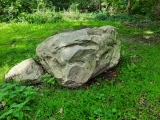
It is situated on private land but you can go in. The site has some signs of excavation but there is no information. You can image ancient people settled there: safe to be protected from high water, very fertile earth, and a broad view over both sides of the river. Most probably is was inhabited in the iron age and later. From the hill you can see Moura.
You may be viewing yesterday's version of this page. To see the most up to date information please register for a free account.
")
")
Do not use the above information on other web sites or publications without permission of the contributor.
Nearby Images from Flickr
The above images may not be of the site on this page, but were taken nearby. They are loaded from Flickr so please click on them for image credits.
Click here to see more info for this site
Nearby sites
Click here to view sites on an interactive map of the areaKey: Red: member's photo, Blue: 3rd party photo, Yellow: other image, Green: no photo - please go there and take one, Grey: site destroyed
Download sites to:
KML (Google Earth)
GPX (GPS waypoints)
CSV (Garmin/Navman)
CSV (Excel)
To unlock full downloads you need to sign up as a Contributory Member. Otherwise downloads are limited to 50 sites.
Turn off the page maps and other distractions
Nearby sites listing. In the following links * = Image available
3.1km NW 322° Castro dos Ratinhos* Castro or Chafurdão
3.5km SSE 156° Castro da Azougada Castro or Chafurdão
3.6km SSE 163° Museu de Moura Arqueologia* Museum
8.3km W 279° Anta Grande de Corte Serrão* Burial Chamber or Dolmen
8.3km W 280° Anta Pequena de Corte Serrão* Burial Chamber or Dolmen
11.3km NNW 338° Anta da Torrejona 2* Burial Chamber or Dolmen
11.4km NNW 338° Anta da Torrejona 1* Burial Chamber or Dolmen
15.8km NW 325° Anta do Chão da Pereira* Burial Chamber or Dolmen
20.4km NNE 21° Museu da Luz* Museum
24.0km NNW 348° Farisoa* Stone Circle
25.1km N 349° Menir na Herdade das Vidigueiras* Standing Stone (Menhir)
25.5km N 356° Anta das Areias 2* Burial Chamber or Dolmen
25.5km N 356° Anta das Areias 1* Burial Chamber or Dolmen
25.6km N 351° Menir dos Gorginos* Standing Stone (Menhir)
25.9km NW 307° Antas da Herdade do Freixo* Burial Chamber or Dolmen
27.7km SSW 192° Barragem Romana do Muro dos Mouros* Misc. Earthwork
27.9km SSW 204° Museu Arqueológico Castle of Serpa* Museum
28.1km NW 308° Castro de Castelo Velho Castro or Chafurdão
28.8km SSW 194° Roman Olive Oil Press* Sculptured Stone
30.3km N 9° Menir do Barrocal* Standing Stone (Menhir)
30.3km N 358° Rocha dos Namorados* Standing Stone (Menhir)
30.4km N 353° Cromeleque do Monte da Ribeira do Álamo* Stone Circle
30.5km NNW 347° Menires na Herdade dos Perdigões* Stone Circle
30.8km NNE 19° Praia Fluvial de Monsaraz Modern Stone Circle* Modern Stone Circle etc
31.0km N 6° Menir de Santa Margarida* Standing Stone (Menhir)
View more nearby sites and additional images


 We would like to know more about this location. Please feel free to add a brief description and any relevant information in your own language.
 Wir möchten mehr über diese Stätte erfahren. Bitte zögern Sie nicht, eine kurze Beschreibung und relevante Informationen in Deutsch hinzuzufügen.
 Nous aimerions en savoir encore un peu sur les lieux. S'il vous plaît n'hesitez pas à ajouter une courte description et tous les renseignements pertinents dans votre propre langue.
 Quisieramos informarnos un poco más de las lugares. No dude en añadir una breve descripción y otros datos relevantes en su propio idioma.