


<< Our Photo Pages >> Museu da Luz - Museum in Portugal in Évora
Submitted by Maatje on Sunday, 13 February 2022 Page Views: 444
MuseumsSite Name: Museu da LuzCountry: Portugal Distrito: Évora Type: Museum
Nearest Town: Mourão Nearest Village: Luz
Latitude: 38.344184N Longitude: 7.381597W
Condition:
| 5 | Perfect |
| 4 | Almost Perfect |
| 3 | Reasonable but with some damage |
| 2 | Ruined but still recognisable as an ancient site |
| 1 | Pretty much destroyed, possibly visible as crop marks |
| 0 | No data. |
| -1 | Completely destroyed |
| 5 | Superb |
| 4 | Good |
| 3 | Ordinary |
| 2 | Not Good |
| 1 | Awful |
| 0 | No data. |
| 5 | Can be driven to, probably with disabled access |
| 4 | Short walk on a footpath |
| 3 | Requiring a bit more of a walk |
| 2 | A long walk |
| 1 | In the middle of nowhere, a nightmare to find |
| 0 | No data. |
| 5 | co-ordinates taken by GPS or official recorded co-ordinates |
| 4 | co-ordinates scaled from a detailed map |
| 3 | co-ordinates scaled from a bad map |
| 2 | co-ordinates of the nearest village |
| 1 | co-ordinates of the nearest town |
| 0 | no data |
Internal Links:
External Links:
")
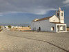
This brand new Museum of Luz was build when the Alqueva Reservoir was installed in 2002. A beautiful building, made of schist and completely integrated in the landscape.
This large water reservoir is part of the Guadiana River and has to supply water to the agriculture of the very dry East-Alentejo region.
1. The village of Luz was offered to this Reservoir. They have rebuilt a new village at the another hilltop, and they replaced the church and cemetery.
2. The Castelo da Lousa was also submerged to the Alqueva Reservoir.
This Castelo da Lousa was first excavated and in the museum you can see the Roman remains found there. The Castelo da Lousa was packed in concrete as a time capsule before it disappeared under water in the new Barragem of Alqueva.
The museum shows documentaries about both processes. One of Castelo da Lousa being excavated and packed and a touching documentary how the people in the old village of Luz had to leave their homes and land and move to the newly built village.
You may be viewing yesterday's version of this page. To see the most up to date information please register for a free account.
")
")
Do not use the above information on other web sites or publications without permission of the contributor.
Nearby Images from Flickr


The above images may not be of the site on this page, but were taken nearby. They are loaded from Flickr so please click on them for image credits.
Click here to see more info for this site
Nearby sites
Click here to view sites on an interactive map of the areaKey: Red: member's photo, Blue: 3rd party photo, Yellow: other image, Green: no photo - please go there and take one, Grey: site destroyed
Download sites to:
KML (Google Earth)
GPX (GPS waypoints)
CSV (Garmin/Navman)
CSV (Excel)
To unlock full downloads you need to sign up as a Contributory Member. Otherwise downloads are limited to 50 sites.
Turn off the page maps and other distractions
Nearby sites listing. In the following links * = Image available
10.4km NNE 15° Praia Fluvial de Monsaraz Modern Stone Circle* Modern Stone Circle etc
11.0km NW 306° Anta das Areias 1* Burial Chamber or Dolmen
11.0km NW 306° Anta das Areias 2* Burial Chamber or Dolmen
11.2km NNW 346° Menir do Barrocal* Standing Stone (Menhir)
12.0km N 352° Anta 1 do Olival da Pega* Burial Chamber or Dolmen
12.0km N 353° Anta 2 do Olival da Pega* Burial Chamber or Dolmen
12.1km N 0° Well of Telheiro* Holy Well or Sacred Spring
12.2km N 4° Cromeleque do Xarez* Stone Circle
12.6km NNW 340° Menir de Santa Margarida* Standing Stone (Menhir)
12.8km WNW 299° Menir dos Gorginos* Standing Stone (Menhir)
12.8km N 360° Anta da Belhôa* Burial Chamber or Dolmen
13.0km WNW 290° Farisoa* Stone Circle
13.1km N 360° Menir da Bulhoa* Standing Stone (Menhir)
13.3km WNW 295° Menir na Herdade das Vidigueiras* Standing Stone (Menhir)
13.9km NW 324° Rocha dos Namorados* Standing Stone (Menhir)
14.1km N 356° Menhir de Outeiro* Standing Stone (Menhir)
14.4km SW 233° Anta da Torrejona 2* Burial Chamber or Dolmen
14.4km SW 234° Anta da Torrejona 1* Burial Chamber or Dolmen
15.6km NW 315° Cromeleque do Monte da Ribeira do Álamo* Stone Circle
17.6km WSW 249° Anta do Chão da Pereira* Burial Chamber or Dolmen
17.7km NW 307° Menires na Herdade dos Perdigões* Stone Circle
19.0km SSW 209° Castro dos Ratinhos* Castro or Chafurdão
20.4km SSW 201° Castro do Azougada* Ancient Village or Settlement
23.0km SSW 195° Castro da Azougada Castro or Chafurdão
23.4km SSW 196° Museu de Moura Arqueologia* Museum
View more nearby sites and additional images


 We would like to know more about this location. Please feel free to add a brief description and any relevant information in your own language.
 Wir möchten mehr über diese Stätte erfahren. Bitte zögern Sie nicht, eine kurze Beschreibung und relevante Informationen in Deutsch hinzuzufügen.
 Nous aimerions en savoir encore un peu sur les lieux. S'il vous plaît n'hesitez pas à ajouter une courte description et tous les renseignements pertinents dans votre propre langue.
 Quisieramos informarnos un poco más de las lugares. No dude en añadir una breve descripción y otros datos relevantes en su propio idioma.