<< Our Photo Pages >> Tveit Standing Stone - Standing Stone (Menhir) in Norway in Rogaland
Submitted by kenntha88 on Sunday, 23 September 2012 Page Views: 1581
Neolithic and Bronze AgeSite Name: Tveit Standing StoneCountry: Norway
NOTE: This site is 20.683 km away from the location you searched for.
Fylke: Rogaland Type: Standing Stone (Menhir)
Latitude: 59.128369N Longitude: 6.250448E
Condition:
| 5 | Perfect |
| 4 | Almost Perfect |
| 3 | Reasonable but with some damage |
| 2 | Ruined but still recognisable as an ancient site |
| 1 | Pretty much destroyed, possibly visible as crop marks |
| 0 | No data. |
| -1 | Completely destroyed |
| 5 | Superb |
| 4 | Good |
| 3 | Ordinary |
| 2 | Not Good |
| 1 | Awful |
| 0 | No data. |
| 5 | Can be driven to, probably with disabled access |
| 4 | Short walk on a footpath |
| 3 | Requiring a bit more of a walk |
| 2 | A long walk |
| 1 | In the middle of nowhere, a nightmare to find |
| 0 | No data. |
| 5 | co-ordinates taken by GPS or official recorded co-ordinates |
| 4 | co-ordinates scaled from a detailed map |
| 3 | co-ordinates scaled from a bad map |
| 2 | co-ordinates of the nearest village |
| 1 | co-ordinates of the nearest town |
| 0 | no data |
Internal Links:
External Links:
")
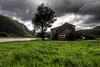
High up in a hillside overlooking the Årdal village, just 2 metres away from the road is this weather-beaten and rugged standing stone. The site has a beautiful view over the valley below!
The stone has a rugged surface, it is around 1.70 metres high, around 50cm wide and it is slightly slimmer at the base. Around the stone is smaller brush and some larger leaf trees.
You may be viewing yesterday's version of this page. To see the most up to date information please register for a free account.
")
")
")
Do not use the above information on other web sites or publications without permission of the contributor.
Nearby Images from Flickr


The above images may not be of the site on this page, but were taken nearby. They are loaded from Flickr so please click on them for image credits.
Click here to see more info for this site
Nearby sites
Click here to view sites on an interactive map of the areaKey: Red: member's photo, Blue: 3rd party photo, Yellow: other image, Green: no photo - please go there and take one, Grey: site destroyed
Download sites to:
KML (Google Earth)
GPX (GPS waypoints)
CSV (Garmin/Navman)
CSV (Excel)
To unlock full downloads you need to sign up as a Contributory Member. Otherwise downloads are limited to 50 sites.
Turn off the page maps and other distractions
Nearby sites listing. In the following links * = Image available
5.1km WNW 297° Øvre Mæle barrow cemetery* Barrow Cemetery
9.3km NW 307° Store Bjelland* Standing Stone (Menhir)
11.5km WNW 298° Midtre Fister* Barrow Cemetery
17.0km W 262° Kjølevik Runestone* Carving
19.8km WSW 246° Løbrekk av Strand settlement* Ancient Village or Settlement
19.9km SW 235° Nag standing stone* Standing Stone (Menhir)
20.1km SW 234° Nagavika* Standing Stone (Menhir)
20.1km WSW 248° Tau-Åna stone age settlement* Ancient Village or Settlement
20.4km WSW 245° Strand Barrow Mounds* Round Barrow(s)
20.6km WSW 244° Solbakk* Rock Art
23.5km W 264° Kjørkjehauen* Standing Stone (Menhir)
26.1km SSW 203° Kjødlingevollen* Ancient Village or Settlement
29.6km WSW 251° Pigghedlene* Standing Stones
30.1km WSW 251° Austre Åmøy* Rock Art
30.5km WSW 251° Meling Austre Åmøy* Rock Art
31.6km W 264° Vikevåg* Barrow Cemetery
32.9km W 260° Hedlehaugen* Standing Stones
32.9km WSW 257° Askje Hedlehaug* Standing Stone (Menhir)
33.2km WSW 253° Varaberg* Standing Stone (Menhir)
33.4km WSW 245° Stavangerfjords Vei* Standing Stone (Menhir)
33.4km WSW 253° Hegrebergveien Pigghedlane* Standing Stones
33.4km W 260° Vaula Settlement* Ancient Village or Settlement
33.4km WSW 253° Hegreberg* Standing Stone (Menhir)
34.3km W 262° Mosterøyvegen Standing Stone* Standing Stone (Menhir)
34.4km S 185° Frøyland-Dirdal* Ancient Village or Settlement
View more nearby sites and additional images


 We would like to know more about this location. Please feel free to add a brief description and any relevant information in your own language.
 Wir möchten mehr über diese Stätte erfahren. Bitte zögern Sie nicht, eine kurze Beschreibung und relevante Informationen in Deutsch hinzuzufügen.
 Nous aimerions en savoir encore un peu sur les lieux. S'il vous plaît n'hesitez pas à ajouter une courte description et tous les renseignements pertinents dans votre propre langue.
 Quisieramos informarnos un poco más de las lugares. No dude en añadir una breve descripción y otros datos relevantes en su propio idioma.