

<< Our Photo Pages >> Kjølevik Runestone - Carving in Norway in Rogaland
Submitted by kenntha88 on Monday, 20 August 2012 Page Views: 2808
Early Medieval (Dark Age)Site Name: Kjølevik RunestoneCountry: Norway Fylke: Rogaland Type: Carving
Nearest Town: Stavanger Nearest Village: Tau
Latitude: 59.106543N Longitude: 5.955985E
Condition:
| 5 | Perfect |
| 4 | Almost Perfect |
| 3 | Reasonable but with some damage |
| 2 | Ruined but still recognisable as an ancient site |
| 1 | Pretty much destroyed, possibly visible as crop marks |
| 0 | No data. |
| -1 | Completely destroyed |
| 5 | Superb |
| 4 | Good |
| 3 | Ordinary |
| 2 | Not Good |
| 1 | Awful |
| 0 | No data. |
| 5 | Can be driven to, probably with disabled access |
| 4 | Short walk on a footpath |
| 3 | Requiring a bit more of a walk |
| 2 | A long walk |
| 1 | In the middle of nowhere, a nightmare to find |
| 0 | No data. |
| 5 | co-ordinates taken by GPS or official recorded co-ordinates |
| 4 | co-ordinates scaled from a detailed map |
| 3 | co-ordinates scaled from a bad map |
| 2 | co-ordinates of the nearest village |
| 1 | co-ordinates of the nearest town |
| 0 | no data |
Internal Links:
External Links:
")
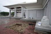
The Kjølevik runestone is one of the most important runestone with older norse runes found in Norway, it is beautifully preserved and the runic inscription is one of the longest found in Norway in older runes. The original stone was moved to the university ancient collection museum in Oslo, In 1982, a copy was placed close to the original site.
A copy of the Kjølevik stone was made by Kåre Tveit and unveiled in 1982 at Kjølevik, Strand in Ryfylke. The original was found 100 years earlier in the ceiling of a potato cellar in Kjølevik by a local farmer. A year later, this original stone was moved to the collection of the University of Oslo, where it is now exhibited. The inscription of Old Norse runes probably dates back to the time of migrations in 400-450 AD.
The runic inscription has been translated as follow: "Hagulaik lies buried here, I Hagustaldr buried my son."
Even though no grave was found near the stone, it is probably a grave marker stone because of the runic text.
You may be viewing yesterday's version of this page. To see the most up to date information please register for a free account.
")
")
")
")
")
")
Do not use the above information on other web sites or publications without permission of the contributor.
Click here to see more info for this site
Nearby sites
Click here to view sites on an interactive map of the areaKey: Red: member's photo, Blue: 3rd party photo, Yellow: other image, Green: no photo - please go there and take one, Grey: site destroyed
Download sites to:
KML (Google Earth)
GPX (GPS waypoints)
CSV (Garmin/Navman)
CSV (Excel)
To unlock full downloads you need to sign up as a Contributory Member. Otherwise downloads are limited to 50 sites.
Turn off the page maps and other distractions
Nearby sites listing. In the following links * = Image available
5.4km SSW 200° Tau-Åna stone age settlement* Ancient Village or Settlement
5.7km SSW 193° Løbrekk av Strand settlement* Ancient Village or Settlement
6.5km SSW 194° Strand Barrow Mounds* Round Barrow(s)
6.5km W 270° Kjørkjehauen* Standing Stone (Menhir)
6.8km SSW 194° Solbakk* Rock Art
9.1km S 176° Nag standing stone* Standing Stone (Menhir)
9.3km S 177° Nagavika* Standing Stone (Menhir)
10.2km NE 41° Midtre Fister* Barrow Cemetery
12.3km NE 49° Store Bjelland* Standing Stone (Menhir)
13.1km ENE 69° Øvre Mæle barrow cemetery* Barrow Cemetery
13.3km WSW 238° Pigghedlene* Standing Stones
13.8km WSW 237° Austre Åmøy* Rock Art
14.2km WSW 237° Meling Austre Åmøy* Rock Art
14.7km W 267° Vikevåg* Barrow Cemetery
15.9km WSW 257° Hedlehaugen* Standing Stones
16.0km WSW 252° Askje Hedlehaug* Standing Stone (Menhir)
16.4km WSW 259° Vaula Settlement* Ancient Village or Settlement
16.7km WSW 243° Varaberg* Standing Stone (Menhir)
16.8km WSW 244° Hegrebergveien Pigghedlane* Standing Stones
16.8km WSW 244° Hegreberg* Standing Stone (Menhir)
17.0km E 82° Tveit Standing Stone* Standing Stone (Menhir)
17.3km W 262° Mosterøyvegen Standing Stone* Standing Stone (Menhir)
17.9km SW 228° Stavangerfjords Vei* Standing Stone (Menhir)
18.0km W 278° Sørbø Runestone* Carving
18.0km W 277° Austhaugstyttå* Standing Stone (Menhir)
View more nearby sites and additional images


 We would like to know more about this location. Please feel free to add a brief description and any relevant information in your own language.
 Wir möchten mehr über diese Stätte erfahren. Bitte zögern Sie nicht, eine kurze Beschreibung und relevante Informationen in Deutsch hinzuzufügen.
 Nous aimerions en savoir encore un peu sur les lieux. S'il vous plaît n'hesitez pas à ajouter une courte description et tous les renseignements pertinents dans votre propre langue.
 Quisieramos informarnos un poco más de las lugares. No dude en añadir una breve descripción y otros datos relevantes en su propio idioma.