

<< Our Photo Pages >> Manchester Ship Canal Stone - Marker Stone in England in Cheshire
Submitted by MaccMan on Wednesday, 21 May 2025 Page Views: 2116
Modern SitesSite Name: Manchester Ship Canal StoneCountry: England
NOTE: This site is 1.0 km away from the location you searched for.
County: Cheshire Type: Marker Stone
Nearest Town: Wilmslow
Map Ref: SJ83898193
Latitude: 53.334030N Longitude: 2.243379W
Condition:
| 5 | Perfect |
| 4 | Almost Perfect |
| 3 | Reasonable but with some damage |
| 2 | Ruined but still recognisable as an ancient site |
| 1 | Pretty much destroyed, possibly visible as crop marks |
| 0 | No data. |
| -1 | Completely destroyed |
| 5 | Superb |
| 4 | Good |
| 3 | Ordinary |
| 2 | Not Good |
| 1 | Awful |
| 0 | No data. |
| 5 | Can be driven to, probably with disabled access |
| 4 | Short walk on a footpath |
| 3 | Requiring a bit more of a walk |
| 2 | A long walk |
| 1 | In the middle of nowhere, a nightmare to find |
| 0 | No data. |
| 5 | co-ordinates taken by GPS or official recorded co-ordinates |
| 4 | co-ordinates scaled from a detailed map |
| 3 | co-ordinates scaled from a bad map |
| 2 | co-ordinates of the nearest village |
| 1 | co-ordinates of the nearest town |
| 0 | no data |
Internal Links:
External Links:
")
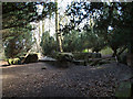
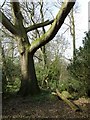
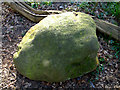
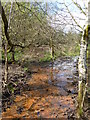
The stone is close to the ruins of the private chapel originally belonging to Pownall Hall. It is the high wooded footpath at The Carrs in Wilmslow. I must have walked passed this spot a hundred times without noticing it, so if you find the ruins the stone is nearby.
You may be viewing yesterday's version of this page. To see the most up to date information please register for a free account.
")
")
Do not use the above information on other web sites or publications without permission of the contributor.
Nearby Images from Geograph Britain and Ireland:
©2010(licence)
©2010(licence)
©2010(licence)
©2005(licence)
©2015(licence)
The above images may not be of the site on this page, they are loaded from Geograph.
Please Submit an Image of this site or go out and take one for us!
Click here to see more info for this site
Nearby sites
Key: Red: member's photo, Blue: 3rd party photo, Yellow: other image, Green: no photo - please go there and take one, Grey: site destroyed
Download sites to:
KML (Google Earth)
GPX (GPS waypoints)
CSV (Garmin/Navman)
CSV (Excel)
To unlock full downloads you need to sign up as a Contributory Member. Otherwise downloads are limited to 50 sites.
Turn off the page maps and other distractions
Nearby sites listing. In the following links * = Image available
3.5km SW 236° Lindow* Ancient Trackway (SJ810800)
4.4km SSE 151° Findlow Marker Stone (SJ86027808)
4.5km SSE 154° Holy Well (Alderley Edge)* Holy Well or Sacred Spring (SJ85907786)
4.5km SSE 155° Wizard's Well* Holy Well or Sacred Spring (SJ858778)
4.6km SSE 152° Druidical Circle* Modern Stone Circle etc (SJ86077788)
4.6km SSE 156° Armada Beacon* Round Barrow(s) (SJ858777)
4.7km SSE 152° Wizard's Cave Cave or Rock Shelter (SJ86087782)
4.7km SSE 153° Wishing Well (Alderley Edge)* Holy Well or Sacred Spring (SJ860777)
4.9km SSE 153° Engine Vein, Alderley Edge Copper Mines* Ancient Mine, Quarry or other Industry (SJ861776)
4.9km SSE 153° Golden Stone (Alderley Edge)* Standing Stone (Menhir) (SJ861776)
5.0km SE 135° Mottram St Andrew Mines Ancient Mine, Quarry or other Industry (SJ874784)
5.6km SSE 156° Great Merestone Marker Stone (SJ86137677)
6.6km ESE 110° Adlington Hall pre-Norman cross* Ancient Cross (SJ901797)
6.9km NNE 15° St Mary (Cheadle, Stockport) Ancient Cross (SJ85668864)
7.6km SSE 167° Birtles Hall Round Barrow(s) (SJ856745)
7.7km ESE 118° Bonis Hall Lane* Round Barrow(s) (SJ907783)
7.7km ESE 118° Butley Barrow* Round Barrow(s) (SJ9072278334)
8.0km SE 129° St Peter (Prestbury)* Ancient Cross (SJ9008676910)
8.0km S 178° Sodger's Hump* Round Barrow(s) (SJ842739)
8.1km ESE 119° Butley Stone Circle (SJ9178)
8.2km W 267° Tatton Iron Age roundhouse and pit* Ancient Village or Settlement (SJ757815)
8.2km W 266° Tatton Neolithic posthole and pit* Ancient Village or Settlement (SJ757814)
8.5km W 264° Tatton Neolithic hearth* Ancient Village or Settlement (SJ754811)
8.6km SSW 199° Astle Park Round Barrow(s) (SJ811738)
8.9km S 180° Capesthorne Hall (NW) Round Barrow(s) (SJ838730)
View more nearby sites and additional images


 We would like to know more about this location. Please feel free to add a brief description and any relevant information in your own language.
 Wir möchten mehr über diese Stätte erfahren. Bitte zögern Sie nicht, eine kurze Beschreibung und relevante Informationen in Deutsch hinzuzufügen.
 Nous aimerions en savoir encore un peu sur les lieux. S'il vous plaît n'hesitez pas à ajouter une courte description et tous les renseignements pertinents dans votre propre langue.
 Quisieramos informarnos un poco más de las lugares. No dude en añadir una breve descripción y otros datos relevantes en su propio idioma.