 with our Megalithic Portal iPhone app")


<< Our Photo Pages >> Curbar Edge Barrow - Cairn in England in Derbyshire
Submitted by AndyS99 on Saturday, 26 July 2025 Page Views: 518
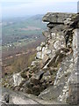
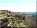
Neolithic and Bronze AgeSite Name: Curbar Edge BarrowCountry: England
NOTE: This site is 0.98 km away from the location you searched for.
County: Derbyshire Type: Cairn
Nearest Village: Curbar
Map Ref: SK25547555
Latitude: 53.276322N Longitude: 1.618454W
Condition:
| 5 | Perfect |
| 4 | Almost Perfect |
| 3 | Reasonable but with some damage |
| 2 | Ruined but still recognisable as an ancient site |
| 1 | Pretty much destroyed, possibly visible as crop marks |
| 0 | No data. |
| -1 | Completely destroyed |
| 5 | Superb |
| 4 | Good |
| 3 | Ordinary |
| 2 | Not Good |
| 1 | Awful |
| 0 | No data. |
| 5 | Can be driven to, probably with disabled access |
| 4 | Short walk on a footpath |
| 3 | Requiring a bit more of a walk |
| 2 | A long walk |
| 1 | In the middle of nowhere, a nightmare to find |
| 0 | No data. |
| 5 | co-ordinates taken by GPS or official recorded co-ordinates |
| 4 | co-ordinates scaled from a detailed map |
| 3 | co-ordinates scaled from a bad map |
| 2 | co-ordinates of the nearest village |
| 1 | co-ordinates of the nearest town |
| 0 | no data |
Internal Links:
External Links:
")
The mound was partially excavated in 1913 by the Duke of Rutland and his gamekeeper Mr Peat. They revealed a gritstone cist containing cremation remains, pottery fragments, a broken bronze knife, and a flint scraper. A little to the North are Bronze Age fields and enclosures, demarcated by low earthworks.
You may be viewing yesterday's version of this page. To see the most up to date information please register for a free account.
")
Do not use the above information on other web sites or publications without permission of the contributor.
Nearby Images from Geograph Britain and Ireland:

©2023(licence)
©2012(licence)

©2017(licence)

©2017(licence)
©2005(licence)
The above images may not be of the site on this page, they are loaded from Geograph.
Please Submit an Image of this site or go out and take one for us!
Click here to see more info for this site
Nearby sites
Key: Red: member's photo, Blue: 3rd party photo, Yellow: other image, Green: no photo - please go there and take one, Grey: site destroyed
Download sites to:
KML (Google Earth)
GPX (GPS waypoints)
CSV (Garmin/Navman)
CSV (Excel)
To unlock full downloads you need to sign up as a Contributory Member. Otherwise downloads are limited to 50 sites.
Turn off the page maps and other distractions
Nearby sites listing. In the following links * = Image available
1.4km NNW 335° Stoke Flat* Stone Circle (SK24967679)
1.5km ESE 104° Barbrook 5* Ring Cairn (SK270752)
1.7km ESE 109° Swine Sty* Ancient Village or Settlement (SK272750)
2.0km E 95° Big Moor* Ancient Village or Settlement (SK275754)
2.0km E 84° Big Moor Cairns SW* Barrow Cemetery (SK27587579)
2.1km E 89° Barbrook Cupmarked Stone* Standing Stone (Menhir) (SK27647560)
2.2km E 83° Barbrook 2* Stone Circle (SK27757582)
2.3km E 87° Big Moor Cairn Field* Barrow Cemetery (SK278757)
2.3km E 90° Barbrook 1* Stone Circle (SK27857558)
2.3km W 272° Stoney Middleton Thermal Springs* Holy Well or Sacred Spring (SK232756)
2.4km E 89° Barbrook cairn* Cairn (SK27917561)
2.4km NNE 32° White Edge Cairn* Cairn (SK26847762)
2.5km NNE 33° The Hurkling Stone* Marker Stone (SK269777)
2.8km S 175° Lady Well Wall* Holy Well or Sacred Spring (SK258728)
2.8km WNW 288° Riley Graves* Standing Stone (Menhir) (SK22867639)
2.9km SE 146° Gardoms Edge Enclosure* Causewayed Enclosure (SK2716473201)
2.9km SE 144° Gardoms Edge Stone* Standing Stone (Menhir) (SK2725273225)
2.9km SE 141° Gardoms Edge Cairns* Barrow Cemetery (SK27407330)
2.9km W 275° Eyam Boundary Stone* Marker Stone (SK226758)
3.0km SE 139° Gardoms Edge 02 (Baslow) Rock Art (SK27527328)
3.0km SE 137° Gardoms Edge 2 (Baslow)* Rock Art (SK2761773339)
3.1km SE 146° Gardoms Edge 1* Rock Art (SK2728573037)
3.2km WNW 293° Top Of Riley Stone Circle (SK226768)
3.2km SSE 150° Three Men of Gardoms* Round Barrow(s) (SK2716172774)
3.3km ENE 58° Barbrook 3* Stone Circle (SK28347729)
View more nearby sites and additional images


 We would like to know more about this location. Please feel free to add a brief description and any relevant information in your own language.
 Wir möchten mehr über diese Stätte erfahren. Bitte zögern Sie nicht, eine kurze Beschreibung und relevante Informationen in Deutsch hinzuzufügen.
 Nous aimerions en savoir encore un peu sur les lieux. S'il vous plaît n'hesitez pas à ajouter une courte description et tous les renseignements pertinents dans votre propre langue.
 Quisieramos informarnos un poco más de las lugares. No dude en añadir una breve descripción y otros datos relevantes en su propio idioma.