


<< Our Photo Pages >> Eyam Boundary Stone - Marker Stone in England in Derbyshire
Submitted by nicoladidsbury on Monday, 18 February 2008 Page Views: 20527
Multi-periodSite Name: Eyam Boundary StoneCountry: England County: Derbyshire Type: Marker Stone
Nearest Town: Bakewell Nearest Village: Eyam
Map Ref: SK226758
Latitude: 53.278701N Longitude: 1.662524W
Condition:
| 5 | Perfect |
| 4 | Almost Perfect |
| 3 | Reasonable but with some damage |
| 2 | Ruined but still recognisable as an ancient site |
| 1 | Pretty much destroyed, possibly visible as crop marks |
| 0 | No data. |
| -1 | Completely destroyed |
| 5 | Superb |
| 4 | Good |
| 3 | Ordinary |
| 2 | Not Good |
| 1 | Awful |
| 0 | No data. |
| 5 | Can be driven to, probably with disabled access |
| 4 | Short walk on a footpath |
| 3 | Requiring a bit more of a walk |
| 2 | A long walk |
| 1 | In the middle of nowhere, a nightmare to find |
| 0 | No data. |
| 5 | co-ordinates taken by GPS or official recorded co-ordinates |
| 4 | co-ordinates scaled from a detailed map |
| 3 | co-ordinates scaled from a bad map |
| 2 | co-ordinates of the nearest village |
| 1 | co-ordinates of the nearest town |
| 0 | no data |
Internal Links:
External Links:
I have visited· I would like to visit
stretchyboy visited on 1st Aug 2020 - their rating: Cond: 4 Amb: 4 Access: 3
nicoladidsbury have visited here
")
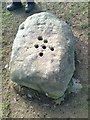
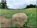
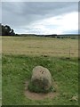
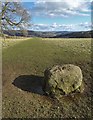
Eyam Boundary Stone
Eyam is famous for an event in 1665 and 1666, when a bolt of cloth was delivered to the tailor, which was thought to contain fleas infected with the black plague. The villagers decided to cut themselves and the village off from the rest of the area. Over a period of 14 months almost a third of the villagers died, but the plague did not spread.
A footpath leads out of the village, towards Stoney Middleton via the Boundary Stone. This stone was the place where residents of Eyam left money during the plague, in exchange for goods. The stone has six holes that were filled with vinegar to disinfect the money.
I think the stone may be very old, and wonder if the holes existed before the need for using them as little wells to disinfect money. Could they possibly be cup marks? Wild conjecture I know; I am however interested to know if anyone else has any views on its possible antiquity.
The surrounding grass land is marvellous, I recommend a visit during May when the field is full of wild flowers, in complete profusion.
You may be viewing yesterday's version of this page. To see the most up to date information please register for a free account.
Do not use the above information on other web sites or publications without permission of the contributor.
Nearby Images from Geograph Britain and Ireland:
©2019(licence)
©2023(licence)
©2010(licence)
©2017(licence)
©2018(licence)
The above images may not be of the site on this page, they are loaded from Geograph.
Please Submit an Image of this site or go out and take one for us!
Click here to see more info for this site
Nearby sites
Key: Red: member's photo, Blue: 3rd party photo, Yellow: other image, Green: no photo - please go there and take one, Grey: site destroyed
Download sites to:
KML (Google Earth)
GPX (GPS waypoints)
CSV (Garmin/Navman)
CSV (Excel)
To unlock full downloads you need to sign up as a Contributory Member. Otherwise downloads are limited to 50 sites.
Turn off the page maps and other distractions
Nearby sites listing. In the following links * = Image available
631m ESE 109° Stoney Middleton Thermal Springs* Holy Well or Sacred Spring (SK232756)
644m NNE 24° Riley Graves* Standing Stone (Menhir) (SK22867639)
998m NW 307° St Lawrence (Eyam)* Ancient Cross (SK218764)
1000m N 0° Top Of Riley Stone Circle (SK226768)
1.0km W 280° Eyam Delf* Cave or Rock Shelter (SK21577598)
1.3km SW 227° Poss. Stone circles/barrow, 615m SW of Highfields Farm Stone Circle (SK21617488)
1.4km NW 313° Eyam Museum* Museum (SK2159176729)
1.5km NNW 344° Mompesson's Well* Holy Well or Sacred Spring (SK222772)
2.6km ENE 67° Stoke Flat* Stone Circle (SK24967679)
2.9km SW 216° Longstone Edge barrows* Round Barrow(s) (SK20887341)
3.0km WSW 251° White Rake* Long Barrow (SK198748)
3.1km NNE 12° Eyam Moor III* Stone Circle (SK232788)
3.1km NNW 340° Stanage* Cairn (SK215787)
3.1km NW 319° Derwic Well* Holy Well or Sacred Spring (SK2054978171)
3.2km N 359° Wet Withens* Stone Circle (SK22557900)
3.2km N 359° Eyam Moor Barrow* Long Barrow (SK22547900)
3.3km N 11° Eyam Moor II* Stone Circle (SK232790)
4.4km SE 133° Lady Well Wall* Holy Well or Sacred Spring (SK258728)
4.4km E 98° Barbrook 5* Ring Cairn (SK270752)
4.4km NNW 346° Highlow Bank* Standing Stone (Menhir) (SK215801)
4.5km SW 236° Longstone Moor* Round Barrow(s) (SK18887328)
4.6km ENE 67° White Edge Cairn* Cairn (SK26847762)
4.7km E 100° Swine Sty* Ancient Village or Settlement (SK272750)
4.7km WSW 243° Rolley Low* Round Barrow(s) (SK18447362)
4.7km ENE 66° The Hurkling Stone* Marker Stone (SK269777)
View more nearby sites and additional images


 We would like to know more about this location. Please feel free to add a brief description and any relevant information in your own language.
 Wir möchten mehr über diese Stätte erfahren. Bitte zögern Sie nicht, eine kurze Beschreibung und relevante Informationen in Deutsch hinzuzufügen.
 Nous aimerions en savoir encore un peu sur les lieux. S'il vous plaît n'hesitez pas à ajouter une courte description et tous les renseignements pertinents dans votre propre langue.
 Quisieramos informarnos un poco más de las lugares. No dude en añadir una breve descripción y otros datos relevantes en su propio idioma.