


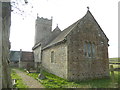
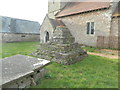
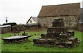
<< Our Photo Pages >> Llanfihangel Rogiet Churchyard Cross - Ancient Cross in Wales in Monmouthshire (Sir Fynwy)
Submitted by dooclay on Tuesday, 23 May 2023 Page Views: 815
Early MedievalSite Name: Llanfihangel Rogiet Churchyard CrossCountry: Wales County: Monmouthshire (Sir Fynwy) Type: Ancient Cross
Nearest Town: Newport Nearest Village: Llanfihangel Rogiet
Map Ref: ST4512087850
Latitude: 51.586818N Longitude: 2.793517W
Condition:
| 5 | Perfect |
| 4 | Almost Perfect |
| 3 | Reasonable but with some damage |
| 2 | Ruined but still recognisable as an ancient site |
| 1 | Pretty much destroyed, possibly visible as crop marks |
| 0 | No data. |
| -1 | Completely destroyed |
| 5 | Superb |
| 4 | Good |
| 3 | Ordinary |
| 2 | Not Good |
| 1 | Awful |
| 0 | No data. |
| 5 | Can be driven to, probably with disabled access |
| 4 | Short walk on a footpath |
| 3 | Requiring a bit more of a walk |
| 2 | A long walk |
| 1 | In the middle of nowhere, a nightmare to find |
| 0 | No data. |
| 5 | co-ordinates taken by GPS or official recorded co-ordinates |
| 4 | co-ordinates scaled from a detailed map |
| 3 | co-ordinates scaled from a bad map |
| 2 | co-ordinates of the nearest village |
| 1 | co-ordinates of the nearest town |
| 0 | no data |
Internal Links:
External Links:
")
From Coflein: A three-step cross base, 3.8m square and 1.3m high, bears a socket stone, part of which had been built in the church fabric. Restored 1904.
You may be viewing yesterday's version of this page. To see the most up to date information please register for a free account.
Do not use the above information on other web sites or publications without permission of the contributor.
Nearby Images from Geograph Britain and Ireland:
©2015(licence)
©2015(licence)
©2016(licence)

©2025(licence)

©2025(licence)
The above images may not be of the site on this page, they are loaded from Geograph.
Please Submit an Image of this site or go out and take one for us!
Nearby Images from Flickr


The above images may not be of the site on this page, but were taken nearby. They are loaded from Flickr so please click on them for image credits.
Nearby sites
Key: Red: member's photo, Blue: 3rd party photo, Yellow: other image, Green: no photo - please go there and take one, Grey: site destroyed
Download sites to:
KML (Google Earth)
GPX (GPS waypoints)
CSV (Garmin/Navman)
CSV (Excel)
To unlock full downloads you need to sign up as a Contributory Member. Otherwise downloads are limited to 50 sites.
Turn off the page maps and other distractions
Nearby sites listing. In the following links * = Image available
616m W 260° Llanfihangel Rogiet* Standing Stone (Menhir) (ST44518775)
1.2km WSW 241° Undy Earthwork Misc. Earthwork (ST441873)
2.3km NNW 342° Woodcock Hill Barrow Round Barrow(s) (ST44449008)
2.7km N 5° Middle Hendre Round Barrow(s) (ST454905)
2.8km S 188° Chapel Tump Ancient Village or Settlement (ST447851)
2.8km NW 319° The Larches Camp* Hillfort (ST433900)
2.9km S 190° Upton Ancient Trackway Ancient Trackway (ST446850)
3.1km N 357° Five Lanes Round Barrow (B) Round Barrow(s) (ST45019090)
3.1km N 357° Five Lanes Round Barrow (A) Round Barrow(s) (ST45019091)
3.1km NW 323° Carrow Hill Round Barrow Round Barrow(s) (ST43309035)
3.2km NNE 33° Silurum Stone* Marker Stone (ST46879049)
3.2km NW 318° Carrow Hill Round Barrow Pair Round Barrow(s) (ST42999029)
3.3km NNE 33° Venta Silurum Settlement* Ancient Village or Settlement (ST46959056)
3.3km NNE 33° Cult Temple at Venta Silurum* Ancient Temple (ST4695890564)
3.8km ESE 109° Caldicot Castle* Ancient Trackway (ST487866)
4.0km W 267° Wilcrick Hill Fort* Hillfort (ST411877)
4.1km NE 53° Crick Round Barrow* Round Barrow(s) (ST48449025)
4.1km W 272° Wilcrick Wishing Well* Holy Well or Sacred Spring (ST4097088044)
4.3km SSW 208° Caldicot Level Ancient Trackway (ST431841)
4.5km E 99° Caldicot Pill Submerged Forest Natural Stone / Erratic / Other Natural Feature (ST4956687114)
4.8km E 86° Portskewett Chutchyard Cross* Ancient Cross (ST4990088140)
4.8km N 11° Llanmelin Wood* Hillfort (ST46109260)
5.1km NNE 13° Llan-melin wood Earthwork Misc. Earthwork (ST463928)
5.2km ENE 59° Mathern Round Barrow(s) (ST496905)
5.4km E 95° Sudbrook Camp* Hillfort (ST50548731)
5.4km E 81° Heston Brake* Chambered Tomb (ST50528866)
5.5km NNW 349° Gray Hill Cairn Cemetery* Barrow Cemetery (ST4408693273)
5.8km NNW 346° Gray Hill circle* Stone Circle (ST43809353)
5.9km NNW 346° Gray Hill stone row* Standing Stone (Menhir) (ST43769357)
6.0km NNW 343° Gray Hill summit cairn* Round Cairn (ST43399355)
6.1km NE 43° NOT SET
6.1km NW 317° Castell Prin* Hillfort (ST410924)
6.6km NNW 340° Forresters' Oaks Round Barrow* Round Barrow(s) (ST42929410)
6.9km NE 51° Willis Hill Ancient Village or Settlement (ST50519216)
7.0km W 280° Langstone (Bishton)* Round Barrow(s) (ST382891)
7.2km WNW 292° Tre-Garn Round Cairn (ST384906)
7.5km NNW 332° Llanvaches 1* Round Barrow(s) (ST41699455)
7.5km NNW 332° Llanvaches 2* Round Barrow(s) (ST41669455)
7.6km WNW 283° Lang Stone (Newport)* Standing Stone (Menhir) (ST37698961)
7.9km ENE 64° St Tewdric's Well* Holy Well or Sacred Spring (ST5227991167)
7.9km WNW 302° Kemeys Graig Earthworks Misc. Earthwork (ST384921)
8.2km WNW 296° Coed y Caerau* Ancient Village or Settlement (ST378915)
8.5km NNE 29° Itton Cross (St Deiniol's)* Ancient Cross (ST4933095290)
8.9km N 357° y Garn Llwyd* Chambered Tomb (ST44769674)
9.1km NE 43° Great Barnets Wood Enclosure Ancient Village or Settlement (ST51389451)
9.2km NW 314° Bwllfa Cottages Henge Henge (ST38509431)
9.3km NE 47° Bishop Barnet's Camp Ancient Village or Settlement (ST520942)
9.4km SW 231° Goldcliff East Mesolithic Site* Ancient Trackway (ST3771582063)
9.6km ENE 66° Thornwell Farm* Chambered Tomb (ST53959167)
9.7km ENE 65° Thornwell Round Barrow* Round Barrow(s) (ST540918)
9.9km ENE 60° The Bulwarks (Monmouthshire)* Hillfort (ST53789274)
9.9km ENE 77° St Tecla's Chapel & Holy Well Holy Well or Sacred Spring (ST5484390020)
10.0km WSW 244° Goldcliff Earthwork Misc. Earthwork (ST361835)
10.0km NNW 345° Golden Hill Earthwork Hillfort (ST42579753)
10.0km ENE 60° St Peter's Cave Cave or Rock Shelter (ST539927)
10.3km WNW 300° Glen Usk Hillfort Hillfort (ST362931)
10.4km S 172° Battery Point* Modern Stone Circle etc (ST46437756)
10.4km NNE 22° Chepstow Park Wood Cairn Cairn (ST491975)
10.5km NW 305° Cefn-Henllan Stone Circle* Modern Stone Circle etc (ST36589400)
10.6km NE 52° Chepstow Museum* Museum (ST53579420)
10.6km SSE 168° Eastwood Fort, Portishead* Hillfort (ST47157745)
10.7km NW 306° Cae Camp standing stone* Modern Stone Circle etc (ST36489422)
10.7km S 170° West Hill Fort, Portishead* Hillfort (ST46967726)
10.8km N 354° Gaer Fawr (Monmouthshire) Hillfort (ST441986)
10.9km NE 37° St Arvan's Cross* Ancient Cross (ST517965)
11.0km WNW 303° Cae Camp Hillfort* Hillfort (ST359939)
11.1km NW 320° Llangybi Bottom Stone* Standing Stone (Menhir) (ST38049638)
11.2km W 276° St Julian's Wood Hillfort (ST340892)
11.3km NE 45° Pierce Wood Camp 2* Hillfort (ST53259572)
11.3km NE 45° Piercefield Park Stone* Standing Stone (Menhir) (ST53259575)
11.4km ENE 63° Offa's Dyke at Sedbury Cliffs* Misc. Earthwork (ST5535292953)
11.5km WNW 283° Caerleon Roman Fortress and Baths* Ancient Village or Settlement (ST33959058)
11.5km WNW 282° Caerleon Roman Amphitheatre* Ancient Temple (ST33839035)
11.7km NW 318° St Cybi's Well (Llangybi)* Holy Well or Sacred Spring (ST3744796662)
11.7km NE 46° Pierce Wood Camp 1* Hillfort (ST53619596)
11.8km NW 305° Llwyn-celyn Defended Enclosure Hillfort (ST3556294790)
11.8km NW 309° Cefn-Carnau* Standing Stones (ST360954)
11.9km S 172° Portishead Churchyard Cross* Ancient Cross (ST4662476000)
11.9km N 358° Cwrt-Y-Gaer Misc. Earthwork (ST449998)
12.1km W 273° Maindee Camp Ancient Village or Settlement (ST3304588604)
12.1km W 273° Maindy Hill Camp Misc. Earthwork (ST3304588604)
12.1km NNE 32° Gaer Hill Camp* Hillfort (ST517980)
12.1km NNW 348° Camp Farm* Misc. Earthwork (ST427997)
12.1km S 175° St Mary's Well (Portishead)* Holy Well or Sacred Spring (ST46127575)
12.7km NE 45° Spital Meend* Promontory Fort / Cliff Castle (ST54269671)
13.2km WNW 284° Lodge Wood* Hillfort (ST323913)
13.3km WNW 294° Cerau* Hillfort (ST330934)
13.4km WSW 246° Mesolithic Human Footprints at Uskmouth* Natural Stone / Erratic / Other Natural Feature (ST32808260)
13.5km SSE 157° Portbury* Standing Stone (Menhir) (ST50277538)
13.5km NNW 348° Earthwork Misc. Earthwork (SO424011)
13.6km NE 34° Blackfield Wood* Hillfort (ST529990)
13.6km SSE 159° Conygar Hillfort* Hillfort (ST4989075090)
13.8km SE 137° Bewys Cross* Ancient Cross (ST5436877571)
13.8km W 270° Newport Museum and Art Gallery* Museum (ST31278791)
13.9km NE 43° Offa's Dyke at Tidenham Chase* Misc. Earthwork (ST548979)
14.0km WNW 289° Malthouse Lane Motte* Artificial Mound (ST31899249)
14.1km SE 134° King's Weston Hill barrow cemetary* Barrow Cemetery (ST55127793)
14.2km SE 133° King's Weston Hill stockpound* Misc. Earthwork (ST55417807)
14.3km SE 132° King's Weston Hillfort* Hillfort (ST55597813)
14.3km NNE 19° Trellech United Standing Stone (Menhir) (SO499013)
14.3km SE 131° Blaise Castle* Hillfort (ST55857837)


 We would like to know more about this location. Please feel free to add a brief description and any relevant information in your own language.
 Wir möchten mehr über diese Stätte erfahren. Bitte zögern Sie nicht, eine kurze Beschreibung und relevante Informationen in Deutsch hinzuzufügen.
 Nous aimerions en savoir encore un peu sur les lieux. S'il vous plaît n'hesitez pas à ajouter une courte description et tous les renseignements pertinents dans votre propre langue.
 Quisieramos informarnos un poco más de las lugares. No dude en añadir una breve descripción y otros datos relevantes en su propio idioma.