<< Our Photo Pages >> Llanmelin Wood - Hillfort in Wales in Monmouthshire
Submitted by byll on Friday, 15 August 2014 Page Views: 16500
Iron Age and Later PrehistorySite Name: Llanmelin WoodCountry: Wales County: Monmouthshire Type: Hillfort
Nearest Town: Chepstow Nearest Village: Newchurch
Map Ref: ST46109260 Landranger Map Number: 171
Latitude: 51.629618N Longitude: 2.780105W
Condition:
| 5 | Perfect |
| 4 | Almost Perfect |
| 3 | Reasonable but with some damage |
| 2 | Ruined but still recognisable as an ancient site |
| 1 | Pretty much destroyed, possibly visible as crop marks |
| 0 | No data. |
| -1 | Completely destroyed |
| 5 | Superb |
| 4 | Good |
| 3 | Ordinary |
| 2 | Not Good |
| 1 | Awful |
| 0 | No data. |
| 5 | Can be driven to, probably with disabled access |
| 4 | Short walk on a footpath |
| 3 | Requiring a bit more of a walk |
| 2 | A long walk |
| 1 | In the middle of nowhere, a nightmare to find |
| 0 | No data. |
| 5 | co-ordinates taken by GPS or official recorded co-ordinates |
| 4 | co-ordinates scaled from a detailed map |
| 3 | co-ordinates scaled from a bad map |
| 2 | co-ordinates of the nearest village |
| 1 | co-ordinates of the nearest town |
| 0 | no data |
Internal Links:
External Links:
I have visited· I would like to visit
SolarMegalith Ellpezz would like to visit
rovingman visited on 10th Mar 2022 - their rating: Cond: 4 Amb: 4 Access: 4 Visited on a lovely spring morning with swathes of primroses in flower.
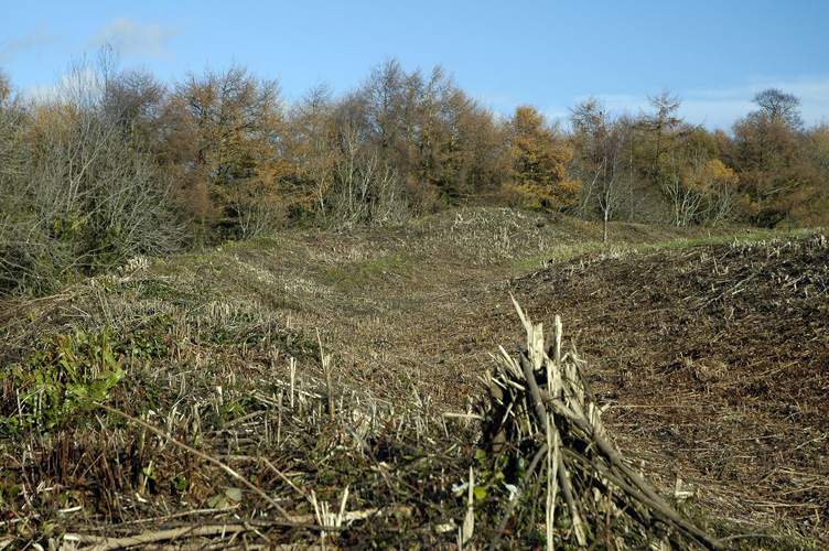
A short walk uphill from the lane at ST4634 9281 along the signed path leads to the hillfort entrance at it's NE gateworks. The ground vegetation had been recently machined to give maximun exposure to it's features. It's an atmospheric place, larger and far more complex that I'd expected. It occupies a prominent hilltop and extending NW/SE ridge, all covered in well defined earthworks and features. There is a further banked 'outpost' visible from the entrance path, and on the left, shortly after leaving the lane.
sem have visited here

Byll writes: I visited on 14 Aug 2010 and after a steep climb on the south facing side crossed a style to reach the bottom of the outer rampart.Brambles were taking hold on the ramparts and the annex outside the gate to the west but the main enclosure was long grass with occasional sprouts of bracken coming through. I did not find any Cadw interpretation boards.
I left by an easier route from the gate on the north side along the southeast corner of a field rejoining the road at the top of the hill from where I had parked my car. There are impressive double ramparts and a secluded but friendly ambience on a warm arfternoon even with a bit of drizzle. I met two other walkers who had arrived from a different direction.
There is parking space to two or three cars on a verge on the corner at the bottom of the hill, the easiest approach is probably to walk up the road to the gate on the right at the top of the hill and around the hedge on the left of the corn field to the path through the woods to the north side of the hillfort. It might be possible to park at the top of the hill but the road is generally narrow and twisty, so the wider area on the corner with the gateways is not an ideal parking area.
Note: New Bat Walk at dusk, Llanmelin Hillfort, 11th September
You may be viewing yesterday's version of this page. To see the most up to date information please register for a free account.


Do not use the above information on other web sites or publications without permission of the contributor.
Click here to see more info for this site
Nearby sites
Key: Red: member's photo, Blue: 3rd party photo, Yellow: other image, Green: no photo - please go there and take one, Grey: site destroyed
Download sites to:
KML (Google Earth)
GPX (GPS waypoints)
CSV (Garmin/Navman)
CSV (Excel)
To unlock full downloads you need to sign up as a Contributory Member. Otherwise downloads are limited to 50 sites.
Turn off the page maps and other distractions
Nearby sites listing. In the following links * = Image available
282m NE 44° Llan-melin wood Earthwork Misc. Earthwork (ST463928)
2.0km SSW 212° Five Lanes Round Barrow (A) Round Barrow(s) (ST45019091)
2.0km SSW 212° Five Lanes Round Barrow (B) Round Barrow(s) (ST45019090)
2.1km WNW 288° Gray Hill Cairn Cemetery* Barrow Cemetery (ST4408693273)
2.2km SSE 157° Cult Temple at Venta Silurum* Ancient Temple (ST4695890564)
2.2km SSE 157° Venta Silurum Settlement* Ancient Village or Settlement (ST46959056)
2.2km SSW 198° Middle Hendre Round Barrow(s) (ST454905)
2.2km SSE 159° Silurum Stone* Marker Stone (ST46879049)
2.5km WNW 291° Gray Hill circle* Stone Circle (ST43809353)
2.5km WNW 292° Gray Hill stone row* Standing Stone (Menhir) (ST43769357)
2.9km WNW 289° Gray Hill summit cairn* Round Cairn (ST43399355)
3.0km SSW 213° Woodcock Hill Barrow Round Barrow(s) (ST44449008)
3.3km SE 135° Crick Round Barrow* Round Barrow(s) (ST48449025)
3.5km WNW 295° Forresters' Oaks Round Barrow* Round Barrow(s) (ST42929410)
3.6km SW 231° Carrow Hill Round Barrow Round Barrow(s) (ST43309035)
3.8km SW 226° The Larches Camp* Hillfort (ST433900)
3.9km SW 233° Carrow Hill Round Barrow Pair Round Barrow(s) (ST42999029)
4.1km ESE 120° Mathern Round Barrow(s) (ST496905)
4.2km NE 50° Itton Cross (St Deiniol's)* Ancient Cross (ST4933095290)
4.3km NNW 341° y Garn Llwyd* Chambered Tomb (ST44769674)
4.4km E 95° Willis Hill Ancient Village or Settlement (ST50519216)
4.8km WNW 293° Llanvaches 1* Round Barrow(s) (ST41699455)
4.8km WNW 293° Llanvaches 2* Round Barrow(s) (ST41669455)
4.8km S 191° Llanfihangel Rogiet Churchyard Cross* Ancient Cross (ST4512087850)
5.1km E 93° NOT SET
View more nearby sites and additional images


 We would like to know more about this location. Please feel free to add a brief description and any relevant information in your own language.
 Wir möchten mehr über diese Stätte erfahren. Bitte zögern Sie nicht, eine kurze Beschreibung und relevante Informationen in Deutsch hinzuzufügen.
 Nous aimerions en savoir encore un peu sur les lieux. S'il vous plaît n'hesitez pas à ajouter une courte description et tous les renseignements pertinents dans votre propre langue.
 Quisieramos informarnos un poco más de las lugares. No dude en añadir una breve descripción y otros datos relevantes en su propio idioma.