

<< Our Photo Pages >> y Garn Llwyd - Chambered Tomb in Wales in Monmouthshire
Submitted by TheCaptain on Thursday, 03 September 2015 Page Views: 12414
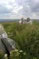
Neolithic and Bronze AgeSite Name: y Garn Llwyd Alternative Name: Gaer LlwydCountry: Wales County: Monmouthshire Type: Chambered Tomb
Nearest Town: Caerleon Nearest Village: Gaer-llwyd
Map Ref: ST44769674 Landranger Map Number: 171
Latitude: 51.666708N Longitude: 2.800117W
Condition:
| 5 | Perfect |
| 4 | Almost Perfect |
| 3 | Reasonable but with some damage |
| 2 | Ruined but still recognisable as an ancient site |
| 1 | Pretty much destroyed, possibly visible as crop marks |
| 0 | No data. |
| -1 | Completely destroyed |
| 5 | Superb |
| 4 | Good |
| 3 | Ordinary |
| 2 | Not Good |
| 1 | Awful |
| 0 | No data. |
| 5 | Can be driven to, probably with disabled access |
| 4 | Short walk on a footpath |
| 3 | Requiring a bit more of a walk |
| 2 | A long walk |
| 1 | In the middle of nowhere, a nightmare to find |
| 0 | No data. |
| 5 | co-ordinates taken by GPS or official recorded co-ordinates |
| 4 | co-ordinates scaled from a detailed map |
| 3 | co-ordinates scaled from a bad map |
| 2 | co-ordinates of the nearest village |
| 1 | co-ordinates of the nearest town |
| 0 | no data |
Internal Links:
External Links:
I have visited· I would like to visit
Geojazz visited on 2nd May 2021 - their rating: Cond: 2 Amb: 2 Access: 1 The hedge has been allowed to grow completely around the stones so that only the very tip of the tallest is now showing. See photograph. Impossible to see from the main road but walked a little way up the minor road where there is a gap in the hedge for a new build property and was able to zoom in with the camera.
hamish TheCaptain have visited here
")
There are also a few other large slabs of stone lying within the same field in the vicinity of the dolmen.
Original Page by Vicky Morgan
You may be viewing yesterday's version of this page. To see the most up to date information please register for a free account.
")
")
")
")
")
")
")
")
")
Do not use the above information on other web sites or publications without permission of the contributor.
Click here to see more info for this site
Nearby sites
Key: Red: member's photo, Blue: 3rd party photo, Yellow: other image, Green: no photo - please go there and take one, Grey: site destroyed
Download sites to:
KML (Google Earth)
GPX (GPS waypoints)
CSV (Garmin/Navman)
CSV (Excel)
To unlock full downloads you need to sign up as a Contributory Member. Otherwise downloads are limited to 50 sites.
Turn off the page maps and other distractions
Nearby sites listing. In the following links * = Image available
2.0km NNW 340° Gaer Fawr (Monmouthshire) Hillfort (ST441986)
2.3km WNW 289° Golden Hill Earthwork Hillfort (ST42579753)
3.1km N 2° Cwrt-Y-Gaer Misc. Earthwork (ST449998)
3.2km SW 214° Forresters' Oaks Round Barrow* Round Barrow(s) (ST42929410)
3.3km SSW 197° Gray Hill stone row* Standing Stone (Menhir) (ST43769357)
3.3km SSW 196° Gray Hill circle* Stone Circle (ST43809353)
3.5km SSW 203° Gray Hill summit cairn* Round Cairn (ST43399355)
3.5km S 190° Gray Hill Cairn Cemetery* Barrow Cemetery (ST4408693273)
3.6km NW 325° Camp Farm* Misc. Earthwork (ST427997)
3.8km SW 234° Llanvaches 1* Round Barrow(s) (ST41699455)
3.8km SW 234° Llanvaches 2* Round Barrow(s) (ST41669455)
4.2km SSE 158° Llan-melin wood Earthwork Misc. Earthwork (ST463928)
4.3km SSE 161° Llanmelin Wood* Hillfort (ST46109260)
4.4km E 79° Chepstow Park Wood Cairn Cairn (ST491975)
4.8km ESE 107° Itton Cross (St Deiniol's)* Ancient Cross (ST4933095290)
5.0km NNW 331° Earthwork Misc. Earthwork (SO424011)
5.7km SE 140° NOT SET
5.7km SW 220° Castell Prin* Hillfort (ST410924)
5.8km S 177° Five Lanes Round Barrow (A) Round Barrow(s) (ST45019091)
5.8km S 177° Five Lanes Round Barrow (B) Round Barrow(s) (ST45019090)
6.3km S 174° Middle Hendre Round Barrow(s) (ST454905)
6.6km SSE 160° Cult Temple at Venta Silurum* Ancient Temple (ST4695890564)
6.6km SSW 192° Carrow Hill Round Barrow Round Barrow(s) (ST43309035)
6.6km SSE 160° Venta Silurum Settlement* Ancient Village or Settlement (ST46959056)
6.6km SSE 161° Silurum Stone* Marker Stone (ST46879049)
View more nearby sites and additional images


 We would like to know more about this location. Please feel free to add a brief description and any relevant information in your own language.
 Wir möchten mehr über diese Stätte erfahren. Bitte zögern Sie nicht, eine kurze Beschreibung und relevante Informationen in Deutsch hinzuzufügen.
 Nous aimerions en savoir encore un peu sur les lieux. S'il vous plaît n'hesitez pas à ajouter une courte description et tous les renseignements pertinents dans votre propre langue.
 Quisieramos informarnos un poco más de las lugares. No dude en añadir una breve descripción y otros datos relevantes en su propio idioma.