


<< Our Photo Pages >> Jacobs Well - Holy Well or Sacred Spring in England in Surrey
Submitted by amunptah on Sunday, 16 February 2025 Page Views: 11735
Springs and Holy WellsSite Name: Jacobs Well Alternative Name: St Edward's Well,Country: England County: Surrey Type: Holy Well or Sacred Spring
Nearest Town: Guildford Nearest Village: Jacobs Well
Map Ref: TQ004538
Latitude: 51.274513N Longitude: 0.562065W
Condition:
| 5 | Perfect |
| 4 | Almost Perfect |
| 3 | Reasonable but with some damage |
| 2 | Ruined but still recognisable as an ancient site |
| 1 | Pretty much destroyed, possibly visible as crop marks |
| 0 | No data. |
| -1 | Completely destroyed |
| 5 | Superb |
| 4 | Good |
| 3 | Ordinary |
| 2 | Not Good |
| 1 | Awful |
| 0 | No data. |
| 5 | Can be driven to, probably with disabled access |
| 4 | Short walk on a footpath |
| 3 | Requiring a bit more of a walk |
| 2 | A long walk |
| 1 | In the middle of nowhere, a nightmare to find |
| 0 | No data. |
| 5 | co-ordinates taken by GPS or official recorded co-ordinates |
| 4 | co-ordinates scaled from a detailed map |
| 3 | co-ordinates scaled from a bad map |
| 2 | co-ordinates of the nearest village |
| 1 | co-ordinates of the nearest town |
| 0 | no data |
Internal Links:
External Links:
I have visited· I would like to visit
pakita13130 would like to visit
AJHL visited on 21st Sep 2024 - their rating: Cond: 5 Amb: 3 Access: 5 Nice well but lacks character due to modern well head
")
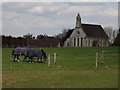
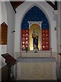
Associated with Edward the Confessor who became the first 'patron saint' of England. He is believed to have had a hunting lodge in the site. One presumes that the water had healing powers but the present structure would prevent access. It is located in an area called Jacobwell which may indicate an alternative name in the Sutton Park estate near the catholic church.
Now the well, with a more modern well-house, stands within the grounds of the church of St Edward the Confessor, and can be accessed via the graveyard.
You may be viewing yesterday's version of this page. To see the most up to date information please register for a free account.
")
")
")
")
Do not use the above information on other web sites or publications without permission of the contributor.
Nearby Images from Geograph Britain and Ireland:
©2012(licence)
©2015(licence)
©2015(licence)
©2015(licence)
©2015(licence)
The above images may not be of the site on this page, they are loaded from Geograph.
Please Submit an Image of this site or go out and take one for us!
Click here to see more info for this site
Nearby sites
Key: Red: member's photo, Blue: 3rd party photo, Yellow: other image, Green: no photo - please go there and take one, Grey: site destroyed
Download sites to:
KML (Google Earth)
GPX (GPS waypoints)
CSV (Garmin/Navman)
CSV (Excel)
To unlock full downloads you need to sign up as a Contributory Member. Otherwise downloads are limited to 50 sites.
Turn off the page maps and other distractions
Nearby sites listing. In the following links * = Image available
822m WSW 257° Whitmoor Common* Round Barrow(s) (SU996536)
4.6km S 190° Guildford Museum* Museum (SU9968349258)
5.5km SSE 163° Tyting Farm Bowl Barrow* Round Barrow(s) (TQ02124857)
5.7km S 191° Artington Spring* Holy Well or Sacred Spring (SU994482)
5.7km WNW 287° Bullswater Common Barrows Barrow Cemetery (SU9487555356)
6.0km NNW 346° Horsell Birch Natural Stone / Erratic / Other Natural Feature (SU98805956)
6.0km NE 36° Pyrford Stone* Marker Stone (TQ0382258782)
6.1km SSE 159° St Martha's on the Hill Earth Circles* Misc. Earthwork (TQ027482)
6.1km N 11° Horsell Common W* Barrow Cemetery (TQ01405980)
6.1km NNE 13° Horsell Common E* Round Barrow(s) (TQ01615977)
6.5km SSE 152° Lid Well* Holy Well or Sacred Spring (TQ03554815)
7.4km SE 138° Weston Wood Platform Mound* Round Barrow(s) (TQ055484)
7.4km NE 35° Jack Temple Healing Centre* Modern Stone Circle etc (TQ045600)
7.4km NW 321° St John the Baptist's Well (Bisley)* Holy Well or Sacred Spring (SU956595)
7.5km SE 137° Weston Woods Cromlech* Standing Stones (TQ05644839)
7.6km SE 141° Albury Fishponds* Natural Stone / Erratic / Other Natural Feature (TQ053480)
7.7km SE 134° The Silent Pool* Holy Well or Sacred Spring (TQ0606148582)
8.6km SE 139° Albury Park Mound* Round Barrow(s) (TQ062474)
8.9km NE 55° Bowl barrow west of Cockcrow Hill* Round Barrow(s) (TQ07635910)
9.2km NE 56° Cockrow Hill Bell Barrow* Round Barrow(s) (TQ07905915)
9.9km NE 55° Red Hill (Surrey)* Henge (TQ08505961)
10.1km NW 319° New England Barrow Round Barrow(s) (SU93616129)
10.1km N 355° Chobham Common (1)* Misc. Earthwork (SU994639)
10.5km NW 317° West End Common Barrows* Barrow Cemetery (SU931614)
10.9km NNW 345° Albury Bottom Enclosure* Misc. Earthwork (SU97426430)
View more nearby sites and additional images


 We would like to know more about this location. Please feel free to add a brief description and any relevant information in your own language.
 Wir möchten mehr über diese Stätte erfahren. Bitte zögern Sie nicht, eine kurze Beschreibung und relevante Informationen in Deutsch hinzuzufügen.
 Nous aimerions en savoir encore un peu sur les lieux. S'il vous plaît n'hesitez pas à ajouter une courte description et tous les renseignements pertinents dans votre propre langue.
 Quisieramos informarnos un poco más de las lugares. No dude en añadir una breve descripción y otros datos relevantes en su propio idioma.