 with our Megalithic Portal iPhone app")


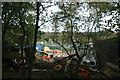
<< Our Photo Pages >> Weston Wood Platform Mound - Round Barrow(s) in England in Surrey
Submitted by Eileen on Tuesday, 01 February 2005 Page Views: 7431
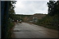
Neolithic and Bronze AgeSite Name: Weston Wood Platform MoundCountry: England County: Surrey Type: Round Barrow(s)
Nearest Town: Guildford Nearest Village: Albury
Map Ref: TQ055484
Latitude: 51.225053N Longitude: 0.490568W
Condition:
| 5 | Perfect |
| 4 | Almost Perfect |
| 3 | Reasonable but with some damage |
| 2 | Ruined but still recognisable as an ancient site |
| 1 | Pretty much destroyed, possibly visible as crop marks |
| 0 | No data. |
| -1 | Completely destroyed |
| 5 | Superb |
| 4 | Good |
| 3 | Ordinary |
| 2 | Not Good |
| 1 | Awful |
| 0 | No data. |
| 5 | Can be driven to, probably with disabled access |
| 4 | Short walk on a footpath |
| 3 | Requiring a bit more of a walk |
| 2 | A long walk |
| 1 | In the middle of nowhere, a nightmare to find |
| 0 | No data. |
| 5 | co-ordinates taken by GPS or official recorded co-ordinates |
| 4 | co-ordinates scaled from a detailed map |
| 3 | co-ordinates scaled from a bad map |
| 2 | co-ordinates of the nearest village |
| 1 | co-ordinates of the nearest town |
| 0 | no data |
Internal Links:
External Links:
")
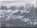
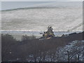
Note: Destruction of a barrow by sand extraction. Those of a nervous disposition may wish to look away.
You may be viewing yesterday's version of this page. To see the most up to date information please register for a free account.
")
")
Do not use the above information on other web sites or publications without permission of the contributor.
Nearby Images from Geograph Britain and Ireland:
©2013(licence)
©2012(licence)
©2012(licence)
©2012(licence)
©2013(licence)
The above images may not be of the site on this page, they are loaded from Geograph.
Please Submit an Image of this site or go out and take one for us!
Click here to see more info for this site
Nearby sites
Key: Red: member's photo, Blue: 3rd party photo, Yellow: other image, Green: no photo - please go there and take one, Grey: site destroyed
Download sites to:
KML (Google Earth)
GPX (GPS waypoints)
CSV (Garmin/Navman)
CSV (Excel)
To unlock full downloads you need to sign up as a Contributory Member. Otherwise downloads are limited to 50 sites.
Turn off the page maps and other distractions
Nearby sites listing. In the following links * = Image available
140m E 95° Weston Woods Cromlech* Standing Stones (TQ05644839)
447m SSW 208° Albury Fishponds* Natural Stone / Erratic / Other Natural Feature (TQ053480)
588m ENE 73° The Silent Pool* Holy Well or Sacred Spring (TQ0606148582)
1.2km SSE 146° Albury Park Mound* Round Barrow(s) (TQ062474)
2.0km W 264° Lid Well* Holy Well or Sacred Spring (TQ03554815)
2.8km W 267° St Martha's on the Hill Earth Circles* Misc. Earthwork (TQ027482)
3.4km W 274° Tyting Farm Bowl Barrow* Round Barrow(s) (TQ02124857)
5.9km W 280° Guildford Museum* Museum (SU9968349258)
6.1km W 269° Artington Spring* Holy Well or Sacred Spring (SU994482)
6.2km ESE 116° Abinger Manor* Ancient Village or Settlement (TQ112458)
6.3km E 95° Deerleap Wood* Round Barrow(s) (TQ118480)
6.4km SE 126° Felday* Hillfort (TQ10824475)
6.5km W 276° St. Edward's Well* Holy Well or Sacred Spring (SU9949)
7.3km SE 138° Holmbury Camp Hillfort (TQ105430)
7.4km NW 318° Jacobs Well* Holy Well or Sacred Spring (TQ004538)
7.9km NW 313° Whitmoor Common* Round Barrow(s) (SU996536)
9.4km ESE 109° Mag's Well (Abinger Forest)* Holy Well or Sacred Spring (TQ145455)
9.8km E 88° Milton Heath* Round Barrow(s) (TQ15294890)
9.8km SE 129° Leith Hill Place* Natural Stone / Erratic / Other Natural Feature (TQ1324542344)
10.5km N 352° Pyrford Stone* Marker Stone (TQ0382258782)
10.7km SW 235° Lady Well (Tuesley)* Holy Well or Sacred Spring (SU968421)
10.8km ESE 115° Anstiebury Camp* Hillfort (TQ1534244008)
10.9km SSW 205° The Dragonstones Modern Stone Circle etc (TQ0105038489)
10.9km NNE 12° Bowl barrow west of Cockcrow Hill* Round Barrow(s) (TQ07635910)
11.0km NNE 14° Cockrow Hill Bell Barrow* Round Barrow(s) (TQ07905915)
View more nearby sites and additional images


 We would like to know more about this location. Please feel free to add a brief description and any relevant information in your own language.
 Wir möchten mehr über diese Stätte erfahren. Bitte zögern Sie nicht, eine kurze Beschreibung und relevante Informationen in Deutsch hinzuzufügen.
 Nous aimerions en savoir encore un peu sur les lieux. S'il vous plaît n'hesitez pas à ajouter une courte description et tous les renseignements pertinents dans votre propre langue.
 Quisieramos informarnos un poco más de las lugares. No dude en añadir una breve descripción y otros datos relevantes en su propio idioma.