

<< Our Photo Pages >> St Cuthbert's Church (Milburn) - Ancient Cross in England in Cumbria
Submitted by Anne T on Saturday, 10 February 2018 Page Views: 1815
Early Medieval (Dark Age)Site Name: St Cuthbert's Church (Milburn)Country: England County: Cumbria Type: Ancient Cross
Nearest Town: Penrith Nearest Village: Milburn
Map Ref: NY6535929163
Latitude: 54.656361N Longitude: 2.538457W
Condition:
| 5 | Perfect |
| 4 | Almost Perfect |
| 3 | Reasonable but with some damage |
| 2 | Ruined but still recognisable as an ancient site |
| 1 | Pretty much destroyed, possibly visible as crop marks |
| 0 | No data. |
| -1 | Completely destroyed |
| 5 | Superb |
| 4 | Good |
| 3 | Ordinary |
| 2 | Not Good |
| 1 | Awful |
| 0 | No data. |
| 5 | Can be driven to, probably with disabled access |
| 4 | Short walk on a footpath |
| 3 | Requiring a bit more of a walk |
| 2 | A long walk |
| 1 | In the middle of nowhere, a nightmare to find |
| 0 | No data. |
| 5 | co-ordinates taken by GPS or official recorded co-ordinates |
| 4 | co-ordinates scaled from a detailed map |
| 3 | co-ordinates scaled from a bad map |
| 2 | co-ordinates of the nearest village |
| 1 | co-ordinates of the nearest town |
| 0 | no data |
Internal Links:
External Links:
I have visited· I would like to visit
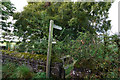
Anne T visited on 9th Feb 2018 - their rating: Cond: 2 Amb: 4 Access: 5 Ancient cross and pre-Conquest sundial, Milburn, Cumbria: We scouted all around the churchyard for this cross, only to realise it was at the head of the access road from the village, so back-tracked to find it. It sits right by the northern gate post and we had mistaken it for part of the gate/fence structure, then we checked the grid reference and saw the hole in the top of the shaft, presumably either for another section or a smaller cross.
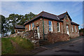
Going back down to the church, I found the pre-Conquest sundial, which is low down on the exterior stone door jamb of the western side of the south door. Thankfully I was able to pull up the Corpus of Anglo Saxon stone sculpture photograph to help me in the growing dusk.
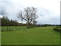
The churchyard is really nicely kept and the Crowdundle Beck/Milburn Beck runs by the western side of the churchyard. A remote, by lovely spot.
 (PID:177963)")
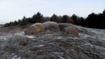
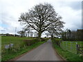
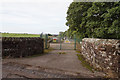
Just west of the defended village of Milburn lies the church of St. Cuthbert, which is reached by a gated lane. At NY 65359 29163, at the entrance to this approach to the church, right by the northern gatepost, sits this remnant of red sandstone cross shaft. Described as Pastscape Monument No. 13543, it sits approximately 80 cms above the surrounding earth and vegetation, although no sign of the cross base within which it sits, could be seen at the time of our visit.
Looking at the top of the cross shaft, it has a small hole as if another segment or cross was inserted into it.
Driving/walking down the lane towards the church itself, at NY 65200 29062, is a pre-Conquest sun dial, low down in the western stone jamb of the door. It takes a little bit of finding, but worth looking for.
The churchyard is well tended, with the pretty Crowdundle/Milburn Beck running along its western boundary. A really pretty spot.
You may be viewing yesterday's version of this page. To see the most up to date information please register for a free account.
 (PID:177964)")
 (PID:177962)")
 (PID:177959)")
Do not use the above information on other web sites or publications without permission of the contributor.
Nearby Images from Geograph Britain and Ireland:
©2021(licence)
©2015(licence)
©2021(licence)
©2015(licence)
©2015(licence)
The above images may not be of the site on this page, they are loaded from Geograph.
Please Submit an Image of this site or go out and take one for us!
Click here to see more info for this site
Nearby sites
Key: Red: member's photo, Blue: 3rd party photo, Yellow: other image, Green: no photo - please go there and take one, Grey: site destroyed
Download sites to:
KML (Google Earth)
GPX (GPS waypoints)
CSV (Garmin/Navman)
CSV (Excel)
To unlock full downloads you need to sign up as a Contributory Member. Otherwise downloads are limited to 50 sites.
Turn off the page maps and other distractions
Nearby sites listing. In the following links * = Image available
77m NW 321° Keld Well (Milburn) Holy Well or Sacred Spring (NY6531129224)
2.6km WSW 258° St Edmund's Church (Newbeggin)* Ancient Cross (NY6278428660)
3.4km NNW 347° St Lawrence's Church (Kirkland)* Ancient Cross (NY6460632528)
3.9km N 356° St Andrew's Well (Culgaith)* Holy Well or Sacred Spring (NY6514733049)
4.3km SW 231° Roman Milestone (Temple Sowerby)* Marker Stone (NY6199026444)
5.6km NNW 337° St Luke's Church (Townhead)* Ancient Cross (NY6317734328)
5.7km W 269° Winderwath Stone Circle* Stone Circle (NY5960729085)
7.9km S 183° Lady Well (Bewley Castle) Holy Well or Sacred Spring (NY6485021260)
8.5km SW 221° Powdonnet Well (Morland)* Holy Well or Sacred Spring (NY5970722786)
8.7km SSW 201° Bessygarth Well (King's Meaburn)* Holy Well or Sacred Spring (NY6210921100)
8.9km WNW 288° St. Cuthbert's Church (Edenhall)* Ancient Cross (NY5689832046)
9.1km WNW 289° Edenhall Cross (Langwathby)* Ancient Cross (NY5676732230)
9.3km W 276° Giants Cave Holy Well (Edenhall)* Holy Well or Sacred Spring (NY5610030200)
9.3km W 275° St Ninian's Preconquest Monastery (Ninekirks)* Ancient Village or Settlement (NY5607129981)
9.3km W 276° Giant's Cave (Cumbria)* Cave or Rock Shelter (NY56093027)
9.4km WNW 288° St Cuthbert's Well (Edenhall Park)* Holy Well or Sacred Spring (NY564321)
9.4km W 274° St Ninian's Church (Ninekirks)* Ancient Cross (NY5593629962)
9.5km WSW 252° Leacet Hill* Cairn (NY563263)
11.0km SW 236° Low Well (Great Strickland)* Holy Well or Sacred Spring (NY56242302)
11.3km NW 317° Little Meg* Stone Circle (NY5769037479)
11.5km NW 314° Long Meg And Her Daughters* Stone Circle (NY57113721)
11.5km NW 314° Long Meg* Standing Stone (Menhir) (NY57063716)
11.9km NW 312° Hunsonby Cursus Cursus (NY56543719)
12.1km NW 319° Addingham Cross* Ancient Cross (NY57443829)
12.1km WSW 256° St Cuthbert's Well (Clifton)* Holy Well or Sacred Spring (NY5359326336)
View more nearby sites and additional images


 We would like to know more about this location. Please feel free to add a brief description and any relevant information in your own language.
 Wir möchten mehr über diese Stätte erfahren. Bitte zögern Sie nicht, eine kurze Beschreibung und relevante Informationen in Deutsch hinzuzufügen.
 Nous aimerions en savoir encore un peu sur les lieux. S'il vous plaît n'hesitez pas à ajouter une courte description et tous les renseignements pertinents dans votre propre langue.
 Quisieramos informarnos un poco más de las lugares. No dude en añadir una breve descripción y otros datos relevantes en su propio idioma.