

<< Our Photo Pages >> Low Well (Great Strickland) - Holy Well or Sacred Spring in England in Cumbria
Submitted by Anne T on Tuesday, 12 July 2022 Page Views: 578
Springs and Holy WellsSite Name: Low Well (Great Strickland)Country: England County: Cumbria Type: Holy Well or Sacred Spring
Nearest Town: Eamont Bridge Nearest Village: Great Strickland
Map Ref: NY56242302
Latitude: 54.600449N Longitude: 2.678872W
Condition:
| 5 | Perfect |
| 4 | Almost Perfect |
| 3 | Reasonable but with some damage |
| 2 | Ruined but still recognisable as an ancient site |
| 1 | Pretty much destroyed, possibly visible as crop marks |
| 0 | No data. |
| -1 | Completely destroyed |
| 5 | Superb |
| 4 | Good |
| 3 | Ordinary |
| 2 | Not Good |
| 1 | Awful |
| 0 | No data. |
| 5 | Can be driven to, probably with disabled access |
| 4 | Short walk on a footpath |
| 3 | Requiring a bit more of a walk |
| 2 | A long walk |
| 1 | In the middle of nowhere, a nightmare to find |
| 0 | No data. |
| 5 | co-ordinates taken by GPS or official recorded co-ordinates |
| 4 | co-ordinates scaled from a detailed map |
| 3 | co-ordinates scaled from a bad map |
| 2 | co-ordinates of the nearest village |
| 1 | co-ordinates of the nearest town |
| 0 | no data |
Internal Links:
External Links:
 (PID:244538)")
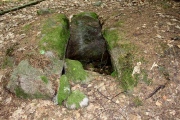
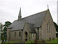
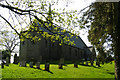
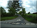
This well is located immediately to the north east of St Barnabas's Church in Great Strickland. Whilst the church was only built in 1870, the raised site upon which the church is built looks far older.
This well looks too ornate to be a simple village water supply, as it has a proper well housing, with steps leading down into a circular well chamber. The iron gate giving access to the waters was very firmly chained into place, so it was not possible to check for any scoops or buckets to draw the water.
The well is listed as medieval in date on the Cumbria Historic Environment Record (number 43225); a 2008 survey was conducted which included this well as part of an assessment for a pipeline.
Does anyone have any information about this well, and its origins, please? Are you able to confirm if it is a simple water supply, or does it have holy or healing connections/associations? Thank you.
You may be viewing yesterday's version of this page. To see the most up to date information please register for a free account.
 (PID:244542)")
 (PID:244541)")
 (PID:244540)")
 (PID:244539)")
Do not use the above information on other web sites or publications without permission of the contributor.
Nearby Images from Geograph Britain and Ireland:
©2005(licence)
©2007(licence)
©2014(licence)
©2006(licence)
©2007(licence)
The above images may not be of the site on this page, they are loaded from Geograph.
Please Submit an Image of this site or go out and take one for us!
Click here to see more info for this site
Nearby sites
Key: Red: member's photo, Blue: 3rd party photo, Yellow: other image, Green: no photo - please go there and take one, Grey: site destroyed
Download sites to:
KML (Google Earth)
GPX (GPS waypoints)
CSV (Garmin/Navman)
CSV (Excel)
To unlock full downloads you need to sign up as a Contributory Member. Otherwise downloads are limited to 50 sites.
Turn off the page maps and other distractions
Nearby sites listing. In the following links * = Image available
2.8km WNW 296° Trainford Brow Long Barrow* Long Barrow (NY5369724313)
2.9km WNW 296° Low Moor (Cumbria)* Long Barrow (NY53642431)
3.3km N 0° Leacet Hill* Cairn (NY563263)
3.5km E 93° Powdonnet Well (Morland)* Holy Well or Sacred Spring (NY5970722786)
4.2km NW 321° St Cuthbert's Well (Clifton)* Holy Well or Sacred Spring (NY5359326336)
4.3km NW 313° Clifton Stones* Standing Stones (NY53132593)
4.3km SSW 193° Shapbeck Plantation* Stone Circle (NY55261886)
4.5km WNW 284° Castlesteads (Lowther)* Misc. Earthwork (NY51892412)
4.6km WNW 288° St Michael (Lowther)* Ancient Cross (NY51902445)
4.6km SSW 204° Out Scar Ancient Village or Settlement (NY543188)
4.7km SW 220° Knipe Scar Tumuli* Round Cairn (NY5319019438)
4.9km WNW 296° Castlesteads (Yanwath Wood)* Ancient Village or Settlement (NY5185725187)
4.9km SW 220° Knipe Scar Iron Age Hillfort* Hillfort (NY5300219287)
4.9km WNW 296° Castlesteads (Tirril) Ancient Village or Settlement (NY518252)
5.0km SSW 195° Wilson Scar Stone Circle (NY549182)
5.0km SW 221° Knipe Scar* Stone Circle (NY52881930)
5.1km NW 312° Lowther Woodhouse Stone Row / Alignment (NY525265)
5.2km W 259° Mark's Well (Helton)* Holy Well or Sacred Spring (NY5114222090)
5.3km S 173° Gunnerkeld* Stone Circle (NY56821775)
6.2km ESE 108° Bessygarth Well (King's Meaburn)* Holy Well or Sacred Spring (NY6210921100)
6.2km SW 219° Bampton Grange Cross* Ancient Cross (NY5232218227)
6.2km SSW 202° Benny Howe Round Barrow(s) (NY53901729)
6.3km SSE 168° Cross Stone of Keverigg Ancient Cross (NY57511687)
6.3km SSE 168° Cross Shaped Stone of Keverigg* Ancient Cross (NY5751916849)
6.3km W 272° Skirsgill Hill* Ancient Village or Settlement (NY4990923267)
View more nearby sites and additional images


 We would like to know more about this location. Please feel free to add a brief description and any relevant information in your own language.
 Wir möchten mehr über diese Stätte erfahren. Bitte zögern Sie nicht, eine kurze Beschreibung und relevante Informationen in Deutsch hinzuzufügen.
 Nous aimerions en savoir encore un peu sur les lieux. S'il vous plaît n'hesitez pas à ajouter une courte description et tous les renseignements pertinents dans votre propre langue.
 Quisieramos informarnos un poco más de las lugares. No dude en añadir una breve descripción y otros datos relevantes en su propio idioma.