


<< Our Photo Pages >> Bessygarth Well (King's Meaburn) - Holy Well or Sacred Spring in England in Cumbria
Submitted by Anne T on Tuesday, 31 July 2018 Page Views: 2159
Springs and Holy WellsSite Name: Bessygarth Well (King''s Meaburn)Country: England County: Cumbria Type: Holy Well or Sacred Spring
Nearest Town: Penrith Nearest Village: King's Meaburn
Map Ref: NY6210921100
Latitude: 54.583670N Longitude: 2.587784W
Condition:
| 5 | Perfect |
| 4 | Almost Perfect |
| 3 | Reasonable but with some damage |
| 2 | Ruined but still recognisable as an ancient site |
| 1 | Pretty much destroyed, possibly visible as crop marks |
| 0 | No data. |
| -1 | Completely destroyed |
| 5 | Superb |
| 4 | Good |
| 3 | Ordinary |
| 2 | Not Good |
| 1 | Awful |
| 0 | No data. |
| 5 | Can be driven to, probably with disabled access |
| 4 | Short walk on a footpath |
| 3 | Requiring a bit more of a walk |
| 2 | A long walk |
| 1 | In the middle of nowhere, a nightmare to find |
| 0 | No data. |
| 5 | co-ordinates taken by GPS or official recorded co-ordinates |
| 4 | co-ordinates scaled from a detailed map |
| 3 | co-ordinates scaled from a bad map |
| 2 | co-ordinates of the nearest village |
| 1 | co-ordinates of the nearest town |
| 0 | no data |
Internal Links:
External Links:
I have visited· I would like to visit
Anne T visited on 30th Jul 2018 - their rating: Cond: 3 Amb: 4 Access: 4 Bessygarth Well, King's Meaburn: This is a very old village, with a scheduled 17th century barn opposite the bus stop next to the village hall where we parked. The village runs in a long ribbon along both sides of the road, with an incongruous caravan park tucked behind the village hall.
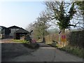
Despite being marked on the OS map, we couldn’t find this well at first, so asked someone who’d pulled up outside one of the cottages opposite. He was only visiting, but was kind enough to ask inside the house, and relayed a message, saying that “if there’s some old tin in the field, that’s the well”. We were told it was OK to go into the field, providing we ensured the gate was shut.
Andrew dropped a stone down it, and it sounded deep! There was a most peculiar solid cast iron ‘bowl’ deeply embedded into the ground next to the well. Was this the cap of an old pump?
The field behind the well is covered in lumps and bumps. Researching it when I got home, found it was the site of the medieval settlement.
 (PID:184387)")
Bessygarth Well is marked on the OS map, and is also recorded (briefly) as Pastscape Monument No. 1331196. The Pastscape entry says: "The (remains of the) well lies between the main street and the earthwork remains of two medieval crofts to the east of it. Scheduled."
More details about the village are given on Historic England List ID 928604, where the village is described as being pre-Conquest. More details can be found on Historic England List ID 1018935, which includes Bessygarth Well, but the only mention is similar to the Pastscape entry (above).
The well can be seen from the pavement, as corrugated iron sheets joined together to form a square, with abundant shrubbery emerging from this structure. There is a gate into the field at NY 62116 21080. We asked permission to go into the field, and were told to keep the gate firmly shut behind us.
Getting closer to the well, the pool of water (which is deep - we dropped a small pebble into it) can be seen through the cluster of shrubs and grass. There was a peculiar rusty iron 'bowl' which was deeply embedded into the earth at the corner of the well; is this the cap for the old village pump?
The area to the east of the well has the remains of building platforms and the lumps of building foundations.
You may be viewing yesterday's version of this page. To see the most up to date information please register for a free account.
 (PID:184389)")
 (PID:184388)")
 (PID:184386)")
Do not use the above information on other web sites or publications without permission of the contributor.
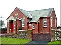
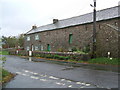
Nearby Images from Geograph Britain and Ireland:

©2007(licence)
©2010(licence)
©2008(licence)
©2017(licence)
©2019(licence)
The above images may not be of the site on this page, they are loaded from Geograph.
Please Submit an Image of this site or go out and take one for us!
Click here to see more info for this site
Nearby sites
Key: Red: member's photo, Blue: 3rd party photo, Yellow: other image, Green: no photo - please go there and take one, Grey: site destroyed
Download sites to:
KML (Google Earth)
GPX (GPS waypoints)
CSV (Garmin/Navman)
CSV (Excel)
To unlock full downloads you need to sign up as a Contributory Member. Otherwise downloads are limited to 50 sites.
Turn off the page maps and other distractions
Nearby sites listing. In the following links * = Image available
2.7km E 86° Lady Well (Bewley Castle) Holy Well or Sacred Spring (NY6485021260)
2.9km NW 305° Powdonnet Well (Morland)* Holy Well or Sacred Spring (NY5970722786)
5.3km N 358° Roman Milestone (Temple Sowerby)* Marker Stone (NY6199026444)
6.2km WNW 288° Low Well (Great Strickland)* Holy Well or Sacred Spring (NY56242302)
6.2km SW 227° Cross Stone of Keverigg Ancient Cross (NY57511687)
6.2km SW 227° Cross Shaped Stone of Keverigg* Ancient Cross (NY5751916849)
6.2km WSW 237° Gunnerkeld* Stone Circle (NY56821775)
6.3km S 179° Crosby Ravensworth Cross* Ancient Cross (NY6214314823)
6.5km SSW 210° Castlehowe Scar Stone Circle* Stone Circle (NY5874815472)
6.6km SSW 210° Castlehowe Scar Stone Row* Stone Row / Alignment (NY5873615412)
6.7km SW 215° Thunder Stone (Castlehowe Scar)* Natural Stone / Erratic / Other Natural Feature (NY5817615610)
6.7km SSW 201° Iron Hill North* Stone Circle (NY59631482)
6.8km SSW 213° Castlehow Stones Stone Row / Alignment (NY584154)
6.8km SSW 201° Iron Hill South* Stone Circle (NY59641476)
7.1km S 179° Crosby Ravensworth Stone Row* Multiple Stone Rows / Avenue (NY6212514022)
7.2km WSW 251° Shapbeck Plantation* Stone Circle (NY55261886)
7.6km N 5° St Edmund's Church (Newbeggin)* Ancient Cross (NY6278428660)
7.7km S 188° Ewe Close* Ancient Village or Settlement (NY61021348)
7.7km WSW 248° Wilson Scar Stone Circle (NY549182)
7.8km NW 311° Leacet Hill* Cairn (NY563263)
7.9km S 175° Howarcles Ancient Village or Settlement (NY627132)
8.0km SSW 202° Hardendale Timber Circle (NY590137)
8.1km WSW 253° Out Scar Ancient Village or Settlement (NY543188)
8.2km SSE 168° Raise Howe Cairn* Cairn (NY63711303)
8.3km SSW 199° Kalmott cairn circle* Ring Cairn (NY59301333)
View more nearby sites and additional images


 We would like to know more about this location. Please feel free to add a brief description and any relevant information in your own language.
 Wir möchten mehr über diese Stätte erfahren. Bitte zögern Sie nicht, eine kurze Beschreibung und relevante Informationen in Deutsch hinzuzufügen.
 Nous aimerions en savoir encore un peu sur les lieux. S'il vous plaît n'hesitez pas à ajouter une courte description et tous les renseignements pertinents dans votre propre langue.
 Quisieramos informarnos un poco más de las lugares. No dude en añadir una breve descripción y otros datos relevantes en su propio idioma.