
, Aubrey Burl")
<< Text Pages >> Cross Stone of Keverigg - Ancient Cross in England in Cumbria
Submitted by Anne T on Monday, 11 July 2022 Page Views: 1073
Early Medieval (Dark Age)Site Name: Cross Stone of KeveriggCountry: England County: Cumbria Type: Ancient Cross
Nearest Town: Shap
Map Ref: NY57511687
Latitude: 54.545292N Longitude: 2.658324W
Condition:
| 5 | Perfect |
| 4 | Almost Perfect |
| 3 | Reasonable but with some damage |
| 2 | Ruined but still recognisable as an ancient site |
| 1 | Pretty much destroyed, possibly visible as crop marks |
| 0 | No data. |
| -1 | Completely destroyed |
| 5 | Superb |
| 4 | Good |
| 3 | Ordinary |
| 2 | Not Good |
| 1 | Awful |
| 0 | No data. |
| 5 | Can be driven to, probably with disabled access |
| 4 | Short walk on a footpath |
| 3 | Requiring a bit more of a walk |
| 2 | A long walk |
| 1 | In the middle of nowhere, a nightmare to find |
| 0 | No data. |
| 5 | co-ordinates taken by GPS or official recorded co-ordinates |
| 4 | co-ordinates scaled from a detailed map |
| 3 | co-ordinates scaled from a bad map |
| 2 | co-ordinates of the nearest village |
| 1 | co-ordinates of the nearest town |
| 0 | no data |
Be the first person to rate this site - see the 'Contribute!' box in the right hand menu.
Internal Links:
External Links:
I have visited· I would like to visit
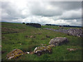
Anne T couldn't find on 9th Jul 2022 Cross Stone of Keverigg: The location of the stone was clearly marked on the Historic England Map search map, but despite my husband clambering (very carefully) over the dry stone wall and stock fence at the eastern end of the access land, he was unable to find the stone. There was considerable growth of grass and weeds in the area, and plenty of moss and lichen on the surrounding stones. He did, however, find the Cross Shaped Stone that MonumentMan has submitted (SID 52464), 23m away.
Shown on the old and modern (2022) OS maps, this boundary stone, inscribed with a cross, is recorded on the Old Cumbria Gazetteer as Cross Stone of Keverigg.
Using the grid reference given, the location of the stone is shown on the Historic England Map Search as a small black circle; there is no record of it in the Heritage Gateway.
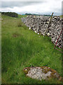
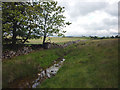
The stone is located almost at the junction of three dry stone walls, between the edge of the forestry and the dry stone wall/stock fence on its eastern side, and the Trainrigg Sike to its west. Please note that the stone is over the dry stone wall & stock fence from the access land, so some clambering is required to see it - please be careful not to damage any of the walls, which are already falling down in places.
We tried to find this stone in July 2022, but due to either the height of the grass, or the amount of moss/lichen on the stones in the area, were unable to identify this particular stone.
As MonumentMan says in his entry for the Cross Shaped Stone of Keverigg (Site ID 52464), there is an 11 year old photograph of the stone on Geograph - see Cross Stone of Keverigg.
You may be viewing yesterday's version of this page. To see the most up to date information please register for a free account.
Do not use the above information on other web sites or publications without permission of the contributor.
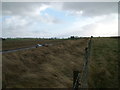
Nearby Images from Geograph Britain and Ireland:
©2011(licence)
©2011(licence)

©2014(licence)
©2011(licence)
©2008(licence)
The above images may not be of the site on this page, they are loaded from Geograph.
Please Submit an Image of this site or go out and take one for us!
Click here to see more info for this site
Nearby sites
Key: Red: member's photo, Blue: 3rd party photo, Yellow: other image, Green: no photo - please go there and take one, Grey: site destroyed
Download sites to:
KML (Google Earth)
GPX (GPS waypoints)
CSV (Garmin/Navman)
CSV (Excel)
To unlock full downloads you need to sign up as a Contributory Member. Otherwise downloads are limited to 50 sites.
Turn off the page maps and other distractions
Nearby sites listing. In the following links * = Image available
23m SSE 156° Cross Shaped Stone of Keverigg* Ancient Cross (NY5751916849)
1.1km NW 321° Gunnerkeld* Stone Circle (NY56821775)
1.4km SSE 152° Thunder Stone (Castlehowe Scar)* Natural Stone / Erratic / Other Natural Feature (NY5817615610)
1.7km SSE 148° Castlehow Stones Stone Row / Alignment (NY584154)
1.9km SE 138° Castlehowe Scar Stone Circle* Stone Circle (NY5874815472)
1.9km SE 139° Castlehowe Scar Stone Row* Stone Row / Alignment (NY5873615412)
2.3km SW 232° Skellaw Hill Tumulus* Round Barrow(s) (NY5565015470)
2.4km SW 225° Aspers Field* Standing Stone (Menhir) (NY5584115208)
2.4km SW 221° Goggleby Stone* Standing Stone (Menhir) (NY5592215093)
2.4km SSW 209° The Giant's Foot (Cumbria)* Standing Stone (Menhir) (NY5630014781)
2.5km SW 231° Keld Lane Stones* Standing Stone (Menhir) (NY5554615286)
2.6km WSW 244° Thunder Stone (Shap)* Natural Stone / Erratic / Other Natural Feature (NY55151575)
2.9km WNW 297° Wilson Scar Stone Circle (NY549182)
2.9km SE 134° Iron Hill North* Stone Circle (NY59631482)
3.0km SE 134° Iron Hill South* Stone Circle (NY59641476)
3.0km NW 311° Shapbeck Plantation* Stone Circle (NY55261886)
3.2km SSW 194° Shap Avenue* Multiple Stone Rows / Avenue (NY567138)
3.5km SSE 154° Hardendale Timber Circle (NY590137)
3.6km SW 236° Stone Howe Cairn (NY545149)
3.6km W 276° Benny Howe Round Barrow(s) (NY53901729)
3.6km S 191° Kemp Howe* Stone Circle (NY56801330)
3.7km WNW 301° Out Scar Ancient Village or Settlement (NY543188)
4.0km SSE 153° Kalmott cairn circle* Ring Cairn (NY59301333)
4.0km SSE 155° Oddendale stone alignment* Stone Row / Alignment (NY5919113205)
4.2km S 169° St Anne's Well (Shap)* Holy Well or Sacred Spring (NY5829412700)
View more nearby sites and additional images


 We would like to know more about this location. Please feel free to add a brief description and any relevant information in your own language.
 Wir möchten mehr über diese Stätte erfahren. Bitte zögern Sie nicht, eine kurze Beschreibung und relevante Informationen in Deutsch hinzuzufügen.
 Nous aimerions en savoir encore un peu sur les lieux. S'il vous plaît n'hesitez pas à ajouter une courte description et tous les renseignements pertinents dans votre propre langue.
 Quisieramos informarnos un poco más de las lugares. No dude en añadir una breve descripción y otros datos relevantes en su propio idioma.