


<< Our Photo Pages >> St Cuthbert's Well (Clifton) - Holy Well or Sacred Spring in England in Cumbria
Submitted by Anne T on Thursday, 29 August 2019 Page Views: 2256
Springs and Holy WellsSite Name: St Cuthbert's Well (Clifton) Alternative Name: Kelter Well (Clifton)Country: England County: Cumbria Type: Holy Well or Sacred Spring
Nearest Town: Penrith Nearest Village: Clifton
Map Ref: NY5359326336
Latitude: 54.630009N Longitude: 2.720368W
Condition:
| 5 | Perfect |
| 4 | Almost Perfect |
| 3 | Reasonable but with some damage |
| 2 | Ruined but still recognisable as an ancient site |
| 1 | Pretty much destroyed, possibly visible as crop marks |
| 0 | No data. |
| -1 | Completely destroyed |
| 5 | Superb |
| 4 | Good |
| 3 | Ordinary |
| 2 | Not Good |
| 1 | Awful |
| 0 | No data. |
| 5 | Can be driven to, probably with disabled access |
| 4 | Short walk on a footpath |
| 3 | Requiring a bit more of a walk |
| 2 | A long walk |
| 1 | In the middle of nowhere, a nightmare to find |
| 0 | No data. |
| 5 | co-ordinates taken by GPS or official recorded co-ordinates |
| 4 | co-ordinates scaled from a detailed map |
| 3 | co-ordinates scaled from a bad map |
| 2 | co-ordinates of the nearest village |
| 1 | co-ordinates of the nearest town |
| 0 | no data |
Internal Links:
External Links:
I have visited· I would like to visit
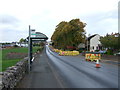
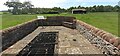
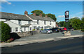
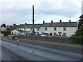
Anne T visited on 27th Aug 2019 - their rating: Cond: 3 Amb: 3 Access: 5 St Cuthbert's Well (or Kelter Well), Clifton: The enclosure for this well is to the western side of the A6, towards the southern end of Clifton village. In some ways, this well is very disappointing, as the grid over it does not allow you to see very much, apart from some stone steps leading down to what appears to be a culvert with a strong flow of water running through it.
The well has been built into an enclosure which commemorates the last battle on English soil between the retreating Jacobite army and Government troops. This took place on 18th December 1745 (the battle of Clifton Moor).
No entry on either Pastscape or Historic England, although a well is shown on their map if you enter the grid reference above.
 (PID:201922)")
I was unable to find any entry for it in Pastscape or Historic England, but the "Springs of Living Waters: The Holy Wells of North Cumbria" by Fr John Musther includes a photograph of the well (page 35), and tells us: "At Clifton is a ‘Kelter’ Well i.e. spring; another St. Cuthbert’s church is nearby".
The enclosure was built to commemorate the site of a skirmish, recorded as Pastscape Monument No. 12044, which took place on Clifton Moor on 18th December 1745, between "(the Royal) Forces of the Duke of Cumberland, and the rearguard of rebel army under Lord George Murray". This was the last battle on English soil between the retreating Jacobite army and Government troops.
[Update September 2022: Please see the comment by Andy_Norfolk below].
You may be viewing yesterday's version of this page. To see the most up to date information please register for a free account.
 (PID:201924)")
 (PID:201923)")
Do not use the above information on other web sites or publications without permission of the contributor.
Nearby Images from Geograph Britain and Ireland:
©2016(licence)
©2022(licence)
©2021(licence)
©2016(licence)
©2016(licence)
The above images may not be of the site on this page, they are loaded from Geograph.
Please Submit an Image of this site or go out and take one for us!
Click here to see more info for this site
Nearby sites
Key: Red: member's photo, Blue: 3rd party photo, Yellow: other image, Green: no photo - please go there and take one, Grey: site destroyed
Download sites to:
KML (Google Earth)
GPX (GPS waypoints)
CSV (Garmin/Navman)
CSV (Excel)
To unlock full downloads you need to sign up as a Contributory Member. Otherwise downloads are limited to 50 sites.
Turn off the page maps and other distractions
Nearby sites listing. In the following links * = Image available
615m SW 228° Clifton Stones* Standing Stones (NY53132593)
1.1km W 278° Lowther Woodhouse Stone Row / Alignment (NY525265)
2.0km S 176° Trainford Brow Long Barrow* Long Barrow (NY5369724313)
2.0km S 178° Low Moor (Cumbria)* Long Barrow (NY53642431)
2.1km SW 236° Castlesteads (Yanwath Wood)* Ancient Village or Settlement (NY5185725187)
2.1km WSW 237° Castlesteads (Tirril) Ancient Village or Settlement (NY518252)
2.2km NW 326° Little Round Table* Henge (NY52382817)
2.3km NW 316° Brougham Hall Stone Circle (NY520280)
2.4km NNW 328° King Arthur's Round Table* Henge (NY5232528374)
2.5km SW 221° St Michael (Lowther)* Ancient Cross (NY51902445)
2.7km NW 321° Mayburgh* Henge (NY5191728428)
2.7km E 90° Leacet Hill* Cairn (NY563263)
2.8km SW 217° Castlesteads (Lowther)* Misc. Earthwork (NY51892412)
3.4km NW 310° Skirsgill Holy Well (Skirsgill) Holy Well or Sacred Spring (NY5095028560)
3.6km NW 312° Skirsgill Standing Stone* Standing Stone (Menhir) (NY50972875)
3.6km NNW 333° Plague Stone (Penrith)* Ancient Cross (NY5196329563)
3.7km WNW 292° Redhills Rock Art* Rock Art (NY50192776)
4.2km SE 141° Low Well (Great Strickland)* Holy Well or Sacred Spring (NY56242302)
4.3km NNW 333° Giants Grave, Penrith* Ancient Cross (NY51653017)
4.3km NNE 32° St Ninian's Church (Ninekirks)* Ancient Cross (NY5593629962)
4.3km N 353° Dickey Bank Holy Well (Carleton Hill) Holy Well or Sacred Spring (NY5309030660)
4.4km NNE 34° St Ninian's Preconquest Monastery (Ninekirks)* Ancient Village or Settlement (NY5607129981)
4.5km WNW 287° Dacre Parish* Stone Circle (NY49342771)
4.5km NNW 331° Penrith Museum* Museum (NY5144830339)
4.6km NNE 32° Giants Cave Holy Well (Edenhall)* Holy Well or Sacred Spring (NY5610030200)
View more nearby sites and additional images


 We would like to know more about this location. Please feel free to add a brief description and any relevant information in your own language.
 Wir möchten mehr über diese Stätte erfahren. Bitte zögern Sie nicht, eine kurze Beschreibung und relevante Informationen in Deutsch hinzuzufügen.
 Nous aimerions en savoir encore un peu sur les lieux. S'il vous plaît n'hesitez pas à ajouter une courte description et tous les renseignements pertinents dans votre propre langue.
 Quisieramos informarnos un poco más de las lugares. No dude en añadir una breve descripción y otros datos relevantes en su propio idioma.