


<< Our Photo Pages >> Giants Cave Holy Well (Edenhall) - Holy Well or Sacred Spring in England in Cumbria
Submitted by Anne T on Sunday, 17 July 2022 Page Views: 1327
Springs and Holy WellsSite Name: Giants Cave Holy Well (Edenhall) Alternative Name: St Ninian's Well (Edenhall)Country: England County: Cumbria Type: Holy Well or Sacred Spring
Nearest Town: Penrith Nearest Village: Barbary Plains
Map Ref: NY5610030200
Latitude: 54.664956N Longitude: 2.682119W
Condition:
| 5 | Perfect |
| 4 | Almost Perfect |
| 3 | Reasonable but with some damage |
| 2 | Ruined but still recognisable as an ancient site |
| 1 | Pretty much destroyed, possibly visible as crop marks |
| 0 | No data. |
| -1 | Completely destroyed |
| 5 | Superb |
| 4 | Good |
| 3 | Ordinary |
| 2 | Not Good |
| 1 | Awful |
| 0 | No data. |
| 5 | Can be driven to, probably with disabled access |
| 4 | Short walk on a footpath |
| 3 | Requiring a bit more of a walk |
| 2 | A long walk |
| 1 | In the middle of nowhere, a nightmare to find |
| 0 | No data. |
| 5 | co-ordinates taken by GPS or official recorded co-ordinates |
| 4 | co-ordinates scaled from a detailed map |
| 3 | co-ordinates scaled from a bad map |
| 2 | co-ordinates of the nearest village |
| 1 | co-ordinates of the nearest town |
| 0 | no data |
Be the first person to rate this site - see the 'Contribute!' box in the right hand menu.
Internal Links:
External Links:
I have visited· I would like to visit
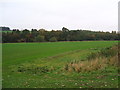
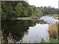
Anne T saw from a distance on 13th Sep 2022 - their rating: Cond: 1 Amb: 4 Access: 3 Giant's Cave Holy Well: Having walked to St. Ninian's Church, Ninekirks, and wandered around the site of St Ninian's preconquest monastery, it was only a short walk northwards across the field towards the location of the Giant's Cave and the River Eamont.
There was no sign of the well on the south side of the river, and the river was too big, wide and fast flowing to cross to get to the Giant's Cave, so we tried to spot it from afar.
This section of the river is dominated by red sandstone cliffs, with heavy tree cover, so it wasn't really possible to spot either the cave or the well.
The photographs show approximate locations for the well, given the 'vague' grid reference. Goodness knows how those Victorian revellers got to the cave, but there are beaches along the river, and a beautiful meadow on the south of the river for celebrations at the well to have taken place at.
 (PID:247552)")
Recorded as a holy well in the Cumbria Historic Environment Record, number 2918, CHER tells us: "The grid reference given for the well is on the same side (of the River Eamont) as St Ninian's Church [see HE List ID 1016398 'St Ninian's preconquest monastic site'], but there is nothing on the ground to suggest its exact location. It may have been on the opposite side of the river, near the Giant's Caves, which are said to have been a hermitage for St Ninian".
McIntyre, in his 1944 publication "The Holy Wells of Cumbria" quotes from Walker, the historian for Penrith, and tells us: "Sullivan and other writers inform us that the people of Penrith held fairs and pleasure gatherings at four wells on the Sundays in May. On the first Sunday of the month the meeting was at Skirsgill Well; on the second at Clifton (Westmorland) ; on the third at the Giant's Caves ... and on the fourth at Dicky Bank Well on Penrith fell". The CHER record adds: "The young people filled their bottles with water and 'Spanish Juice' and drank with each other".
This well is also listed in Jim Taylor Page's 1990 publication "Cumbrian Holy Wells" (Gazetteer, page 23). He adds that this well is dedicated to St Ninian, and at the time of publication he notes that the well was 'overgrown and rarely visited'
Does anyone have any more information about this well? Are you able to confirm it has holy associations, perhaps with St Ninian? Have you visited either this site or the nearby Giants Caves, and can confirm an exact location for this well?
Do you have any historical documentation and/or drawings you can add? Thank you.
You may be viewing yesterday's version of this page. To see the most up to date information please register for a free account.
 (PID:247553)")
 (PID:247176)")
 (PID:247175)")
Do not use the above information on other web sites or publications without permission of the contributor.
Nearby Images from Geograph Britain and Ireland:
©2009(licence)
©2009(licence)
©2005(licence)
©2009(licence)
©2009(licence)
The above images may not be of the site on this page, they are loaded from Geograph.
Please Submit an Image of this site or go out and take one for us!
Click here to see more info for this site
Nearby sites
Key: Red: member's photo, Blue: 3rd party photo, Yellow: other image, Green: no photo - please go there and take one, Grey: site destroyed
Download sites to:
KML (Google Earth)
GPX (GPS waypoints)
CSV (Garmin/Navman)
CSV (Excel)
To unlock full downloads you need to sign up as a Contributory Member. Otherwise downloads are limited to 50 sites.
Turn off the page maps and other distractions
Nearby sites listing. In the following links * = Image available
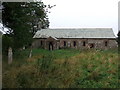
71m N 351° Giant's Cave (Cumbria)* Cave or Rock Shelter (NY56093027)
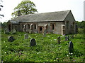
221m S 187° St Ninian's Preconquest Monastery (Ninekirks)* Ancient Village or Settlement (NY5607129981)
289m SW 214° St Ninian's Church (Ninekirks)* Ancient Cross (NY5593629962)
1.9km N 8° St Cuthbert's Well (Edenhall Park)* Holy Well or Sacred Spring (NY564321)
2.0km NNE 23° St. Cuthbert's Church (Edenhall)* Ancient Cross (NY5689832046)
2.1km NNE 18° Edenhall Cross (Langwathby)* Ancient Cross (NY5676732230)
3.0km W 278° Dickey Bank Holy Well (Carleton Hill) Holy Well or Sacred Spring (NY5309030660)
3.7km ESE 107° Winderwath Stone Circle* Stone Circle (NY5960729085)
3.9km S 177° Leacet Hill* Cairn (NY563263)
4.2km W 261° Plague Stone (Penrith)* Ancient Cross (NY5196329563)
4.2km WSW 244° King Arthur's Round Table* Henge (NY5232528374)
4.2km WSW 241° Little Round Table* Henge (NY52382817)
4.4km W 269° Giants Grave, Penrith* Ancient Cross (NY51653017)
4.5km WSW 246° Mayburgh* Henge (NY5191728428)
4.6km SSW 212° St Cuthbert's Well (Clifton)* Holy Well or Sacred Spring (NY5359326336)
4.6km W 271° Penrith Museum* Museum (NY5144830339)
4.6km WSW 241° Brougham Hall Stone Circle (NY520280)
5.2km SW 224° Lowther Woodhouse Stone Row / Alignment (NY525265)
5.2km SW 214° Clifton Stones* Standing Stones (NY53132593)
5.3km WSW 254° Skirsgill Standing Stone* Standing Stone (Menhir) (NY50972875)
5.4km WSW 252° Skirsgill Holy Well (Skirsgill) Holy Well or Sacred Spring (NY5095028560)
6.2km W 260° Bell Mount* Natural Stone / Erratic / Other Natural Feature (NY49932914)
6.4km SSW 202° Trainford Brow Long Barrow* Long Barrow (NY5369724313)
6.4km SSW 202° Low Moor (Cumbria)* Long Barrow (NY53642431)
6.4km WSW 247° Redhills Rock Art* Rock Art (NY50192776)
View more nearby sites and additional images


 We would like to know more about this location. Please feel free to add a brief description and any relevant information in your own language.
 Wir möchten mehr über diese Stätte erfahren. Bitte zögern Sie nicht, eine kurze Beschreibung und relevante Informationen in Deutsch hinzuzufügen.
 Nous aimerions en savoir encore un peu sur les lieux. S'il vous plaît n'hesitez pas à ajouter une courte description et tous les renseignements pertinents dans votre propre langue.
 Quisieramos informarnos un poco más de las lugares. No dude en añadir una breve descripción y otros datos relevantes en su propio idioma.