
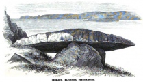
, Aubrey Burl")
<< Our Photo Pages >> St Ninian's Preconquest Monastery (Ninekirks) - Ancient Village or Settlement in England in Cumbria
Submitted by Anne T on Sunday, 18 September 2022 Page Views: 318
Multi-periodSite Name: St Ninian's Preconquest Monastery (Ninekirks)Country: England County: Cumbria Type: Ancient Village or Settlement
Nearest Town: Penrith
Map Ref: NY5607129981
Latitude: 54.662986N Longitude: 2.682535W
Condition:
| 5 | Perfect |
| 4 | Almost Perfect |
| 3 | Reasonable but with some damage |
| 2 | Ruined but still recognisable as an ancient site |
| 1 | Pretty much destroyed, possibly visible as crop marks |
| 0 | No data. |
| -1 | Completely destroyed |
| 5 | Superb |
| 4 | Good |
| 3 | Ordinary |
| 2 | Not Good |
| 1 | Awful |
| 0 | No data. |
| 5 | Can be driven to, probably with disabled access |
| 4 | Short walk on a footpath |
| 3 | Requiring a bit more of a walk |
| 2 | A long walk |
| 1 | In the middle of nowhere, a nightmare to find |
| 0 | No data. |
| 5 | co-ordinates taken by GPS or official recorded co-ordinates |
| 4 | co-ordinates scaled from a detailed map |
| 3 | co-ordinates scaled from a bad map |
| 2 | co-ordinates of the nearest village |
| 1 | co-ordinates of the nearest town |
| 0 | no data |
Internal Links:
External Links:
I have visited· I would like to visit
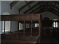
Anne T visited on 13th Sep 2022 - their rating: Cond: 1 Amb: 4 Access: 3 St Ninian's Pre-Conquest Monastic Site: See visit report for St Ninian's Church (Ninekirks) for now. More details to follow.
 (PID:247696)")
Historic England schedule this site as List ID 1016398, 'St Ninian's preconquest monastic site, site of nucleated medieval settlement, St Ninian's Church and churchyard'.
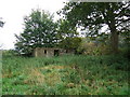
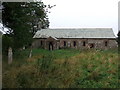
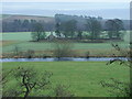
Now there is hardly anything to see, apart from a few very low 'lumps and bumps' in the ground, but the site is in an amazing location in a bend of the River Eamont, so you can see why it was chosen.
HE tell us the site was originally identified by crop marks from the air, and "clearly show the infilled ditches of enclosures, pits, field boundaries and structural foundations. The pre-Conquest monastic site lies to the east of the St Ninian's Church and is seen from aerial photographs to include an elliptical enclosure containing three rectangular structures along the inside edge of the enclosure ditch and faint traces of several other structures. The central of the three structures is sub-divided into two rooms. This form of monastic settlement typified by the circular enclosure is of early medieval Irish influence".
After a prolonged dry period, it was possible to make out some lighter areas of grass which may have run along the top of foundation lines; certainly our feet were sensitive to harder areas which ran in straight lines, and we picked out what may have been the outlines of monastic or village buildings.
You may be viewing yesterday's version of this page. To see the most up to date information please register for a free account.
 (PID:247695)")
 (PID:247697)")
Do not use the above information on other web sites or publications without permission of the contributor.
Nearby Images from Geograph Britain and Ireland:
©2005(licence)
©2009(licence)
©2009(licence)
©2009(licence)
©2008(licence)
The above images may not be of the site on this page, they are loaded from Geograph.
Please Submit an Image of this site or go out and take one for us!
Click here to see more info for this site
Nearby sites
Key: Red: member's photo, Blue: 3rd party photo, Yellow: other image, Green: no photo - please go there and take one, Grey: site destroyed
Download sites to:
KML (Google Earth)
GPX (GPS waypoints)
CSV (Garmin/Navman)
CSV (Excel)
To unlock full downloads you need to sign up as a Contributory Member. Otherwise downloads are limited to 50 sites.
Turn off the page maps and other distractions
Nearby sites listing. In the following links * = Image available
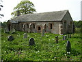
136m W 261° St Ninian's Church (Ninekirks)* Ancient Cross (NY5593629962)
221m N 7° Giants Cave Holy Well (Edenhall)* Holy Well or Sacred Spring (NY5610030200)
289m N 3° Giant's Cave (Cumbria)* Cave or Rock Shelter (NY56093027)
2.1km N 8° St Cuthbert's Well (Edenhall Park)* Holy Well or Sacred Spring (NY564321)
2.2km NNE 21° St. Cuthbert's Church (Edenhall)* Ancient Cross (NY5689832046)
2.4km NNE 17° Edenhall Cross (Langwathby)* Ancient Cross (NY5676732230)
3.0km WNW 282° Dickey Bank Holy Well (Carleton Hill) Holy Well or Sacred Spring (NY5309030660)
3.6km ESE 104° Winderwath Stone Circle* Stone Circle (NY5960729085)
3.7km S 176° Leacet Hill* Cairn (NY563263)
4.1km WSW 246° King Arthur's Round Table* Henge (NY5232528374)
4.1km WSW 243° Little Round Table* Henge (NY52382817)
4.1km W 264° Plague Stone (Penrith)* Ancient Cross (NY5196329563)
4.4km SSW 214° St Cuthbert's Well (Clifton)* Holy Well or Sacred Spring (NY5359326336)
4.4km W 272° Giants Grave, Penrith* Ancient Cross (NY51653017)
4.4km WSW 249° Mayburgh* Henge (NY5191728428)
4.5km WSW 243° Brougham Hall Stone Circle (NY520280)
4.6km W 274° Penrith Museum* Museum (NY5144830339)
5.0km SW 225° Lowther Woodhouse Stone Row / Alignment (NY525265)
5.0km SW 215° Clifton Stones* Standing Stones (NY53132593)
5.2km WSW 256° Skirsgill Standing Stone* Standing Stone (Menhir) (NY50972875)
5.3km WSW 254° Skirsgill Holy Well (Skirsgill) Holy Well or Sacred Spring (NY5095028560)
6.1km SSW 202° Trainford Brow Long Barrow* Long Barrow (NY5369724313)
6.2km SSW 203° Low Moor (Cumbria)* Long Barrow (NY53642431)
6.2km W 262° Bell Mount* Natural Stone / Erratic / Other Natural Feature (NY49932914)
6.3km WSW 249° Redhills Rock Art* Rock Art (NY50192776)
View more nearby sites and additional images


 We would like to know more about this location. Please feel free to add a brief description and any relevant information in your own language.
 Wir möchten mehr über diese Stätte erfahren. Bitte zögern Sie nicht, eine kurze Beschreibung und relevante Informationen in Deutsch hinzuzufügen.
 Nous aimerions en savoir encore un peu sur les lieux. S'il vous plaît n'hesitez pas à ajouter une courte description et tous les renseignements pertinents dans votre propre langue.
 Quisieramos informarnos un poco más de las lugares. No dude en añadir una breve descripción y otros datos relevantes en su propio idioma.