


<< Our Photo Pages >> Hart Tor North prehistoric settlement - Ancient Village or Settlement in England in Devon
Submitted by SandyG on Monday, 19 January 2015 Page Views: 2283
Multi-periodSite Name: Hart Tor North prehistoric settlementCountry: England County: Devon Type: Ancient Village or Settlement
Nearest Village: Princetown
Map Ref: SX5818572466
Latitude: 50.534730N Longitude: 4.002463W
Condition:
| 5 | Perfect |
| 4 | Almost Perfect |
| 3 | Reasonable but with some damage |
| 2 | Ruined but still recognisable as an ancient site |
| 1 | Pretty much destroyed, possibly visible as crop marks |
| 0 | No data. |
| -1 | Completely destroyed |
| 5 | Superb |
| 4 | Good |
| 3 | Ordinary |
| 2 | Not Good |
| 1 | Awful |
| 0 | No data. |
| 5 | Can be driven to, probably with disabled access |
| 4 | Short walk on a footpath |
| 3 | Requiring a bit more of a walk |
| 2 | A long walk |
| 1 | In the middle of nowhere, a nightmare to find |
| 0 | No data. |
| 5 | co-ordinates taken by GPS or official recorded co-ordinates |
| 4 | co-ordinates scaled from a detailed map |
| 3 | co-ordinates scaled from a bad map |
| 2 | co-ordinates of the nearest village |
| 1 | co-ordinates of the nearest town |
| 0 | no data |
Internal Links:
External Links:
I have visited· I would like to visit
SandyG has visited here
")
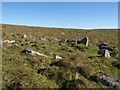
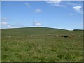
Many of the round houses are apparently unenclosed, although short lengths of walling indicate that a field system or groups of enclosures may have once been associated with this settlement. The best preserved and consequently most understandable boundary wall survives at the northern end of the settlement where an enclosed area measuring 35m by 21m defined by a 1.5m wide and 0.5m high rubble bank survives.
Leading from this enclosed area is a second bank which curves southward enclosing a substantial area. The original extent of this bank is not currently known because it peters out, but it may have originally enclosed the discrete group of houses lying to the south west. Enough evidence exists to indicate that the distribution of houses within the settlement is not haphazard and that they appear to have been laid out to take account of features such as boundaries which are no longer visible. The boundaries were not confined to the settlement and in the area to the south east a couple lengths of walling indicate that the field system once extended beyond the houses. At a number of different locations the linear arrangements of houses certainly suggests that they were once connected in some manner.
Update October 2019: This settlement is featured on the Prehistoric Dartmoor Walks (PDW) website - see their entry for the Hart Tor N. Settlement. The settlement is also recorded as Pastscape Monument No. 440082 and as MDV3791 (UNENCLOSED HUT CIRCLE SETTLEMENT in the Parish of Walkhampton) on the Devon and Dartmoor HER.
This site is also scheduled as Historic England List Entry No. 1011174 (Thirty-six stone hut circles and an irregular aggregate field system forming part of an unenclosed stone hut circle settlement 450m north of Hart Tor), which notes that fieldwork was carried out by Sandy Gerrard (SandyG).
You may be viewing yesterday's version of this page. To see the most up to date information please register for a free account.
Do not use the above information on other web sites or publications without permission of the contributor.
Nearby Images from Geograph Britain and Ireland:
©2010(licence)
©2009(licence)
©2009(licence)
©2016(licence)
©2016(licence)
The above images may not be of the site on this page, they are loaded from Geograph.
Please Submit an Image of this site or go out and take one for us!
Click here to see more info for this site
Nearby sites
Key: Red: member's photo, Blue: 3rd party photo, Yellow: other image, Green: no photo - please go there and take one, Grey: site destroyed
Download sites to:
KML (Google Earth)
GPX (GPS waypoints)
CSV (Garmin/Navman)
CSV (Excel)
To unlock full downloads you need to sign up as a Contributory Member. Otherwise downloads are limited to 50 sites.
Turn off the page maps and other distractions
Nearby sites listing. In the following links * = Image available
228m N 2° Hart Tor North ring cairn* Ring Cairn (SX5819872694)
797m NW 321° Meavy Head Settlement Ancient Village or Settlement (SX577731)
892m SSW 211° Hart Tor North circle* Stone Circle (SX57717171)
895m SSW 210° Hart Tor South Terminal Cairn* Cairn (SX57727170)
933m SSW 211° Hart Tor south row* Stone Row / Alignment (SX57687168)
953m SW 214° Hart Tor north rows* Multiple Stone Rows / Avenue (SX57637169)
1.1km SSW 207° Raddick Hill North* Ancient Village or Settlement (SX57657147)
1.3km NE 38° High Moorland Visitor Centre* Museum (SX59037348)
1.3km S 189° Raddick Hill Cist* Cist (SX57937116)
1.5km SW 226° Black Tor (Meavy)* Multiple Stone Rows / Avenue (SX5710271463)
1.5km WNW 284° Walkhampton Enclosed Settlement* Ancient Village or Settlement (SX56747286)
1.6km SW 226° Black Tor Stone Row Cairns (Stanlake)* Cairn (SX5699071370)
1.7km SW 219° Stanlake Settlement* Ancient Village or Settlement (SX57057115)
1.9km WSW 238° Leeden Tor* Stone Row / Alignment (SX5652271474)
2.1km S 173° Crazy Well Cross* Ancient Cross (SX58387039)
2.3km W 259° Ingra Tor Cist* Cairn (SX5587272083)
2.4km SW 226° Stanlake Cist* Cist (SX5641670852)
2.4km SW 225° Sharpitor NE (2) Stone Row / Alignment (SX564708)
2.5km WSW 240° Leeden Hill* Standing Stone (Menhir) (SX56017128)
2.5km SSW 209° Stan Lake Platform Cairn Circle Cairn (SX56917028)
2.6km SW 229° Sharpitor NE* Multiple Stone Rows / Avenue (SX5613670785)
2.7km NW 316° Yellowmeade Farm* Cairn (SX56357446)
2.7km ENE 58° Blackabrook* Cairn (SX60527386)
2.8km WNW 297° King's Tor* Rock Outcrop (SX557738)
2.9km WSW 256° Routrundle North* Ancient Village or Settlement (SX55387185)
View more nearby sites and additional images


 We would like to know more about this location. Please feel free to add a brief description and any relevant information in your own language.
 Wir möchten mehr über diese Stätte erfahren. Bitte zögern Sie nicht, eine kurze Beschreibung und relevante Informationen in Deutsch hinzuzufügen.
 Nous aimerions en savoir encore un peu sur les lieux. S'il vous plaît n'hesitez pas à ajouter une courte description et tous les renseignements pertinents dans votre propre langue.
 Quisieramos informarnos un poco más de las lugares. No dude en añadir una breve descripción y otros datos relevantes en su propio idioma.