

<< Text Pages >> Bergkunstmuseet / Egge Museum - Museum in Norway in Nord-Trøndelag
Submitted by TimPrevett on Sunday, 12 October 2014 Page Views: 1312
MuseumsSite Name: Bergkunstmuseet / Egge MuseumCountry: Norway Fylke: Nord-Trøndelag Type: Museum
Nearest Town: Steinkjer
Latitude: 64.021667N Longitude: 11.463278E
Condition:
| 5 | Perfect |
| 4 | Almost Perfect |
| 3 | Reasonable but with some damage |
| 2 | Ruined but still recognisable as an ancient site |
| 1 | Pretty much destroyed, possibly visible as crop marks |
| 0 | No data. |
| -1 | Completely destroyed |
| 5 | Superb |
| 4 | Good |
| 3 | Ordinary |
| 2 | Not Good |
| 1 | Awful |
| 0 | No data. |
| 5 | Can be driven to, probably with disabled access |
| 4 | Short walk on a footpath |
| 3 | Requiring a bit more of a walk |
| 2 | A long walk |
| 1 | In the middle of nowhere, a nightmare to find |
| 0 | No data. |
| 5 | co-ordinates taken by GPS or official recorded co-ordinates |
| 4 | co-ordinates scaled from a detailed map |
| 3 | co-ordinates scaled from a bad map |
| 2 | co-ordinates of the nearest village |
| 1 | co-ordinates of the nearest town |
| 0 | no data |
Internal Links:
External Links:
Museum in Nord-Trøndelag
Museum with Prehistoric and Rock Art displays. Website mainly in Norwegian with a little in English here
You may be viewing yesterday's version of this page. To see the most up to date information please register for a free account.
Do not use the above information on other web sites or publications without permission of the contributor.
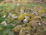
Nearby Images from Flickr


The above images may not be of the site on this page, but were taken nearby. They are loaded from Flickr so please click on them for image credits.
Click here to see more info for this site
Nearby sites
Click here to view sites on an interactive map of the areaKey: Red: member's photo, Blue: 3rd party photo, Yellow: other image, Green: no photo - please go there and take one, Grey: site destroyed
Download sites to:
KML (Google Earth)
GPX (GPS waypoints)
CSV (Garmin/Navman)
CSV (Excel)
To unlock full downloads you need to sign up as a Contributory Member. Otherwise downloads are limited to 50 sites.
Turn off the page maps and other distractions
Nearby sites listing. In the following links * = Image available
327m E 89° Egge West Eggevammen* Barrow Cemetery
1.1km ENE 58° Olvisheim Stone Rings* Stone Row / Alignment
1.2km ENE 62° Egge East Olvisheim Stone Row / Alignment
1.4km E 82° Tingvoll Stone Setting* Stone Circle
1.5km WSW 240° Skåtangen* Cairn
2.8km N 3° Gjevranmarka Gravfelt* Barrow Cemetery
3.0km SE 129° Ner-Trana Mounds* Barrow Cemetery
3.1km S 175° Skrubbhaugen* Barrow Cemetery
3.5km SE 127° Tranaskogvegen* Barrow Cemetery
3.6km E 87° Midjo* Round Barrow(s)
3.7km N 349° Gjevranslottet* Hillfort
4.4km NW 306° Bardal Carvings* Carving
4.4km ENE 74° Helge Gravfelt* Standing Stones
4.4km W 269° Hoøya Cairns* Cairn
4.7km E 93° Vive barrow cemetery* Barrow Cemetery
5.1km SSW 200° Vistavegen* Cairn
6.2km SW 217° Toldnes cairns* Barrow Cemetery
6.9km SSW 213° Limbuhaugen* Cist
6.9km ESE 111° Søndre Bruem* Round Barrow(s)
7.1km SSW 200° Vist burial mound* Round Barrow(s)
7.5km S 188° Ålberg* Barrow Cemetery
7.6km ESE 119° Røliveien-Strugstad* Round Barrow(s)
7.9km E 95° Risberg* Round Barrow(s)
8.0km ENE 72° Øyster-Råde* Round Barrow(s)
8.3km NNW 334° Tessemvegen* Cairn
View more nearby sites and additional images


 We would like to know more about this location. Please feel free to add a brief description and any relevant information in your own language.
 Wir möchten mehr über diese Stätte erfahren. Bitte zögern Sie nicht, eine kurze Beschreibung und relevante Informationen in Deutsch hinzuzufügen.
 Nous aimerions en savoir encore un peu sur les lieux. S'il vous plaît n'hesitez pas à ajouter une courte description et tous les renseignements pertinents dans votre propre langue.
 Quisieramos informarnos un poco más de las lugares. No dude en añadir una breve descripción y otros datos relevantes en su propio idioma.