

<< Our Photo Pages >> Gjevranslottet - Hillfort in Norway in Nord-Trøndelag
Submitted by kenntha88 on Sunday, 15 November 2015 Page Views: 1257
Iron Age and Later PrehistorySite Name: GjevranslottetCountry: Norway Fylke: Nord-Trøndelag Type: Hillfort
Nearest Town: Steinkjer
Latitude: 64.054114N Longitude: 11.449471E
Condition:
| 5 | Perfect |
| 4 | Almost Perfect |
| 3 | Reasonable but with some damage |
| 2 | Ruined but still recognisable as an ancient site |
| 1 | Pretty much destroyed, possibly visible as crop marks |
| 0 | No data. |
| -1 | Completely destroyed |
| 5 | Superb |
| 4 | Good |
| 3 | Ordinary |
| 2 | Not Good |
| 1 | Awful |
| 0 | No data. |
| 5 | Can be driven to, probably with disabled access |
| 4 | Short walk on a footpath |
| 3 | Requiring a bit more of a walk |
| 2 | A long walk |
| 1 | In the middle of nowhere, a nightmare to find |
| 0 | No data. |
| 5 | co-ordinates taken by GPS or official recorded co-ordinates |
| 4 | co-ordinates scaled from a detailed map |
| 3 | co-ordinates scaled from a bad map |
| 2 | co-ordinates of the nearest village |
| 1 | co-ordinates of the nearest town |
| 0 | no data |
Internal Links:
External Links:
")
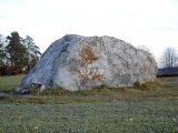
On the high hilltop called "Slottet" is the remains of a Iron Age hillfort. The fort is today visible as overgrown remains of walls. The hill that is oriented north east to south west is very steep on three sides. On the fourth side where the modern footpath is located are the remains of two walls.
The hillfort had two walls, the first one is around 50-60 metres long and is visible today as heaps of stones overgrown with moss. The wall is around 3 metres wide but some places the wall have collapsed and can be difficult to see.
A little more distance to the top of the hill is another and much stronger wall. It continues along the south east side of the hill. This wall is also visible as overgrown stones and this wall has been much larger than the outer wall, it is around 4-6 metres wide.
Some smaller excavations were done in 1994 and charcoal dating has shown that the hillfort was built around 400-500AD in the age of migration. Some few other iron age artifacts were also found. Getting up to the hillfort is easy, there are signs from the main highway where to take off from the road and at the end of the country road is a small parking lot and information poster. From here to the hillfort is a footpath that leads to the top of the hill.
You may be viewing yesterday's version of this page. To see the most up to date information please register for a free account.
")
")
")
")
")
")
Do not use the above information on other web sites or publications without permission of the contributor.
Click here to see more info for this site
Nearby sites
Click here to view sites on an interactive map of the areaKey: Red: member's photo, Blue: 3rd party photo, Yellow: other image, Green: no photo - please go there and take one, Grey: site destroyed
Download sites to:
KML (Google Earth)
GPX (GPS waypoints)
CSV (Garmin/Navman)
CSV (Excel)
To unlock full downloads you need to sign up as a Contributory Member. Otherwise downloads are limited to 50 sites.
Turn off the page maps and other distractions
Nearby sites listing. In the following links * = Image available
1.1km SE 134° Gjevranmarka Gravfelt* Barrow Cemetery
3.0km WSW 250° Bardal Carvings* Carving
3.4km SSE 152° Olvisheim Stone Rings* Stone Row / Alignment
3.5km SSE 151° Egge East Olvisheim Stone Row / Alignment
3.7km S 169° Bergkunstmuseet / Egge Museum Museum
3.7km SSE 164° Egge West Eggevammen* Barrow Cemetery
4.0km SSE 148° Tingvoll Stone Setting* Stone Circle
4.4km S 188° Skåtangen* Cairn
4.8km NW 323° Tessemvegen* Cairn
5.3km SW 225° Hoøya Cairns* Cairn
5.5km ESE 117° Helge Gravfelt* Standing Stones
5.5km SE 129° Midjo* Round Barrow(s)
6.3km SSE 151° Ner-Trana Mounds* Barrow Cemetery
6.6km SE 126° Vive barrow cemetery* Barrow Cemetery
6.7km SSE 149° Tranaskogvegen* Barrow Cemetery
6.8km S 172° Skrubbhaugen* Barrow Cemetery
8.4km E 98° Øyster-Råde* Round Barrow(s)
8.5km S 188° Vistavegen* Cairn
9.1km SSW 200° Toldnes cairns* Barrow Cemetery
9.3km WSW 255° Hammer Helleristninger* Rock Art
9.3km SE 131° Søndre Bruem* Round Barrow(s)
9.6km ESE 110° Øysterskei Nordre* Cairn
9.6km ESE 117° Risberg* Round Barrow(s)
9.9km SSW 198° Limbuhaugen* Cist
10.3km E 81° Fornes standing stone* Standing Stone (Menhir)
View more nearby sites and additional images


 We would like to know more about this location. Please feel free to add a brief description and any relevant information in your own language.
 Wir möchten mehr über diese Stätte erfahren. Bitte zögern Sie nicht, eine kurze Beschreibung und relevante Informationen in Deutsch hinzuzufügen.
 Nous aimerions en savoir encore un peu sur les lieux. S'il vous plaît n'hesitez pas à ajouter une courte description et tous les renseignements pertinents dans votre propre langue.
 Quisieramos informarnos un poco más de las lugares. No dude en añadir una breve descripción y otros datos relevantes en su propio idioma.